Hi, what do you want to do?
University of Texas at Austin
Perry Castaneda Library Map Collection: Mexico Maps
This site provides a wealth of maps relating to the country of Mexico.
Other
Didactalia: Mapas Interactivos: Physical Relief of Mexico
Explore the map of Mexico and try to identify the types of landforms. Available in multiple languages.
Maps of Mexico
Virtual Picture Travel Map of Massachusetts
Click on Massachusetts on the US map in order to Travel there and take a virtual tour of Boston. Visit places of interest such as Harvard University, MIT, John F. Kennedy Library and Museum, the Freedom Trail, Copley Square, Trinity...
Maps of Mexico
Virtual Picture Travel Map of Massachusetts
Click on Massachusetts on the US map in order to Travel there and take a virtual tour of Boston. Visit places of interest such as Harvard University, MIT, John F. Kennedy Library and Museum, the Freedom Trail, Copley Square, Trinity...
Geographic
Mexico (Maps)
Maps of Mexico, including one with major cities, and another with the Mexican states.
Houghton Mifflin Harcourt
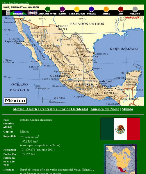
Holt, Rinehart and Winston: America Del Norte: Mexico
This site has a map of Mexico in Spanish, with informational data also presented in Spanish about the country. Land mass, population, life expectancy, literacy, industry, agriculture, minerals and resources are among the topics...
Foundation for the Advancement of Mesoamerican Studies
Famsi: Map of Maya Area
Map shows the locations of Mayan sites in Belize, El Salvador, Guatemala, Honduras and Mexico.
Curated OER
Perry Castaneda Map Collection: Latin America Map
This political map of Latin America and South America is in color and features major cities.
Curated OER
Map of Mexico
Take a tour through the country of Mexico in this enchanting site. Students will learn about the culture and visit with the people as they explore the geography, history, and environment of Mexico. It includes maps, classroom activities,...


