Hi, what do you want to do?
Centers for Disease Control and Prevention
Current Cigarette Smoking Among Adults Infographic
Adult cigarette smoking has decreased in recent years, but it is still the number one cause of preventable disease and death in America. An infographic breaks cigarette smoking down by education level, geographical region, gender, race,...
National Geographic
National Geographic: Geostories: A Rocky Mountain Bio Blitz
National Geographic's 2012 BioBlitz took place in Rocky Mountain National Park, Colorado. This GeoStory captures the spirit and wildlife discoveries of the 2012 BioBlitz.
National Geographic
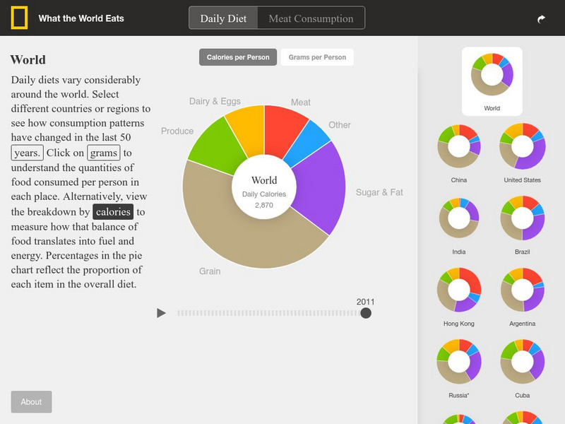
National Geographic: What the World Eats
National Geographic presents a visual application to illustrate what types of daily diet caloric intake is from 1961-2011. Views of the whole world and breakdowns of individual nations are shown.
National Geographic
National Geographic: Geostories: The Ab Cs of Mp As
Each slide in this GeoStory includes information about an aspect of a marine protected aea, as well as a link to related content from National Geographic Education.
National Geographic Kids
National Geographic Kids: Animals: Poison Dart Frogs
National Geographic site engages users with colorful photos and extensive facts about Poison Dart Frogs.
National Geographic
National Geographic: Staple Food Crops of the World
An interactive map identifying where many of the staple foods are grown around the world. In addition, find questions that can be answered based on review of the maps, fast facts about the crops, and terminology.
National Geographic
National Geographic: Geostories: Tracking Animal Migrations
This interactive Geostory illustrates how animal tracking data helps us understand how individuals and populations move within local areas and migrate across oceans and continents.
National Geographic
National Geographic: Geostories: Voyages Across the Ocean
Use this GeoStory in formal or informal instruction to provide information about the voyages of numerous historical navigators and explorers. This GeoStory helps students understand the importance of ocean exploration in contributing to...
National Geographic
National Geographic: What the World Eats
This interactive website offers pie charts showing what the world eats and what 22 different countries eat. It also allows you to choose by year as well. These include food groups, calories, and grams overall and per category.
National Geographic
National Geographic: Geostories: Public Transportation
Use this interactive GeoStory to explore the major public transportation systems around the world.
National Geographic
National Geographic: Coral Reef Food Web
Explore the food web in a coral reef with these illustration. Identify the consumers, producers, and decomposers that are located within this ecosystem. Site includes illustration exploring the different food chains as well as questions...
National Geographic
National Geographic: Society: Timeline: World War Ii
One stop shop for everything you need to know about WWII. This interactive timeline features all the major events leading to war, major battles and turning points, rulers during the war, and the consequences of this war. Vibrant...
National Geographic
National Geographic: Exploring the Chesapeake: Then and Now
Resource provides an interactive map that takes you to places on the Chesapeake Bay that John Smith explored and you find out the historical events that occurred. Pictures and drawings of time accompany the explanations.
National Geographic
National Geographic: Geostories: Geography on the Job
Each story point in this Geostory includes images, a short bio, and an interactive mapping tool that allows students to see the regions where geography work takes place.
National Geographic
National Geographic: The Electoral College
Discover how the United States elects its president by using an Electoral College. A map shows how the Electoral College's 538 members are distributed throughout all fifty states and the District of Columbia.
National Geographic
National Geographic: Geostories: American Wetlands
Visit this GeoStory to discover the wetland ecosystems across the United States.
National Geographic
National Geographic: Geostories: Citizen Scientists Across the u.s.
Meet some people who volunteer in citizen science efforts across the country.
National Geographic
National Geographic: Geostories: Emerging Explorers
Find out how modern-day explorers change the way we change our world in this interactive Geostory activity.
National Geographic
National Geographic: Geostories: Earth's Extremes
Follow this GeoStory to learn about Earth's extremes, from highest and lowest, to hottest and coldest.
National Geographic
National Geographic: Geostories: Hominin History
Launch the GeoStory to find out about hominins. There are many, many extinct hominins, a fraction of which are represented in this activity.
National Geographic
National Geographic: Geostories: Ocean Exploration
This Geostory illustrates pivotal events in undersea understanding.
National Geographic
National Geographic: Geostories: Port Cities
Use this GeoStory in classroom instruction to provide information about how port cities help exchange goods and services.
National Geographic
National Geographic: Geostories: Participatory Mapping in the Caribbean
Explore the Caribbean's Grenadine chain of islands through the work of a cartographer and mapping expert.
National Geographic
National Geographic: The Walrus and the Carpenter
This GeoStory walks learners through the poem, "The Walrus and the Carpenter" with an image and map accompanying each stanza, and in many cases individual lines. The images are either literal representations or metaphors of a line in the...
Other popular searches
- National Geographic Mapmachine
- National Geographic Clone
- National Geographic Kids
- National Geographic Video
- National Geographic Online
- National Geographic for Kids
- Egypt National Geographic
- National Geographic Society
- National Geographic: Clone
- National Geographic Cloning
- National Geographic Explorers
- Egypt+ National Geographic


