Curated OER
Unnatural Scavenger Hunt
For this science observation scavenger hunt worksheet, students use 10 riddles to find items hidden in an outside area then map the locations of each item.
Curated OER
The Cold War: Chapter 9: Lesson 1
Used as a quick review of the Cold War, Korean War, and Cuban Missile Crisis, this presentation could be in many scenarios. However, the graphics and question types seem more appropriate for younger students, while the content is geared...
Curated OER
Police Action: The Korean War, 1950-1953
Students explore why the United States became involved in the war in Korea. They discuss the confict between Truman and MacArthur, culminating in the latter's dismissal from command. They identify on a world map foreign countires...
Curated OER
Wales Quiz 2
In this country of Wales learning exercise, learners answer short answer questions about famous people, famous places, and more about the country. Students complete 17 short answer questions.
Curated OER
USA State Tag / Mississippi River Shuffle
Students reinforce the geographic location of the states of the U.S.A.
Curated OER
Minoan Pottery - A History Lesson
Accent your next ancient pottery art project with easy-to-follow background information. An article describes the background, significance, and history of Minoan Pottery. It includes links to images, sites and ideas. Tip: This is a great...
Curated OER
A Map as a Tool
Students study the concept of using a map as a tool with the usage of a balloon designed to mimic the features of the Earth with the major features marked and shown on the balloon.
Curated OER
Problem Solving: Draw a Diagram
This problem solving PowerPoint presents a detailed, logical sequence of steps to follow in order to solve a story problem. The thinking processes described are given in text and represented by a visual model. After discussing the...
Curated OER
World Climates Study Guide
In this geography skills learning exercise, students respond to 24 fill in the blank and multiple choice questions about the climate regions and characteristics of the world.
Curated OER
Working with Contour Maps
In this contour maps worksheet, high schoolers use contour maps to determine the slope and steepness of different land masses. This worksheet has 16 fill in the blank questions.
Curated OER
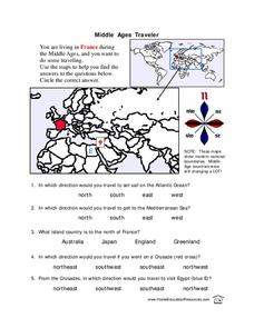
Middle Ages Traveler
In this map worksheet, young scholars are given three maps of France to use to answer multiple choice questions. Students complete an activity from the perspective of a Middle Ages traveler.
Curated OER
Birds and Migration
Young scholars actively simulate bird migration. In this animal migration lesson, students participate in an activity that simulates the migration of birds. The teacher discusses with the class the hazards and difficulties birds face...
Curated OER
Finding Your Way Using Maps and Globes
Students identify the similarities and differences between different maps and globes. Individually, they create a map of their classroom along with a compass rose. They also practice reading maps as a class and finding specific locations.
Curated OER
Intermediate Sentence Completion Exercise 4
In this online interactive grammar skills learning exercise, students examine 10 sentences that are missing words and select the appropriate words to complete each of the sentences and match them to the sentences. Student answers are...
Curated OER
Scooter Signal
Young scholars practice the use of hand signals to designate right or left turns. In this safety lesson, students ride a scooter following paths set up to look like sidewalks and roads. Young scholars practice forming the proper signals...
Curated OER
English Exercises: Adjectives and Prepositions
For this online interactive English worksheet, students respond to 39 fill in the blank questions that require them to use adjectives and prepositions appropriately. Students may submit their answers to be scored.
Curated OER
Mapping Your Schoolyard Habitat
Students explore the terrain, structures, plants and signs of habitats around their schoolyard. They draw a sketch map showing the different areas around the schoolyard. Students identify the location of weeds and native plants on their...
Curated OER
Maps! Maps! Maps!
Third graders examine and identify different types of maps. They review the types of projections and which maps are better for different information. They answer comprehension questions at the end of the lesson plan.
Curated OER
Walking on Maps
Learners are introduced to the various types of maps and their functions. As a class, they play a game similar to twister to review map concepts. They answer questions about the map and use the internet to view larger maps of the world.
Curated OER
Weather Facts
Students study weather and weather measurement tools. In this weather lesson, students read and discuss weather myths and superstitions as well as weather terminology. Students then work in groups to complete weather stations for wind,...
Curated OER
Applying the Pythagorean Theorem to find Distances Between Cities
Students solve problems using the Pythagorean Theorem. For this geometry lesson, students identify the Pythagorean Triple and use it to solve real life problems.
Curated OER
Earth Viewer Welcomes You- Web View of the Earth
For this science and Internet technology worksheet, students access the given web site to look at a current view of the Earth's surface. They enter longitude and latitude co-ordinates before answering 8 questions. They change the...
Dorling Kindersley
Punctuation Practice
Need some punctuation practice? Challenge your third or fourth graders' editing skills with a helpful instructional activity on punctuation. After naming different types of punctuation marks, they rewrite a paragraph that has multiple...
Illustrative Mathematics
Bank Shot
Young geometers become pool sharks in this analysis of the angles and lengths of a trick shot. By using angles of incidence and reflection to develop similar triangles, learners plan the exact placement of balls to make the shot....


