Brooklyn Museum
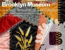
"Workt by Hand": Hidden Labor and Historical Quilts
Just like a painting or the symbols on a flag, quilts can express ideas that reflect a cultural context, space, and time. The class discusses the history of quilt making throughout US history and what different types of quilts mean. They...
Curated OER
Westward Expansion
Students locate California and New York on a map and explore available means of travel in the 19th century. Students explore the role of trade in pioneer America and simulate various barter transactions.
Curated OER
Explore the Elements of Art
Students recognize elements of art such as texture, shape line and color. In this elements of art lesson, students create a still life picture with oil pastel or crayons. Students define elements of art vocabulary....
Curated OER
Chocolate Preferences Voting and Graphing Techniques
Young scholars practice sampling and graphing techniques. In this data collection and interpretation lesson, students write and conduct surveys about chocolate preferences and then collect their data. Young scholars graph the data in...
Curated OER
Signs and Symbols
Sixth graders carefully analyze a triptych of the nativity, paying close attention to the lines, shapes and symbols included in the artwork. They explore the role of the Catholic church in society at the time the piece was created and...
Curated OER
The Díne (Navajo) Native American Tribe
Students participate in a variety of activities to become familiar with the Navajo Indians. In this Díne (Navajo) Native American tribe lesson, students understand where the Navajo tribe lived and find them on a map. Students discuss the...
Curated OER
Latitude and Longitude
Students identify latitude, longitude, prime meridian, international date line, and equator. They compute the latitude and longitude of different objects.
Curated OER
Making Maps
In this map making worksheet, students learn about the science of making maps, which is cartography. They then answer the 11 questions on the worksheet. The answers are on the last page.


