Curated OER
Compass Rose for the New Millennium
Sixth graders are introduced to the concepts of a compass rose and how it used in relationship to reading maps in geography. The lesson is meant to build upon prior knowledge and skills.
Indian Land Tenure Foundation
Create a Map
Do your students have a connection to their natural environment? Create neighborhood maps together with your little learners. The instructional activity starts as the class talks about where they live and what their homes look like. They...
EngageNY
Close Reading of Bullfrog at Magnolia Circle: Predators and Prey
Reading is fantastic, especially when it's reading about bullfrogs. Kids get cozy with predator/prey relationships as they hone their information-reading skills. They start out as they read a portion of the text aloud, then they...
Ontario
Reading Graphic Text
Do students really need to be taught how to read cartoons, comic books, and comic strips? Yes. Just as they need to learn how to read other forms of graphic text such as diagrams, photos, timetables, maps, charts, and tables. Young...
McGraw Hill
Study Guide for Island of the Blue Dolphins
Dive your class into a reading of Island of the Blue Dolphins with this in-depth study guide. Breaking the novel into three parts, the resource begins each section with a focus activity that identifies a specific theme or question to be...
Curated OER
Drake's West Indian Voyage 1588-1589
Learners investigate several maps detailing Sir Francis Drake's voyages. In this geography lesson, students practice reading maps and locating the precise locations of where Sir Francis Drake visited. Learners create an outline of the...
Curated OER
Reading Maps of the East Pacific Rise
Young scholars make qualitative and quantitative observations and use various maps to investigate the features of the East Pacific Rise The study actual bathymetric maps of the EPR region. They identify key features of the ridge and...
Curated OER
We're on the Map!
Students identify a variety of topographic map symbols. They make generalizations about an unidentified community by reading and interpreting map symbols.
Curated OER
Around the Town
In the world of GPS, make sure your kids can still read maps and determine distances between locations. You will need neighborhood street maps, ideally of your class' home turf. Ask kids questions about different locations in relation to...
Curated OER
Learning About Maps
Learners take a "field trip" with the teacher through the school then draw a diagram of what they saw. They bring the maps to the computer lab where they create electronic maps using the software program Neighborhood Map Machine.
Curated OER
Way to Go! Create a Road Map Game
Learners create a travel game of one of the United States. They research a state of their choice and create a travel game using a common road map. They interpret map symbols as they calculate map mileage for their games. They create...
Tennessee State Museum
An Emancipation Proclamation Map Lesson
Did the Emancipation Proclamation free all slaves during the Civil War? Why was it written, and what were its immediate and long-term effects? After reading primary source materials, constructing political maps representing information...
Illustrative Mathematics
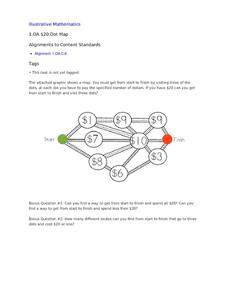
$20 Dot Map
Challenge the addition skills of young learners with this open-ended math problem. The task is simple, get from start to finish by connecting a series of three numbers. The trick is that the sum of the numbers must be less than or equal...
Institute for Geophysics
Understanding Maps of Earth
Here is your go-to student resource on primary geography concepts, including facts about the surface of the earth and its hemispheres, latitude and longitude, globes, types of maps, and identifying continents and oceans.
EngageNY
Establishing Structures for Reading: Getting the Gist (Chapter 1)
Class members review expectations for successful discussions before reading chapter one of A Long Walk to Water by Linda Sue Park. They engage in a think-pair-share to discuss the gist of the text and add their thoughts to their Readers'...
Curated OER
China Quest
Read and research information on China. Young researchers complete a knowledge hunt about China then locate and describe each location using directional words. They recognize the word meaning through context clues and application practice.
Curated OER
Fossil Fuels (Part I), The Geology of Oil
Junior geologists work through three mini-lessons that familiarize them with the formation and location of fossil fuels. Part one involves reading about petroleum and where it comes from via a thorough set of handouts. A lab activity...
Curated OER
Lewis and Clark
Students investigate Lewis and Clark. In this Lewis and Clark lesson plan, students search the Internet for information about Lewis and Clark and the Corps of Discovery. Students use maps to understand the explorations and decide which...
Curated OER
Caves
Explore caves with your class! Your scholars will participate in scientific observation, research, inference and deduction, reading, vocabulary, and writing activities about caves with this lesson plan. This resource contains five...
Curated OER
The Monkey's Paw
For this reading comprehension worksheet, students complete a variety of activities which demonstrate understanding of the book The Monkey's Paw .
Anti-Defamation League
Impact of the U.S. Expansion on Indigenous People and Stereotypes About Native American People
The 2004 U.S. bicentennial sparks a discussion about its meaning and importance to United States history. Readings, maps, tables, and reflective writing prompt small groups to explore the westward expansion, Lewis and Clark, and how...
Curated OER
MAPPING YOUR NEIGHBORHOOD
Learners uses atlases, maps, and Web resources to generate and examine maps of their own neighborhoods. This activity serve as background for the map-reading tasks in the next lessons.
Curated OER
Transportation and Mapping
Students view murals that depict various modes of transportation. They discuss the importance of maps to navigation and create a map. They compare and contrast transportation of the past with modes of transportation used today.
Curated OER
Finding Your Way Using Maps and Globes
Students identify the similarities and differences between different maps and globes. Individually, they create a map of their classroom along with a compass rose. They also practice reading maps as a class and finding specific locations.
Other popular searches
- Reading Maps and Globes
- Reading Maps and Charts
- Worksheets for Reading Maps
- Reading Maps and Coordinates
- Reading Maps and Graphs
- Reading Maps First Grade
- Map Reading Military Maps
- Reading Maps of America
- Reading Maps Worksheet
- Reading Maps South America
- Reading Maps Maths
- Thinking Maps Reading


