Curated OER
Guaqui Church Main Entrance
Explore the Bolivian Highlands with this interactive virtual tour. Click on each picture to enlarge it and see a satellite image of it from Google Earth.
Curated OER
Guaqui Church Interior
Explore the Bolivian Highlands with this interactive virtual tour. Click on each picture to enlarge it and see a satellite image of it from Google Earth.
Curated OER
Jesus De Machaca
Explore the Bolivian Highlands with this interactive virtual tour. Click on each picture to enlarge it and see a satellite image of it from Google Earth.
Curated OER
Jesus De Machaca Church
Explore the Bolivian Highlands with this interactive virtual tour. Click on each picture to enlarge it and see a satellite image of it from Google Earth.
Curated OER
Jesus De Machaca Church Main Entrance
Explore the Bolivian Highlands with this interactive virtual tour. Click on each picture to enlarge it and see a satellite image of it from Google Earth.
Curated OER
Church Altar
Explore the Bolivian Highlands with this interactive virtual tour. Click on each picture to enlarge it and see a satellite image of it from Google Earth.
Curated OER
Church Painting
Explore the Bolivian Highlands with this interactive virtual tour. Click on each picture to enlarge it and see a satellite image of it from Google Earth.
Curated OER
Communal Lunch Ajtapi
Explore the Bolivian Highlands with this interactive virtual tour. Click on each picture to enlarge it and see a satellite image of it from Google Earth.
Curated OER
Community Leaders Mallkus
Explore the Bolivian Highlands with this interactive virtual tour. Click on each picture to enlarge it and see a satellite image of it from Google Earth.
Curated OER
Konko Wankani Ruins
Explore the Bolivian Highlands with this interactive virtual tour. Click on each picture to enlarge it and see a satellite image of it from Google Earth.
Curated OER
Konko Wankani Ruins
Explore the Bolivian Highlands with this interactive virtual tour. Click on each picture to enlarge it and see a satellite image of it from Google Earth.
Curated OER
Burma Political Map
An easy to read political map of Burma. Be sure to scroll down to see a satellite image of Burma from Google Earth. You can also find some facts about Burma at the bottom of the page.
Discovery Education
Discovery Education: Physical Science
The Discovery Channel provides numerous lesson plans dealing with the physical sciences. Content is organized by grade level, but all lesson plans include suggestions for adaptations for older or younger audiences.
Other
Lehigh University: Land Use Change
An inquiry-based science unit for middle school students centered on how human activities affect environmental changes related to land use. The lessons integrate technology and lab activities while teaching about today's land use and how...
The Washington Post
The Gulf Coast in Katrina's Wake
This vivid look at New Orleans and the surrounding areas truly gets to the core of the destruction imposed by Hurricane Katrina. A graphic overview, panoramic photographs, and short videos are just a few of the amazing resources offered...
Curated OER
Picture of a Gps Satellite
Where are you and where are you going? Visit this site and learn the discovery and purpose of GPS, Global Position Systems.
Science Education Resource Center at Carleton College
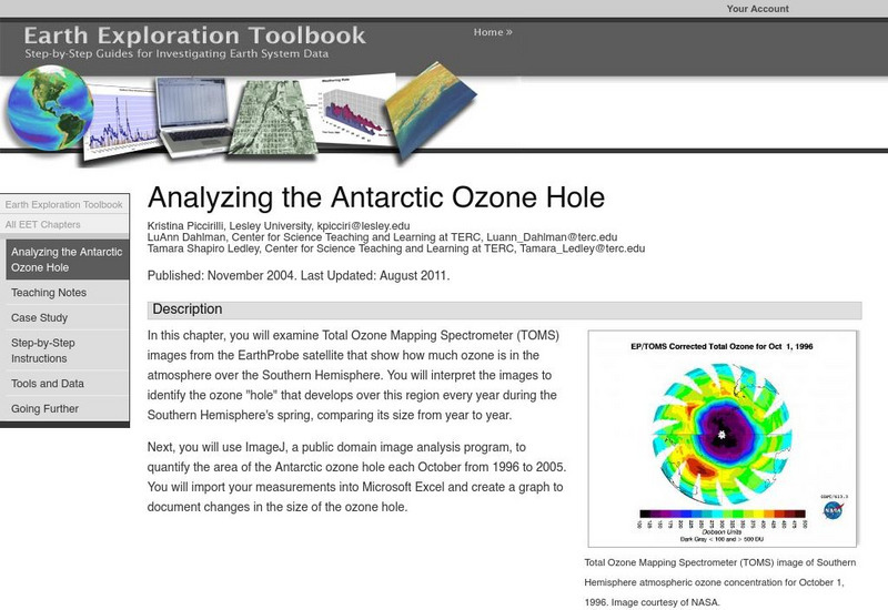
Serc: Analyzing the Antarctic Ozone Hole
In this chapter, you will examine Total Ozone Mapping Spectrometer (TOMS) images from the EarthProbe satellite that show how much ozone is in the atmosphere over the Southern Hemisphere. You will interpret the images to identify the...
Curated OER
Visual Satellite Observer: Mir Space Station's 15 Years in Space Ends
Details of Mir's re-entry into the Earth's atmosphere after 15 years in space. Includes information on Mir's mission, configuration, and history.
Curated OER
Viewers in Baghdad Watching Al Arabiya Satellite Tv Station, 2004
The BBC provides a general overview of the country of Iraq. Content includes a focus on Saddam Hussein, Iraq's press and media, an Iraqi timeline of key events, and much more.
Curated OER
Hdf Image From Cdat
This site provides a concise explanation of the bleeching process, its effect on corals, and the causes of bleeching.
California Institute of Technology
The Discovery of Eris, the Largest Known Dwarf Planet
Until the discovery of Eris, Pluto was known as the largest Keiper belt object. This dwarf planet has replaced Pluto in size and is accompanied by a satellite that has been given the name Dysnomia. Learn about this distant world here...
American Geosciences Institute
American Geosciences Institute: Earth Science Week: Exploring Color Maps
An activity where students study the Ozone Hole poster used that brings together colorful images of over 30 years of satellite observations of the ozone hole. Students interpret the color on the globes to see how the ozone hole has...
PBS
Pbs Learning Media: Earth's Systems: The Water Planet
Observe different forms of water and how it covers about 75 percent of Earth's surface in this media gallery captured by NASA and the U.S. Geological Survey (USGS). Use the satellite and ground images in this resource to enhance student...
US Navy
United States Naval Observatory Homepage
United States Naval Observatory is a unique observatory run by the Navy. It does some of the grunt work of astronomy -- keeping accurate time, determining positions of stars (astrometry), etc. They are responsible for publishing the...
Other popular searches
- Satellite Imagery
- Hurricane Satellite Images
- Infrared Satellite Imagery
- Image Satellite
- Aerial and Satellite Imagery
- Satellite Images of Erosion
- Science Satellite Imagery
- Satellite Imagery Weather Maps
- Octagonal Image Satellite


