NOAA
A Moving Crust
Young scientists piece together the geological puzzle that is the earth in the third and final lesson of this earth science series. With the help of numerous multimedia resources and a series of engaging hands-on activities, students...
Curated OER
Can You See What I See?
Students gain an understanding of the methods used to explore the earth's surface. Students create a time line leading to the first satellite image of the Earth that includes the various methods utilized to observe the earth's surface.
Curated OER
Earthquake Formation
Students explore earthquakes. For this natural disaster and engineer career education lesson, students identify features of the earth's surface that increase the likelihood of an earthquake. Students use visual aids to locate the earth's...
Curated OER
Understanding Geologic Time
Students view Understanding Geologic Time on the Internet or by CD-Rom to explore the length of time that the Earth has existed.
Curated OER
Basin & Range Faulting
Students identify that the crust of the earth is constantly moving and that with the exception of faults accompanied by earthquakes, this rate of movement is far too slow to notice. Then they print a copy of cross-section map A and...
Curated OER
Your Own Backyard
Students study Earth's features and their local environments. In this Earth's features lesson, students take a field trip to observe a natural environment and students sketch their observations of the nature. Students watch videos about...
Curated OER
Science: Draining the Land - the Mississippi River
Students use topographic maps to identify parts of rivers. In addition, they discover gradient and predict changes in the channels caused by variations in water flow. Other activities include sketching a river model with a new channel...
Curated OER
Deep Thoughts
Learners examine what lies within the Earth. They research and create scale models illustrating the layers of the Earth and write skits advocating a travel plan to send a probe into the Earth's mantle.
Curated OER
Devastation of Indian Quake
Learners read an online article at CNNfyi.com to determine what happened in India after an earthquake. They determine the magnitude of this earthquake and address the issue of relief efforts from other countries.
Curated OER
How Much Water is Available in the Atmosphere for Precipitation?
Students explore the relationship between the amount of water in the atmosphere available for precipitation and the actual precipitation observed by satellite. They examine seasonal changes in precipitation. They practice using Internet...
Curated OER
Active Faulting in Idaho
Students use CAD maps to explore active faults in Idaho. Through observation of maps, they explore the layers of the Quaternary and Holocene faults. Individually, or in groups, they identify characteristics of faults such as scarps,...
Curated OER
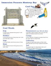
Forests of the Sea
Young scholars read about and conduct experiments to learn about the vegetation under Monterey Bay. In this Monterey Bay lesson, students read about and look at brightly colored pictures of the different types of seaweed that grows in...
Curated OER
Design an Island
Students explore islands. They create a two- or three-dimensional map of an island. They explain how the topography of an area influences the location of water sources, ecosystems, and human settlements. Lesson includes adaptations for...
Curated OER
Carving Mountains
Students explore geography by participating in an illustration activity. In this land-form instructional activity, students define vocabulary terms associated with glaciers and forests. Students utilize pens, cardboard and pottery clay...
Curated OER
Dating Sedimentary Strata
Students investigate how the age of sedimentary strata is determined. For this sedimentary strata lesson, students work through problems that show that geological history covers millions of years. They distinguish between relative and...
Curated OER
Wetlands: Pave or Save?
Students discuss the characteristics of wetlands and how to make them more productive. Using a map, they locate the major wetlands in the United States and color them using a key. They read an article and in groups answer discussion...


