TRAIN Educational & Community Services
Multicultural Activities
From catching stars developed by African pygmy tribes to chop stix pick-up or the Hanukkah dreidel, use this list of diverse multicultural activities to help your learners draw connections to unique cultures of the...
Curated OER
Australian Map (Regions)
In this Australian map worksheet, students research and label the regions of Australia on an Australian map. Students check their labeled regions when completed.
Curated OER
Australia
Sixth graders study the continent of Australia. In this Geography lesson plan, 6th graders create an Australian city using their knowledge of Australian cities. Students participate in a game about the continent.
Curated OER
Travel to Mesoamerica
Students research books, watch movies, and look on the internet to find information on ancient America, Mexico, and Central America. In this Mesoamerica lesson plan, students participate in a social studies unit on North America of the...
Curated OER
Antarctica
Students explore the Antarctic continent, Australia's role in Antarctic exploration and development, the issues concerning Antarctica's future and the needs of the Antarctic community.
US Apple Association
Apples: A Class Act! (Grades 4–6)
Middle schoolers have a bushel of fun as they engage in activities and research core facts about apples. Packed with suggestions for in-class activities and out-of-class research, the colorful 6-page packet is sure to satisfy hungry...
Curated OER
Mapping Australia
In this mapping Australia activity, students locate and label various features and places on a blank map, 10 total. A reference web site is given for additional activities.
Curated OER
Lesson Plan on Map Skills for South Asia
Seventh graders observe and discuss an overhead transparency map of South Asia. In small groups, they label a blank map of South Asia, and listen to a lecture on the realm.
Curated OER
Land Use in Australian Agriculture
Seventh graders research and map agricultural practices of Australia. They complete a worksheet about their research.
Curated OER
Racism No Way
Students explore different cultural influences and their contribution to Australian identities. They reflect on their own backgrounds and making links with their peers, reflect on our heritage. Students view My family- My Australia,...
Curated OER
A New Federation
Young scholars describe the relationships between state and federal parliaments in Australia. They identify responsibilities shared between federal and state and territory governments. Students explore an alternative federal structure...
Curated OER
Global Connections: Internet Research
In this geography Internet research worksheet, students find out facts about the capital cities of 12 nations. Students then research facts about Australia, and also find out the country of origin for 4 prominent organizations such as...
Curated OER
We've got the whole world in our hands
Students explore spatial sense in regards to maps about the globe. In this maps lesson plan, students label oceans, locate the continents and poles, follow directions, and explain the symbols on a map.
Curated OER
Yo-ho, Yo-ho a Viking's Life for Me
Students complete a unit of lessons on the Vikings. They analyze maps, read and discuss myths, summarize the main ideas from resource materials, watch videos, sing a song, draw a picture to illustrate Norse mythology, and define key...
Curated OER
History/Geography
Students review North America, Africa, Europe and Asia. They identify Australia as the smallest continent. They identify Australia as an island continent nicknamed "the land down under." They color a map of Australia.
Curated OER
Australia Cities Map Quiz
In this online interactive geography quiz activity, students respond to 17 identification questions regarding Australian cities. Students have 3 minutes to finish the timed quiz.
Curated OER
Oceania Map Quiz
In this online interactive geography quiz learning exercise, learners respond to 14 identification questions about Oceania. Students have 2 minutes to complete the quiz.
Curated OER
Middle Ages Traveler
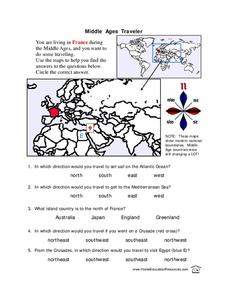
In this map worksheet, young scholars are given three maps of France to use to answer multiple choice questions. Students complete an activity from the perspective of a Middle Ages traveler.
Curated OER
World Map and Globe - Lesson 15 Mountains of the World
Learners locate major world mountain ranges. In this geography lesson, students identify major mountain ranges on 6 on of the 7 continents on a large world physical map.
Curated OER
World Map Labels
In this geography skills worksheet, students identify the countries and bodies of water labelled on the maps of the world, Africa, Asia, Canada, Europe, the Caribbean, the Middle East, North America, Australia, and South America.
Curated OER
Geography Worksheet
In this geography skills worksheet, students respond to 14 short answer questions by using maps and atlases. The maps and atlases are not included.
Curated OER
Map of Australia
In this geography of Australia worksheet, students color and label a map with major states, cities and physical features. The Australian state borders are shown but not labeled.
Curated OER
The Physical Geography of Australia, Oceania, and Antarctica
Young scholars access information from the United States Geological Survey's Web site This Dynamic Earth to research the Ring of Fire. They answer four questions and then apply what they have learned to create a bulletin board display.


