Curated OER
State Capitals- Online Interactive
In this state capitals worksheet, students learn to match the capital cities to the 50 states. Next to each name of the state, students fill in the capital city from a list that is provided. This is an online interactive worksheet.
Curated OER
Desert Fever: A Student-Centered Approach to Learning About the Middle East
Explore the exciting and diverse geography, people, history, governments, and economies of the Middle East. Curious minds develop a basic vocabulary of Arabic terms and work with various materials to create an aesthetically pleasing,...
Curated OER
State Nicknames Quiz
In this online interactive geography quiz worksheet, students examine the chart that includes the names of 49 states. Students identify the nicknames of the states in 6 minutes.
Curated OER
Biggest Cities in Each State Quiz
In this online interactive geography quiz worksheet, students examine the chart that includes the names of 50 U.S. states. Students identify the names of the two largest cities in each state in 8...
Curated OER
4th Grade Geography Multiple Choice
In this grade 4 geography worksheet, 4th graders complete a total of 25 multiple choice questions relating to 4th grade geography concepts. An answer key is provided.
Curated OER
Roundtable
Fifth graders apply the Five Themes of Geography as they relate to the U.S., the world, and specific places in United States history. They recognize and label geographical locations on a map of the United States.
Curated OER
Names and Places
Students explore where jobs are done. In this careers and geography lesson plan, students locate places in Canada on a map and list jobs that are done in their area of Canada. Lesson includes extension and differentiation ideas.
Curated OER
California's Golden History: 1848-1880
Using a variety of online resources, learners study life and society in California during the gold rush. They use a map to identify area where gold was located, explore pre-selected websites, describe mining practices, and create an...
Curated OER
Louisiana State Word Jumble
In this word jumble worksheet, students unscramble the letters to spell words associated with the state of Louisiana. Students spell 20 words.
Curated OER
Coldest US Cities Quiz
In this online interactive geography quiz worksheet, students respond to 20 identification questions about the coldest cities in the United States. Students have 4 minutes to complete the quiz.
Curated OER
U.S. States - The Midwest States
In this geography and math worksheet, students complete the simple addition equations and match the sums to the colors. Students then color the Midwest States by the color code.
Curated OER
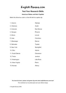
American States and Their Capital- Test Your Research Skills Worksheet
In this geography skills worksheet, students match the American state listed on the left with its capital city listed on the right by drawing a line from one to the other.
California Polytechnic State University
Australian Geography Unit
At the heart of this resource is a beautifully detailed PowerPoint presentation (provided in PDF form) on the overall physical geography of Australia, basic facts about the country, Aboriginal history, and Australia culture and lifestyle.
Curated OER
US City Quality of Life Analysis and Comparison
Students analyze US census data and criteria to compare and measure the quality of life in the country's fifty largest cities. After accessing the 2005 quality of life world report online, students conduct their study to compare three...
Curated OER
Geography Quiz 18
In this geography activity, students answer short answer questions about the geography all over the world. Students complete 10 short answer questions.
Curated OER
Geography: US States and Capitals Picture/Word #4- Trace the Words
In this geography activity, 3rd graders trace sentences about the capital cities of 5 states. They write sentences about capitals about Topeka, Baton Rouge, and Annapolis.
Curated OER
Geography: US States and Capitals Pictures/Words #2
In this geography worksheet, 3rd graders trace sentences about the capital cities of 5 states. They write sentences about capitals including Hartford, Denver, and Dover.
Curated OER
Physical and Human Geography Review Worksheet and Study Guide
In this geography skills worksheet, students respond to 30 short answer questions pertaining to physical and human geography.
Curated OER
States and Capitals, Mountains and Rivers
Students identify geographical locations in the midwestern United States. In this geography lesson plan, students identify 12 states and capitals and geographical features in the region by using U.S. maps. Students use blank maps to fill...
Curated OER
A Tough Nut to Crack
Sixth graders explore agriculture by examining world geography. In this pecan cultivation lesson, 6th graders identify the history of the famous nut and the impact it has on the U.S. economy, diet and human body. Students define...
Curated OER
Establishing Borders: The Expansion of the United States 1846-48
Students investigate how the United States acquired land after the Revolutionary War ended. In this establishing borders instructional activity, students use maps to identify territories acquired by the US and the states that later...
Curated OER
Map It With Pixie
Fourth graders use the computer program 'Pixie' to create a topographic, detailed map for the state they live in. In this mapping skills lesson, 4th graders use Pixie to make a map of their state that includes topographic features, state...
Curated OER
A Look at the Population Density of the United States
Students acquire census information and create maps of the population density of the United States on different scales. They role play the roles of workers of a retail company and they use the population data to market to their customers.
Sharp School
US Geography Landmark Commercial
Experience famous geographical landmarks around the United States right from the comfort of your very own classroom. Learners research national landmarks, such as the Grand Canyon, Yellowstone National Park, and Niagara Falls, and then...


