National Geographic
National Geographic: Forces of Nature
This educational site provides information about deadly forces of nature, such as, tornadoes, volcanoes, hurricanes, and earthquakes.
National Geographic
National Geographic: Ecosystem Imbalance in the World
In this lesson, learners build on their knowledge of individual impacts on the ocean to see how the whole system can react to threats and changes. They examine ways in which human actions throw marine ecosystems out of balance, explore...
National Geographic
National Geographic: Encyclopedia: Asia Resources: Environment and Economy
Through descriptive photos and and encyclopedic entry understand the environment and economic systems throughout Asia.
National Geographic
National Geographic: Mission: Explore: Geography Awareness Week
Learn about geography in an entirely new way with short adventures for all ages. Each mission is an exciting and challenging exploration is which you will see the world in new ways.
National Geographic
National Geographic: A River Puzzle
Use this lesson plan from National Geographic Education to explore rivers and their watersheds, using where they live as an example. Necessary vocabulary for the lesson is included as well as a puzzle for students to figure out that...
National Geographic
National Geographic: Exploring the Chesapeake: Then and Now
Resource provides an interactive map that takes you to places on the Chesapeake Bay that John Smith explored and you find out the historical events that occurred. Pictures and drawings of time accompany the explanations.
National Geographic
National Geographic: My Wonderful World: World Wall Maps (Pdf)
Make your own full color or black and white mosaic wall map on your own printer. World maps, continents, Asian regions, and oceans are available for downloading, printing, and assembling.
National Geographic
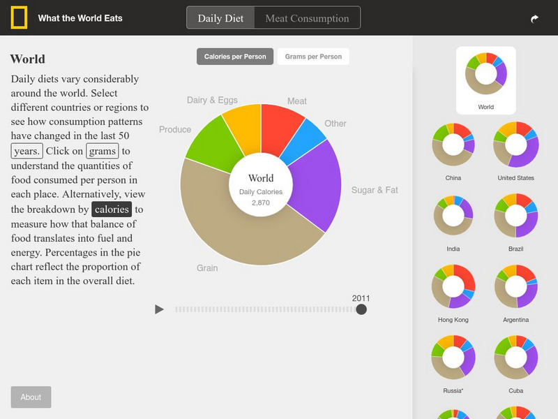
National Geographic: What the World Eats
This interactive website offers pie charts showing what the world eats and what 22 different countries eat. It also allows you to choose by year as well. These include food groups, calories, and grams overall and per category.
National Geographic
National Geographic: Human Impacts on the Environment
Humans impact the physical environment in many ways: overpopulation, pollution, burning fossil fuels, and deforestation. Changes like these have triggered climate change, soil erosion, poor air quality, and undrinkable water. These...
National Geographic
National Geographic: American Genius: Perseverance
Students investigate the importance of failure to the process of innovation by investigating several items that were invented by accident. They share one "failure to success" story by creating a 3-panel comic strip poster, and then write...
National Geographic
National Geographic: The Politics of Place Naming
Students use an online geographic information system (GIS) to uncover the geographic and social context of streets named after Martin Luther King, Jr. They map street locations to identify regional patterns in honoring King, consider...
National Geographic
National Geographic: To Build an Island
"This lesson gives students a basic overview of the geography of islands. They learn where islands are located throughout the world and will study two very different island groups (the Philippines and the British Isles) to illustrate the...
National Geographic
National Geographic: My Wonderful World: Geography Is 10 Cool Things
Why is geography important? You will find 10 reasons that answer this question on this concise but informative site.
National Geographic
National Geographic: Educator Resources: Extreme Weather on Other Planets
Find lesson plans, worksheets, photo galleries, and related links for teaching about the weather systems of planets in our solar system.
National Geographic
National Geographic: Geostories: A Rocky Mountain Bio Blitz
National Geographic's 2012 BioBlitz took place in Rocky Mountain National Park, Colorado. This GeoStory captures the spirit and wildlife discoveries of the 2012 BioBlitz.
National Geographic
National Geographic: Geostories: American Wetlands
Visit this GeoStory to discover the wetland ecosystems across the United States.
National Geographic
National Geographic: Geostories: Citizen Scientists Across the u.s.
Meet some people who volunteer in citizen science efforts across the country.
National Geographic
National Geographic: Geostories: Emerging Explorers
Find out how modern-day explorers change the way we change our world in this interactive Geostory activity.
National Geographic
National Geographic: Geostories: Earth's Extremes
Follow this GeoStory to learn about Earth's extremes, from highest and lowest, to hottest and coldest.
National Geographic
National Geographic: Geostories: Hominin History
Launch the GeoStory to find out about hominins. There are many, many extinct hominins, a fraction of which are represented in this activity.
National Geographic
National Geographic: Geostories: Ocean Exploration
This Geostory illustrates pivotal events in undersea understanding.
National Geographic
National Geographic: Geostories: Port Cities
Use this GeoStory in classroom instruction to provide information about how port cities help exchange goods and services.
National Geographic
National Geographic: Geostories: Participatory Mapping in the Caribbean
Explore the Caribbean's Grenadine chain of islands through the work of a cartographer and mapping expert.
National Geographic
National Geographic: The Walrus and the Carpenter
This GeoStory walks learners through the poem, "The Walrus and the Carpenter" with an image and map accompanying each stanza, and in many cases individual lines. The images are either literal representations or metaphors of a line in the...
