



Lesson Planet
Search educational resources
  • Sign In Try It Free
  • AI Teacher Tools
    • Discover Resources Search reviewed educational resources by keyword, subject, grade, type, and more
    • Curriculum Manager (My Content) Manage saved and uploaded resources and folders To Access the Curriculum Manager Sign In or Join Now
    • Browse Resource Directory Browse educational resources by subject and topic
    • Curriculum Calendar Explore curriculum resources by date
    • Lesson Planning Articles Timely and inspiring teaching ideas that you can apply in your classroom
    • Our Story
    • Frequently Asked Questions
    • Testimonials
    • Contact Us
  • Pricing
  • School Access
    • Your school or district can sign up for Lesson Planet — with no cost to teachers
      Learn More
  • Sign In
  • Try It Free

Hi, what do you want to do?

Create a lesson plan
Generate resources with 80+ AI teacher tools
Search 200,000 instructional videos
Find a teaching resource
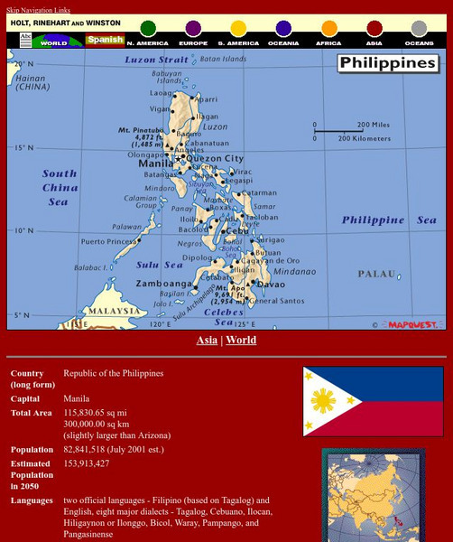
Holt, Rinehart and Winston: World Atlas: Philippines GraphicHolt, Rinehart and Winston: World Atlas: Philippines Graphic
Publisher
Houghton Mifflin Harcourt
Curator Rating
Educator Rating
Not yet Rated
Graphic

Holt, Rinehart and Winston: World Atlas: Philippines

Curated by ACT
This Holt, Rinehart and Winston: World Atlas: Philippines graphic also includes:
  • Map
  • Join to access all included materials

This map of the Philippines from MapQuest is a clear map labeling the cities, islands, and physical features. There is also a chart of some quick facts about the country.

3 Views 0 Downloads

Additional Tags

hrw atlas: philippines, philippines, maps
Show More Show Less

Resource Details

Grade
9th - 10th
Subjects
Social Studies & History
2 more...
Resource Type
Graphics & Images
Audiences
For Administrator Use
2 more...
Lexile Measures
0L

See similar resources:

Graphic

Holt, Rinehart and Winston: World Atlas: Brunei

Houghton Mifflin Harcourt
This is a good map of Brunei showing its rivers, some relief, and makes clear the two parts that make up this country on the island of Borneo. Also included are some quick facts. From Holt, Rinehart, and Winston.
9th - 10th Social Studies & History
Graphic

Holt, Rinehart and Winston: World Atlas: United States

Houghton Mifflin Harcourt
Features a detailed map of the United States with some basic facts. Click on each state name to get even a more detailed map and information.
9th - 10th Social Studies & History
Graphic

Holt, Rinehart and Winston: World Atlas: Uruguay

Houghton Mifflin Harcourt
An excellent map of Uruguay accompanied by detailed information about the country.
9th - 10th Social Studies & History
Graphic

Holt, Rinehart and Winston: World Atlas: Suriname

Houghton Mifflin Harcourt
View an excellent map of Suriname accompanied by current, detailed information about this interesting country.
9th - 10th English Language Arts
Graphic

Holt, Rinehart and Winston: World Atlas: Canada

Houghton Mifflin Harcourt
A detailed map showing the provinces and territories of Canada. You can enlarge the details by clicking on any area or name on the map.
9th - 10th Social Studies & History
Graphic

Holt, Rinehart and Winston: World Atlas: South America

Houghton Mifflin Harcourt
Features a map of all the countries in South America. Click on the name of a country to get a more detailed map and information on that country.
9th - 10th Social Studies & History
Graphic

Holt, Rinehart and Winston: World Atlas: Myanmar (Burma)

Houghton Mifflin Harcourt
Check out this map of Burma showing the major cities and the Irrawaddy River running the length of the country. There are also some quick facts listed about the country.
9th - 10th Social Studies & History
Graphic

Holt, Rinehart and Winston: World Atlas: Brazil

Houghton Mifflin Harcourt
Explore this detailed map of Brazil with accompanying country facts.
9th - 10th Social Studies & History
Graphic

Holt, Rinehart and Winston: World Atlas

Houghton Mifflin Harcourt
This site provides geographic maps of the world by continent, ocean, and country.
9th - 10th Social Studies & History
Graphic

Holt, Rinehart and Winston: World Atlas: Taiwan

Houghton Mifflin Harcourt
Grab quick facts about Taiwan (capital, total area, population, languages, literacy, religions, government, currency, industry, and more) while looking at a map, complete with cities, elevations, bodies of water, longitude, and latitude....
9th - 10th Social Studies & History
Try It Free
© 1999-2026 Learning Explorer, Inc.
Teacher Lesson Plans, Worksheets and Resources

Sign up for the Lesson Planet Monthly Newsletter

Open Educational Resources (OER)

  • Health
  • Language Arts
  • Languages
  • Math
  • Physical Education
  • Science
  • Social Studies
  • Special Education
  • Visual and Performing Arts
View All Lesson Plans

Discover Resources

  • Our Review Process
  • How it Works
  • How to Search
  • Create a Collection

Manage Curriculum

  • Edit a Collection
  • Assign to Students
  • Manage My Content
Contact Us Site Map Privacy Policy Terms of Use