Lesson Planet
Search educational resources
  • Sign In Try It Free
  • AI Teacher Tools
    • Discover Resources Search reviewed educational resources by keyword, subject, grade, type, and more
    • Curriculum Manager (My Content) Manage saved and uploaded resources and folders To Access the Curriculum Manager Sign In or Join Now
    • Browse Resource Directory Browse educational resources by subject and topic
    • Curriculum Calendar Explore curriculum resources by date
    • Lesson Planning Articles Timely and inspiring teaching ideas that you can apply in your classroom
    • Our Story
    • Frequently Asked Questions
    • Testimonials
    • Contact Us
  • Pricing
  • School Access
    • Your school or district can sign up for Lesson Planet — with no cost to teachers
      Learn More
  • Sign In
  • Try It Free

Hi, what do you want to do?

Create a lesson plan
Generate resources with 80+ AI teacher tools
Search 200,000 instructional videos
Find a teaching resource
Newberry: Migration and Settlement: Map 5: Fremont Survey: Missouri Oregon, 1843 Lesson PlanNewberry: Migration and Settlement: Map 5: Fremont Survey: Missouri Oregon, 1843 Lesson Plan
Publisher
The Newberry Library
Resource Details
Curator Rating
Educator Rating
Not yet Rated
Grade
K - 1st
Subjects
Social Studies & History
2 more...
Resource Type
Lesson Plans
Audiences
For Administrator Use
1 more...
Lexile Measures
1140L
Lesson Plan

Newberry: Migration and Settlement: Map 5: Fremont Survey: Missouri Oregon, 1843

Curated by ACT

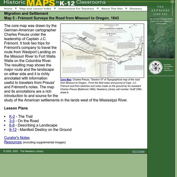
Lesson plan on migration and settlement in the U.S. ca. 1843, uses primary source map of the Missouri-Oregon survey done by Fremont and supplemental resources.

3 Views 0 Downloads

Concepts

westward expansion

Additional Tags

newberry: migration and settlement: map 5: fremont survey: missouri-oregon, 1843, road from missouri to oregon, 1843, exploration of missouri to oregon, a nation expanding west (1790-1860), european exploration of america, exploration and expansion

Classroom Considerations

  • Knovation Readability Score: 3 (1 low difficulty, 5 high difficulty)

See similar resources:

Unit Plan

Community Connections with Geography and the Newspaper

Newspaper Association of America
Understanding geography and government begins at the local level. Using maps and the parts of a newspaper, a unit plan introduces the concept of community. It starts with the creation of classroom and school maps, and then moves through...
K - 12th Science
CCSS: Adaptable
Lesson Plan

Massive Migrations

National Wildlife Federation
Turn your students into flocks of migratory birds for this fun lesson on animal migration. Prior to the activity, the teacher creates four different migration routes in the classroom or any available open space, labeling nesting...
K - 4th Science
CCSS: Adaptable
Lesson Plan

Animal Migrations

SeaWorld
Here is a fabulous set of activities for your young scientists. Each lesson contains map, hands-on, and game activities that will help the class understand why and how animals migrate from one place to another. First they'll examine the...
K - 3rd Social Studies & History
Worksheet

Street Mapping

abcteach
What's around the block? Or down the street? Ask your pupils to tap into their map skills by drafting the area around their home and school.
1st - 5th Math
Lesson Plan

Newberry: Migration and Settlement: Map 4, "Nouvelle Orleans", 1723

The Newberry Library
Lessons based on a map of French settlement in and around New Orleans which teaches students about adaptation to new environments. Includes maps, supplemental material, and curators notes.
K - 1st Social Studies & History
Lesson Plan

Newberry: Exploration and Encounter: Map 1: The World Columbus Knew in 1482

The Newberry Library
Newberry Library presents historical map on the Age of Exploration with lesson plans for all ages k-12. Includes curator notes and a wealth of supplemental resource material.
K - 1st Social Studies & History
Lesson Plan

Newberry: Exploration and Encounter: Map 2: Indian Map of the Southeast, 1721

The Newberry Library
K-12 lessons using historical maps from Newberry Library presents an Indian map of the Southeast, ca. 1721. Students use maps to understand how spatial relationships are represented. Links to supplemental resources and reference material.
K - 1st Social Studies & History
Lesson Plan

Newberry: Exploration and Encounter: Map 3, Captain Cook and Hawaii, 1778

The Newberry Library
Map and primary source information provide first-hand account of exploration and encounters between Europeans and Hawaiians. Includes lesson plans for k-12, links to reference material and supplemental resources, and curators notes.
K - 1st Social Studies & History
Lesson Plan

Newberry: Political and Military History: Map 15: The World at War, 1944

The Newberry Library
Lesson for K-12 using historical map teaches students about the relationship between perspectives of the world and map projections.
K - 1st Social Studies & History
Lesson Plan

Newberry: Geography of Transportation: Map 12: Auto Trails of Florida, Ca. 1924

The Newberry Library
Lessons for students K-12 using historical maps teach students about the history of travel and tourism by car, identifying the technological and economic changes taking place in the 20th Century.
K - 1st Social Studies & History
Try It Free
© 1999-2026 Learning Explorer, Inc.
Teacher Lesson Plans, Worksheets and Resources

Sign up for the Lesson Planet Monthly Newsletter

Open Educational Resources (OER)

  • Health
  • Language Arts
  • Languages
  • Math
  • Physical Education
  • Science
  • Social Studies
  • Special Education
  • Visual and Performing Arts
View All Lesson Plans

Discover Resources

  • Our Review Process
  • How it Works
  • How to Search
  • Create a Collection

Manage Curriculum

  • Edit a Collection
  • Assign to Students
  • Manage My Content
Contact Us Site Map Privacy Policy Terms of Use