NOAA
Mapping the Deep-Ocean Floor
How do you create a map of the ocean floor without getting wet? Middle school oceanographers discover the process of bathymetric mapping in the third installment in a five-part series of lessons designed for seventh and eighth graders....
Curated OER
Maps and the Pictures in Our Heads
Geographers of all ages examine different types of maps. They draw maps of their environment, utilizing both three-dimensional and picture maps. They interpret map information, noting how it can sometimes be misleading. Some good...
Owl Teacher
Introduction to World of Geography Test
Assess your learners on the five themes of geography and the most important key terms and concepts from an introductory geography unit. Here you'll find an assessment with 15 fill-in-the-blank and 14 multiple-choice questions, sections...
Curated OER
Using the Library for More than Research Papers
Use the repository of resources that modern libraries hold to your advantage during National Library Week.
ProCon
Drug Use in Sports
The ancient Greeks used performance enhancing drugs, such as opium juice, when they participated in the original Olympic Games. Pupils research a website with debate topics to decide if athletes' use of such drugs in modern sports is...
Curated OER
Using Data from Sensors
Beginning with a discussion about using technology to collect data, this resource includes a video about the next Mars rover as an example. Young scientists are taught that filtering is necessary before collected data can be analyzed....
Curated OER
Simple Route Map
Students identify the best route between various locations on a map. In this map skills lesson, students use a landscape picture map to find routes to and from certain places. Students use map markers to highlight the routes.
Curated OER
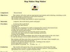
Map Maker, Map Maker
Map maker, map maker, make me a map! Your class can sing this tune as they work to create their own regional maps by taping paper to the wall, projecting an overhead transparency image, and tracing. Where this lesson plan intends for the...
Curated OER
Traveling/Mapping
Students examine routes to gold. In this California gold rush lesson, students map land and water routes to California. Students use maps to copy the routes that they want to market to gold diggers.
Curated OER
Designing and Creating Earth Science Lessons with Google Earth
Everything from adding an overlay to uploading images to navigating the software, teachers become apt at using Google Earth™ in the classroom to create Earth Science lessons.
Curated OER
Why All Maps Lie
Eighth graders discover the fundamental advantages/disadvantages of both maps and globes. They see that maps may distort size, shape, distance and direction. They discuss the advantages and applications of 5 types of map projections and...
Curated OER
How Big is the Playground: Creating a Map
Young scholars create a topographical map of an area outside of the school. In this mapping lesson, students compile data on angles, distances, and key landmarks for a predetermined area on the school grounds to create a map using...
NET Foundation for Television
1850-1874 The Kansas-Nebraska Act
How the Kansas-Nebraska Act created Bleeding Kansas is complicated—until scholars research and examine documents from the time. After completing activities that include mapping, photo, document analysis, and discussion, learners...
Cornell University
Constructing and Visualizing Topographic Profiles
Militaries throughout history have used topography information to plan strategies, yet many pupils today don't understand it. Scholars use Legos and a contour gauge to understand how to construct and visualize topographic profiles. This...
Curated OER
Story Elements Map
In this excellent story elements map worksheet, students view and discuss the advantages and disadvantages of using a graphic organizer to help structure stories and compositions. To my eye, this graphic organizer will help students...
Curated OER
Location, Location, Location: Civilization's Ultimate Advantage
Learners discover how geographical advantages, locational and regional, ultimately led to western Eurasian societies' disproportionate accounting of world power and innovation. They utilize a workbook which can be downloaded within this...
Curated OER
Rivers Run Through It
Using a relief map of New York State, learners answer questions about the distance between different cities, identify bodies of water, and more. First, they discuss vocabulary related to the Hudson River area. Then, they complete a...
Curated OER
River Run Through It
With vocabulary lists, worksheets, and more, this lesson sets learners on an exploration of the Hudson River area. They read an essay about the area, analyze a relief map of New York State, and complete a worksheet.
NET Foundation for Television
1850-1874 African American Settlers
Go West, young man! Scholars investigate the impact of African American settlers moving to the Nebraska territory, following the passage of the Kansas-Nebraska Act in the mid 1800s. Using primary sources, timelines, maps, and...
Curated OER
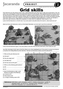
Grid Skills
In this geography instructional activity, students use grid references on a map to locate places in the pictures given. They also identify another advantage of using a grid map, which they have an overhead view of the content to prevent...
Curated OER
Map Lesson Plan
Fourth graders locate and label major sites related to the Revolutionary War in the Hudson River Valley. They examine topographical features of each site and list a few of these features and list two advantages of each military site.
Curated OER
From Restriction Maps to Cladograms
Biology aces analyze restriction maps to determine the relationships among different primate species and then complete a cladogram. Preface this lesson with an explanation of how restriction enzymes are used to create the DNA maps....
Howard Hughes Medical Institute
Sorting Finch Species
Don't just tell your class about Darwin's finches ... show them! Sort some of science's most famous birds using an interactive lesson. Learners try their hand at classifying finches using song, sonogram, and beak appearance, as well as...
Curated OER
Matching the Globe with the Map
Students examine how to use a globe. In this globe and map comparison lesson plan, students discuss how the globe and map are alike when looking at Africa and Antarctica. Students investigate shapes and sizes of globes versus maps.


