Curated OER
Countries of the World
Students define the meaning of the word country. In this countries of the world map lesson plan, students identify boundaries, countries, and symbols within countries on the map. Students distinguish the words country and continent.
Curated OER
Setting Boundaries
Students investigate the determination of the boundaries of various countries. They work in small groups to research a country's political history and past boundary issues and territorial disputes.
Curated OER
Countries of the World
Students identify countries on a world map. In this map skills lesson, students define the word "country" and use post-it notes to locate several countries on a world map.
Artisan Global
QuakeFeed Earthquake Map, Alerts and News
Amateur seismologists explore Earth's earthquakes in real time using a variety of map styles and parameter selections.
Curated OER
Microsoft Publisher Country Brochure
Learners explore geographic information. In this geography and technology instructional activity, students choose a county and answer related questions on a Webquest. Learners create a word web and design a country brochure.
Curated OER
Community, State, Country
First graders identify the town, county, state, and country in which they reside and the places where people work. They draw a picture of one of the places where people work.
Curated OER
A World of Information
Students analyze data and statistics about countries around the world. They read graphs and charts, color a world map to illustrate the top ten statistics about the world, and write a paragraph to summarize their information.
Curated OER
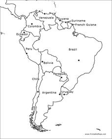
South America Outline Map
In this outline map learning exercise, students discover and investigate the physical boundaries of the countries in South America. The names of countries and a star to mark the capital city are included.
Curated OER
Blank Europe Map
Simple blank map, limitless possibilities! Here is a single-page resource of a blank map of Europe, without any country boundaries or text.
Curated OER
Philippines- Neighboring Countries & Water Boundaries
In this Philippines worksheet, students answer multiple choice questions and label the diagram with neighboring countries and water boundaries. Students complete 16 questions.
Curated OER
Religion within the Boundaries of Mere Reason
In this online interactive philosophy worksheet, students respond to 15 multiple choice questions about Religion within the Boundaries of Mere Reason by Immanuel Kant. Students may submit their answers to be scored.
Curated OER
European Country Map
In this Europe political map worksheet, students examine the national boundaries. The country names are labeled on the map.
Curated OER
From America, With Love
Students research the experiences of specific immigrant groups in the United States. Letters are written from imaginary immigrants to relatives in their countries of origin, including historically accurate details.
College Board
2012 AP® Human Geography Free-Response Questions
Why do countries create boundaries? Scholars explore similar ideas using prompts from the 2012 AP Human Geography test. Pupils also test their acumen with questions on agriculture and the growth of Islam.
Curated OER
Changing Borders
Students explain that the boundaries between countries are not permanent, then analyze current events and stories as examples of cooperation and conflict. They describe a place using physical and human characteristics.
Curated OER
Title: Rivers as Borders
Students are introduced to the concept of borders. They read maps and identify rivers that separate different countries and states. They examine how or why a landform such as a river border might be the reason for different cultures.
Curated OER
Boundaries
Pupils identify and analyze the boundaries which exist between urban and rural, wildness and country and among rural areas, country, town, and city. Students actively participate in planning, obtaining materials, setting goals and...
Curated OER
Boundaries
Students are introduced to the term of mental mapping. Individually, they develop their own mental map of Washington state and discuss as a class what makes a boundary. They draw their mental map on paper and compare it with their...
Curated OER
Is A Nation Always A Region?
Students define the term, "nation," and analyze the boundaries established in Africa by colonial powers. In small groups, they participate in a simulated United Nations, develop a list of questions, analyze the nations of Africa, and...
Curated OER
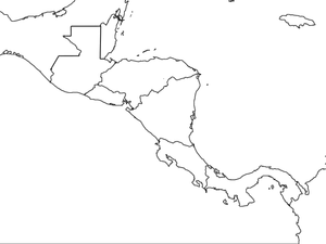
Central America Map wtih Country Borders
In this blank outline map worksheet, students explore the political boundaries of Central America and the nations there. This map may be used in a variety of classroom activities.
Curated OER
How Are Boundaries Made, Kept, Broken?
Learners perform raps and analyze issues among the rich and poor. They explore how countries are labeled as "third world" and "first world." They create a dialectical journal and examine the country of Nigeria through the reading of...
Curated OER
North America: Three Countries Map
In this North American political map worksheet, students examine the boundaries of the three countries of North America.
Curated OER
Know Your Boundaries: Earthquake Lessons in the Classroom
With all the recent attention on Haiti, and now Chile, it is the perfect time to teach your students about earthquakes!
Curated OER
World Map and Globe
Pupils locate and identify continents and countries. In this world map lesson, students locate and identify one country on each continent.


