Curated OER
Assessing Quality of Life
Eleventh graders research quality of life indicators for a list of countries looking at such things as infant mortality rate, and gross domestic product. They rank the countries from best to worst regarding quality of life issues.
Curated OER
Cultural Maps
Fifth graders examine map elements. In small groups they create a map of an imaginary country that includes a title, legend, directional indicator, scale, boundaries, capital cities, country name, and icons of five natural resources. ...
Curated OER
Mending the Rift
Learners determine what factors identify a country's political borders. After reading an article, they investigate questions surrounding the Great Rift Valley. On a map, they trace the valley from Asia through Africa and research the...
Curated OER
Migrating Across Borders
Students research and map the migratory patterns of the golden-winged warbler. They develop a strategy to protect this species and, in teams representing different countries, negotiate treaties with each other to protect the bird.
Curated OER
Mapping the Middle East
Students examine how the countries of the Middle East were created. They explore the influence of various political and geographic factors in their creation. They list the things they should consider in deciding how to draw new borders...
Curated OER
Book: Spain
Students, after reading Chapter One in the book, "Spain," design and re-create the political boundaries as well as the physical features of nation of Spain. They utilize play-doh or salt dough to illustrate and create their three...
Curated OER
A New Federation
Students describe the relationships between state and federal parliaments in Australia. They identify responsibilities shared between federal and state and territory governments. Students explore an alternative federal structure by...
Curated OER
Diseases Without Borders
Students use the European Union's struggle with Mad Cow Disease as a starting point to study the spread of infectious diseases across geographical boundaries.
Curated OER
Patriotic Symbols
Third graders recognize patriotic symbols and why they are important. In this loyalty lesson, 3rd graders understand how the symbols of our country helps us show our loyalty to it. Students define words in the pledge of allegiance and...
Curated OER
Volcanoes and Plate Tectonics
In this earth science activity, students read and study about divergent and convergent boundaries, tectonic plates and volcanoes to complete 1 data chart 7 short answer questions.
Curated OER
Shaky New Zealand
Students explore geography by answering study questions in class. In this plate tectonics lesson, students identify the earthquake data concerning the country of New Zealand and answer questions regarding the data. Students identify...
Curated OER
You're In My Space!
Students explain how political, social, and economic boundaries can be changed through cooperation and conflict. Small groups are assigned a particular trouble area of the world. Each group studies a particular side of the conflict.
TRAIN Educational & Community Services
Multicultural Activities
From catching stars developed by African pygmy tribes to chop stix pick-up or the Hanukkah dreidel, use this list of diverse multicultural activities to help your learners draw connections to unique cultures of the world.
Curated OER
Mexico and Central America Map
For this outline map worksheet, students study the political boundaries of Mexico and the Central American countries. This map is labeled with the country names.
Curated OER
South America Outline Map
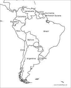
In this blank outline map learning exercise, students explore the political boundaries of South America and the nations there. This map may be used in a variety of classroom activities. The map is labeled with the country names.
Curated OER
South American Outline Map
For this blank outline map worksheet, students study the political boundaries of the continent of North America and those of the countries located there.
Curated OER
Africa Outline Map: Labeled
In this Africa outline map worksheet, students explore the political boundaries of the continent of Africa the countries located there. Each of the nations is labeled on the map.
Curated OER
Mexico and Central America Map
In this blank outline map worksheet, students study the political boundaries of Mexico and Central America. Each of the counties is labeled and the capital cities are starred.
Curated OER
Central America Outline Map - Labelled
In this Central American political map worksheet, students make note of national boundaries and capitals in this region of the world. National capital city locations are noted with stars.
Curated OER
Europe Outline Map (Labled)
In this blank outline map learning exercise, students study the political boundaries of the labeled European nations.
Curated OER
Surveying the Land
Students explore the different kinds of maps and the purpose of each. In this Geography lesson, students work in small groups to create a map which includes the use of a map key.
Curated OER
United States Map - Lesson 4: States
Students use a United States Map to locate their state and use map symbols to determine the boundaries of a state. In this states lesson plan, students learn the definition of a state and identify their own on a map.
Curated OER
The borders of Europe. Geographically location or cultural artifice?
Twelfth graders discuss where they regard the boundaries of Europe to be. They raise their awareness that "Europe" may be more of a cultural construct than geographical defined continent.
Curated OER
The Landscape
Students recognize and recreate the political boundaries and physical features of the nation of Slovakia. They create topographic maps of Slovakia. The maps should include labeled line drawings of bordering countries. Slovakia should be...


