National Geographic
Measuring Elevation Past and Present
After viewing a short video about a climb up Mount Everest, high schoolers read about triangulation for measuring distant elevations. Have your class work in groups to construct an inclinometer and then use it to measure the height of...
Curated OER
Real World Investigation- Math and Geography- Elevation Changes
In this math and geography real world investigation, 6th graders plan a driving trip to a city that is located several states away from their home while recording the elevations of three cities that are included in the trip. They use...
CK-12 Foundation
Elevator
Do you weigh slightly less when an elevator first starts its descent? The simulation teaches the change in the force based on the acceleration, constant speed, or deceleration of an elevator. Scholars control the mass and acceleration...
Mathed Up!
Nets, Plans, and Elevations
A dimensional resource teaches viewers to recognize 2-D views of 3-D objects and how to match nets with their 3-D figures. Individuals draw different views of three-dimensional objects including views from the front, side elevations and...
Curated OER
Extreme Elevations
Seventh graders use highest and lowest points of land elevation around the world to find the differences. Sea level is zero, so students be operating with positive and negative numbers. After students find the information on the...
Curated OER
Contour Map Worksheet #2
Following a contour map of a hill, a stream, and the ocean, are five multiple choice questions. Earth science enthusiasts determine elevation, direction of water flow, distance, and steepness. They also match the map to a selection of...
CK-12 Foundation
Angles of Elevation and Depression: Fly-By Calibration
Determine the distance between two trees from afar. Pupils use an interactive resource to create two right triangles using trees and a plane. They determine the horizontal legs of each triangle to find the distance between the two trees.
Curated OER
European Elevation Sort
Given a prepared database of European countries, sixth graders sort the countries in ascending order by elevation and identify the five countries with the highest elevations. This cross-curricular activity combines elements of computer...
Curated OER
Depression and Elevation Angles
In this angles worksheet, students utilize trigonometry to determine angles of elevation and depression. There are 7 questions and some contain pictures.
Curated OER
Land Elevation
Students investigate land elevation. In this map skills lesson, students use a physical map to identify various elevations of the land. Students find landform features such hills and coastlines.
Curated OER
Angles of Elevation and Depression
In this angles of elevation and depression worksheet, 10th graders solve 4 word problems that are related to determining the angles of elevation and depression. First, they define angle of elevation and angle of depression as used in the...
Curated OER
Elevation at its Peak
Students pretend they are hiking up a mountain. They practice making calculations on angles and elevation. They use topographic maps to estimate distances and trigonometric ratio methods.
Curated OER
Angles of Elevation and Depression
In this angles of elevation and depression worksheet, 10th graders solve 6 word problems that include finding angles of elevation and depression. They solve each problem, rounding the measures of segments to the nearest hundredth and...
Curated OER
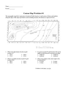
Contour Map Worksheet #1
Being able to read a topographic map is a standard in middle school earth science units and imperative for outdoor enthusiasts. As you introduce learners to this skill, you can assign this as an assessment or reinforcement. Pupils view a...
Curated OER
Topographic Maps
Sometimes it is difficult to grasp topographic maps. Here is a clever presentation designed to help your middle school earth scientists understand. Beginning with a side view of a pair of mountains, a graphic guy walks up one slope. As...
Curated OER
Boiling Point Elevation Problems
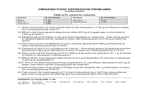
A table of the ebullioscopic constants for several compounds is found at the top of the worksheet. Using these constants, boiling point elevation can be calculated for the combinations of compounds. This worksheet has the answers along...
Southern Nevada Regional Professional Development Program
“Double Double Speak Speak”
Bilateral suborbital hematoma? Call an audible? 404? Have fun with “the twittering or warbling of birds,” or as 14th century French speakers would say, have fun with “jargon.” Groups match specialized jargon with plain speech, decode...
University of Wisconsin
Measuring Slope for Rain Gardens
The slope of the land is an important feature when considering the erosion that will occur. In this resource, which is part of a rain garden unit, learners calculate the slope of the proposed garden site. Even if you are not planning a...
Curated OER
United States Map- Land Elevation
Learners explore a physical map. In this map skills instructional activity, students discuss examples of elevation and investigate the symbols used to identify elevation on a map. Learners use the map to identify various land elevations.
Curated OER
Brain Teaser - Elevator
For this logic worksheet, students solve a word problem using logic about using an elevator to get to certain floors. Students complete 1 problem.
Curated OER
Cookie Topography
Students construct a cross section diagram showing elevation changes on a "cookie island." Using a chocolate chip cookie for an island, they locate the highest point in centimeters on the cookie and create a scale in feet. After tracing...
Curated OER
Applied Trigonometry Problems
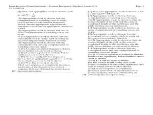
In this applied trigonometry problems worksheet, students solve 12 short answer word problems. Students use trigonometric ratios to find angles of elevation and depression. Students find distances between objects using trigonometric...
Curated OER
Section 8-6: Solving Problems Using Trigonometric Ratios
For this trigonometric ratios worksheet, students solve 20 short answer and multiple choice problems. Students use trigonometric ratios, the angle of depression, and angle of elevation to find missing side lengths of angles of a triangle.
Curated OER
Contour Map Worksheet #4
There are only four questions here. There is a contour map of Cottonwood, Colorado and the creek that crosses it. Earth scientists tell in what direction the creek flows, identify the highest elevation on the map, draw a topographic...
Other popular searches
- Angle of Depression/elevation
- Angle of Elevation
- Elevation Plans
- Boiling Point Elevation
- Elevation Maps
- Land Elevation
- Contour Maps and Elevation
- Elevation Relief Map
- Angles of Elevation
- Elevation Changes
- Map Elevation
- Plans and Elevations


