Curated OER
Oh, the Regions
Focus on the geography of Oklahoma. In this activity, learners compare different geographic regions in Oklahoma, create a collage to share their results, and identify important landforms throughout the United States, such as the Rocky...
Curated OER
Who Are the Aliens in Our Inland Seas?
Students work in teams to research specific landforms in Great Lakes Watershed, compile information into data table, and write legend explaining landform for children's book. Students then research area surrounding landform, compile...
Curated OER
Regions of the United States
Students present a travelogue, an alternate format to preparing their writing, of a specific U.S. geographic region that includes the aspects of population, climate, landforms, economics, culture, famous people and places and natural...
Curated OER
South US Region
In this United States political map learning exercise, students examine the Southern Region state boundaries. The map also highlights each of the state capitals denoted by stars. The states, capitals and major landforms are labeled.
Curated OER
Landforms and Resources of the United States and Canada
For this North American geography worksheet, learners read about the physical features and resources of the United States and Canada. Students take notes and answer 3 short answer comprehension questions as they read the selection.
Curated OER
Regions of the United States
Your learners practice writing ideas on paper and logically presenting them in an organized manner. They brainstorm ways to write down ideas while creating a travelogue about a particular U.S. geographic region. When they present...
Curated OER
The United States and Canada: Climate and Vegetation
Display U.S. and Canadian climate and vegetation through this text-companion worksheet. Learners read about the geography of these regions, take notes, and answer 3 comprehension questions as they read the selection. A graphic organizer...
Ohio Literacy Resource Center
Regions of the United States
Young scholars create a travelogue of a particular U.S geographic region that includes aspects of population, climate, landforms, culture, famous people, and places as well as any natural resources. They present the travelogue to the class.
Curated OER
US: Western Region Map
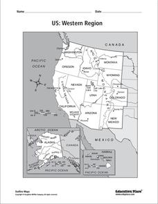
In this United States Western Region worksheet, students examine the state boundaries and landforms found in this region. The map also highlights each of the state capitals.
Curated OER
States and Capitals, Mountains and Rivers
Students identify geographical locations in the midwestern United States. In this geography lesson, students identify 12 states and capitals and geographical features in the region by using U.S. maps. Students use blank maps to fill in...
Curated OER
Fourth Grade Social Studies
In this social studies worksheet, 4th graders complete multiple choice questions about the climate, landforms, regions, government, and more. Students complete 25 multiple choice questions.
Curated OER
Touring the Regions of the United States
Fifth graders explore the regions of the United States. In this geography skills lesson, 5th graders examine the landforms, climates, and economies of the regions of the United States. Students conduct Internet research in order to...
Curated OER
Our Country's Landforms
Pupils investigate the many different landforms that are found throughout the United States. They use the internet and other resources to gather information. The information is used to prepare a multimedia slideshow and to create a...
California Polytechnic State University
Australian Geography Unit
At the heart of this resource is a beautifully detailed PowerPoint presentation (provided in PDF form) on the overall physical geography of Australia, basic facts about the country, Aboriginal history, and Australia culture and lifestyle.
Curated OER
Geography/Current Events Project
Using the Balkan region as an example, fourth graders review the five themes of geography as a class. They identify the physical and human characteristics of a region before labeling the countries and landforms on a map. They then...
Curated OER
Geography and Culture in South Carolina
Students explore South Carolina. In this cultural heritage instructional activity, students investigate the topography of South Carolina using maps. Students are engaged in identifying the different regions of the state and examine the...
Curated OER
Let's Look at Legends: Oregon quarter reverse
Analyzing historical legends is a fun way to develop critical-thinking skills. Pupils will use a graphic organizer to compare and contrast two historical legends relating to volcanoes. While this activity focuses on the image of Crater...
Curated OER
Salt Relief Map of Virginia
Fourth graders create a salt relief map of the four regions of Virginia. They indentify land forms and bodies of water, and summarize how they made their project.
Curated OER
California Regions
Students explore and compare and contrast the four main regions of California: mountains, coast, central valley, and desert. students use pictures and research to describe how regions vary in land use, vegetation, wildlife and climate.
Curated OER
California Poppy Postcards
What a great lesson! Learners discuss California history, including the state flower, the poppy, and then engage in an art activity. For the activity, they learn about value, shading, layering, blending etc. to produce a realistic...
Curated OER
The Edge of the Lake
Second graders explore the geography of Nevada. In this map-making lesson, 2nd graders use salt dough to create a relief map of Nevada. Students label the landforms and bodies of water that are studied and specified in the lesson.
Curated OER
MAISA and the REMC Association of Michigan
Students complete online research to study geography's impact on weather. In this geography and weather lesson plan, students research weather in their city for ten days using an online website. Students bookmark the site, enter data...
Curated OER
Country Landform Brochure
Third graders create brochures that include landforms, natural resources and pictures of a country that has been researched or studied in class.
Curated OER
The 1927 Flood
Upper elementary and middle schoolers examine the Great Flood of 1927 in the state of Arkansas. They each prepare an oral report about this flood and the huge impact it had on the economics of that time. Additionally, learners research...


