Curated OER
Globe Lesson 10 - Latitude Zones - Grade 6+
In this latitude zones worksheet, middle schoolers read a 1-page review of latitude zones and respond to 7 short answer questions regarding the low, middle, and high latitude zones.
Space Awareness
The Intertropical Convergence Zone
Young scientists know it is hotter along the equator, but why is it also rainier? Through the process of completing two experiments and a worksheet, scholars discover the answer is the intertropical convergence zone. First, they...
NASA
Analyzing Surface Air Temperatures by Latitude: Student Activity
Explore global temperatures from the comfort of your learning place! Meteorologists analyze surface temperatures and anomalies across different latitudes. Investigators evaluate graphs to find temperature differences and answer questions...
Curated OER
Time Zones
Students solve time zone problems and chart travel around the world. In this time zone lesson, students learn about the history of time zones and view a time zone map. Students use the time zone map to solve time zone problems. ...
Curated OER
Where in the Latitude Are You? A Longitude Here.
Students distinguish between latitude and longitude on the map. In this mapping lesson, students participate in mapping skills to recognize spatial relationships, and where to find natural resources on the map. Students create their own...
Curated OER
Lesson 1 Activity 1: Tools of the Ancients
Students examine how Christopher Columbus determined his latitude.
Curated OER
What Time Is It? (Latitude and Longitude)
Students practice latitude and longitude by identifying locations by degrees, use meanings of a.m. and p.m. appropriately, become familiar with 24-hour (universal) clock, and calculate time at different degrees longitude.
Curated OER
Climatic Zones
Third graders recognize and locate Frigid, Temperate, and Torrid climatic zones on the word map or globe. They explain that plants, animals, and human societies display adaptations to the climates they live in .
Curated OER
Plotting Earthquakes and Volcanoes
In this earthquakes and volcanoes worksheet, learners are given the latitude and longitude of earthquakes and volcanoes and they plot them on a world map. They answer questions based on their results.
Curated OER
Viewpoints
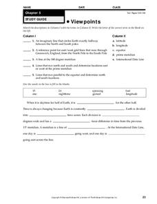
In this latitude and longitude worksheet, students complete 10 matching questions identifying key features or locations on a map. Students also use lines of latitude and longitude to identify the time in 4 different places.
Space Awareness
Climate Zones
The climate at the equator is hotter than the climate at the poles, but why? The lesson goes in depth, explaining how the angles of illumination relate to the heating rate at different latitudes and seasons. Scholars use a strong lamp,...
Curated OER
Understanding Latitude, Longitude, and Time Zones
Students take an imaginary world tour by locating cities with latitude and longitude. They plan an itinerary and calculate the time zones from which they would call home. Then they construct word problems involving travel across time zones.
Curated OER
Maps: Latitude and Longitude
Students visit interactive sites focusing on latitude and longitude. They participate in activities about the prime meridian, time zones, and equator. They view the coordinates of states and cities.
Curated OER
Latitude and Longitude
Learners find latitude and longitude on a map or atlas. They create maps with a cruise route. They practice plotting locations given latitiude and longitude.
NOAA
A Watery World
With about 70% of the earth's surface covered in oceans, it's fair to say that we live in a very wet world. Young scientists gain a better appreciation of this fact as they use maps to identify the world's ocean basins in the first...
Mr. E. Science
Climate and Climate Change
What factors make up climate? How does longitude and latitude affect climate? What is causing Earth's climate to change? These questions are the topic of a presentation that explains characteristics of climate and climate change.
Curated OER
Viewpoints
In this map learning exercise, students review latitude, longitude, equator, and prime meridian. This learning exercise has 5 matching and 8 fill in the blank questions.
Curated OER
Maps, Charts, and Graphs
Students define key geographic terms and track a hurricane on a map. They examine various types of maps and find locations on them,including rivers, cities and mountains.
Curated OER
World Climate Growing Zones
Students create a map showing where crops would be grown around the world. In this crops lesson plan, students show how the world climate would produce different parts of the world at different times. Students fill out worksheets.
NOAA
Ocean Layers II
Now that you know the ocean has layers, let's name them. The seventh installment of a 23-part NOAA Enrichment in Marine sciences and Oceanography (NEMO) program covers terminology associated with ocean layers, such as thermocline and...
Port Jefferson School District
Climate Patterns
Young climatologists explore the factors that contribute to a region's climate in this two-part earth science activity. To begin, learners are provided with a map of an imaginary planet and are asked to label global wind and ocean...
PBS
Ocean Circulation in the North Atlantic
Swirling and churning, the waters of the North Atlantic play a vital role in Earth's climate! Discover the many factors that produce circulation using a multimedia lesson from PBS's Weather and Climate series for high schoolers. Scholars...
Curated OER
Plate Patterns
Learners read about a volcano and use the latitude and longitude information to plot and describe the volcano on the map. They discuss patterns seen on the map. In addition, they color code a map according to zones, plates, etc.
Curated OER
Using Vegetation, Precipitation, and Surface Temperature to Study Climate Zones
Students begin their examination of the climate zones found around the world. Using a software program, they identify the relationship between the vegetation, climate and temperatures of the different zones. They also plot coordinates...


