Curated OER
Maps and Globes: Where in the World are We?
Students explore maps and globes. In this introduction to map and globe concepts lesson, students identify features of physical maps, political maps, and globes. Students locate land and water, and recite a poem about the names of the...
Curated OER
Water Features - Lesson 2 - U.S. Political Map Grade 4-5
Students locate water features on maps. In this geography lesson plan, students complete worksheets that require them to identify water features on a U. S. political map.
Curated OER
Africa: Political Map
Students create a political map for Africa. For this country identification lesson, students locate Africa on a globe and discuss some of its major countries and bodies of water. Students complete a political map of Africa and test...
Curated OER
U.S. Political Map
Students explore the symbols found in a map legend. In this map skills lesson, students locate the legend on a political map and explain what each of the symbols mean. Students locate and identify several symbols on the map.
Curated OER
Africa Political Map
In this blank outline map worksheet, learners explore the political boundaries of the continent of Africa, the countries located there, and label other geographic features.
Curated OER
Map Keys
Third graders examine maps and map keys. In this locating map features instructional activity, 3rd graders use crayons, markers and colored pencils to label maps. Students work in partners to read map keys and locate given places and...
Curated OER
Fourth Grade Social Studies
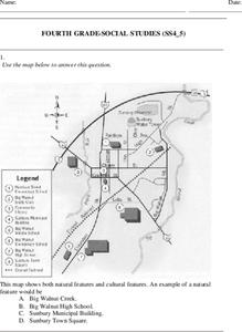
In this social studies worksheet, 4th graders answer multiple choice questions on state maps, city maps, road maps, political maps, and more. Students complete 25 multiple choice questions.
Curated OER
Map It!
Fourth graders demonstrate map making skills by using the computer to create maps of the geographic features, regions, and economy for their state.
Curated OER
United States Map- Map Legend/City Symbols
Young scholars investigate the United States map. In this map skills geography lesson, students explore city symbols on the map legend and identify them. Young scholars use post-it notes to mark various symbols.
Curated OER
Mapping the News
Students explore cartography. For this map skills and map making lesson, Students work in groups to create wall size world maps including legends, compass roses, latitude and longitude, and physical features. Students collect current...
Curated OER
Mapping the Census
Students learn why the census makes a difference. In this U.S. Census lesson plan, students learn the key elements of cartography, examine the difference between data and their representation, and create a map using census data.
Curated OER
Cartoon and Political Poster Analysis
Learners explore the late 1800s as a time of demographic change in the US. They view the role of media during this time in the form of posters and political cartoons. They create a political poster/cartoon that deals with current...
Curated OER
Mapping Where Animals Live
What type of reptiles live in New York State? This instructional activity gets the class thinking about what factors determine where particular animals live. They analyze the Hudson Valley environment, identify specific reptile and...
Curated OER
Create a Country
Students work in small groups to list features and elements found on a variety of grade- appropriate maps. They develop a class list of map features and elements to draw from as they create a map of an imaginary country.
Curated OER
Waldseemuller's Map: World 1507
Students investigate the 1507 word map. In this world geography activity, students examine the details of each section of the map and then draw conclusions about how the people of 1507 understood the world. Students are evalated on...
Curated OER
Understanding "The Stans"
Students explore and locate "The Stans" in Central Asia to create, write and illustrate maps, graphs and charts to organize geographic information. They analyze the historical and physical characteristics of Central Asia via graphic...
Curated OER
United States Map
Students describe cities they are familiar with. In this United States Map lesson, students understand how cities are listed on a map. Students become aware of a map legend and the information in it.
Curated OER
Waldseemüller’s Map: World 1507
Students take a closer look at historical maps. In this primary source analysis lesson, students examine the first world map produced by Martin Waldseemuller. Students complete the included map analysis worksheet and then write letters...
Curated OER
Map Reading in the 21st Century
Students interact with MapPoint tools to view maps of the past and the present in multiple ways. They participate in mini-lessons aimed at locating certain points of interest or famous routes taken in history.
Curated OER
Map Activities
In this geography worksheet, students follow the directions and shade 3 different regions of a UK political map, shade European Union countries on a political map of Europe, match 4 physical feature of Africa to their descriptions, and...
Curated OER
Map It!
Fourth graders collect and explore different maps and their uses before using the program Pixie to create maps of geographic features, political features, and economic information for the state in which they live.
Curated OER
Map It With Pixie
Fourth graders use the computer program 'Pixie' to create a topographic, detailed map for the state they live in. In this mapping skills lesson plan, 4th graders use Pixie to make a map of their state that includes topographic features,...
Curated OER
The Sands of Arabia
Sixth graders apply geographic information to the study of World History. For this Geography lesson, 6th graders create a political/physical map of the Middle East, develop questions and answers about the culture of the Middle East, and...
Curated OER
Summertime Travel
Third graders write about a summer event they participated in. In this paragraph writing lesson, the teacher models how to write about a place they have visited. Students then write their own paragraphs. Students will point out on the...


