Curated OER
Mapmaker, Make Me a Map!
Here is a well-designed, very thorough lesson plan on mapping for very young children. Within the six-page plan, you will find everything you need to implement the activity. They will identify various landforms found in Colorado on a...
Curated OER
Colorado Map
In this state maps worksheet, students identify the state of Colorado, and fill in the state capital, major cities, and other attractions for the state.
Curated OER
Probability and the U.S. Map
Learners solve and complete 20 different problems that include using a U.S. map and data table. First, they calculate the probability that they will select a state that begins with each letter of the alphabet. Then, everyone completes...
Curated OER
The Geography of the United States
Full of bright maps and interesting information, this presentation details U.S. Geography. Slides include basic facts about size, regions, topography, and demographics, as well as fascinating trivia about the United States, including...
Curated OER
Name the States Worksheet 1
In this name the states worksheet, learners examine 6 state map outlines and identify each of them by writing the state names and postal abbreviations.
Curated OER
Play Doh Map of Your State
Students create a state map using Playdoh. In this hands-on state geography lesson, students work in groups to form a three-dimensional map of their state using Playdoh made at home following a (given) recipe. Students use four colors...
Curated OER
Do You Know Your 50 States?
Learners use the names and abbreviations of the 50 states to label a blank map of the United States.
Curated OER
Utah: State History
For this Utah state history worksheet, students read two and a half pages of information about Utah and complete 10 true and false questions.
Curated OER
United States Map Quiz
In this online interactive geography quiz worksheet, learners respond to 50 identification questions about the shapes of countries shown. Students have 5 minutes to complete the quiz.
Curated OER
Controlling the Flow of the Colorado River: A Study of Dams
Students research and map the Colorado River and its dams and predict the effects of a dam on an area. They suggest reasons a dam would be built and compare the Colorado River system with other major river systems within the US and...
Curated OER
Colorado
Third graders complete a variety of activities to increase their knowledge of Colorado. They make leafprints, read and listen to stories, write fiction, make collages, participate in discussions and invite their parents to come and see...
Curated OER
Colorado Outline Map
In this Colorado outline map worksheet, students examine political boundaries of the state and the placement its capital city as well as its major cities. This map is not labeled.
Curated OER
What Can We Discover About Colorado?
Young scholars locate Colorado and its neighbors on a map (either in a book or on the Internet). They create a graphic that illustrates what they know and want to know about the state (KWL); finally, they draw and label Louisiana maps.
Curated OER
Mystery State #16
In this mystery state worksheet, students answer five clues in an attempt to identify the state in question. Then, students locate it on a map.
Curated OER
States in the USA Quiz
For this online interactive geography quiz worksheet, students respond to 50 identification questions about the states in the United States of America. Students have 4 minutes to complete the quiz.
Curated OER
17 states
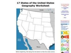
In this states learning exercise, students label states in the United States that are on the west side of the country. Students label 17 states.
Curated OER
Mystery State #11
In this United States mystery worksheet, learners determine which state is described by the 5 clues listed on the sheet and then mark it on the outline map of the United States.
CK-12 Foundation
Regular and Irregular Polygons: Polygon States
Colorado would probably object if Wyoming enlarged its borders. Scholars use an interactive map to change the borders of U.S. states to see how angles change. They then answer questions about regular and irregular polygons.
Curated OER
Mapmaker, Make Me a Map!
Students are introduced to the state quarter program and examine the Colorado state quarter. They locate Colorado on a map and create a map with a key. They discuss the state motto and examine pictures of the state's geographical features.
Curated OER
Colorado Greats Trading Cards
Students research to find information about famous people from Colorado. They copy and save pictures from the Internet, then make a trading card containing important biographical data.
Curated OER
Mapping the United States
For this map of the United States worksheet, learners label mountains, surrounding countries, oceans, and more. Students complete 12 tasks.
Curated OER
Mexico: One Land, Many Cultures
Students, through a variety of activities, discover the geography and culture of Mexico. They make maps, read folktales, write a journal, create pinatas and other artistic pieces, and review the history of Mexico.
Curated OER
Fourth Grade Social Studies
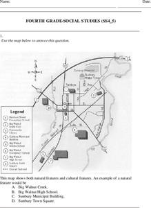
In this social studies worksheet, 4th graders answer multiple choice questions on state maps, city maps, road maps, political maps, and more. Students complete 25 multiple choice questions.
Curated OER
Spanish Influence in the U.S.
Eighth graders research the role of the first Spanish conquistadors who explored the now United States. Using the internet, they gather information on different explorers and write a paper about why he is important in American history. ...


