Curated OER
United States Regions
For this United States political map worksheet, students examine regional census boundaries of the US. State boundaries are also included.
Happy Housewife
State Notebooking Pages
When learning about US geography, it can hard to remember facts about 50 different states. Help your young scholars organize all of this information with a collection of easy-to-use note-taking guides.
Curated OER
The Geography of the United States
Full of bright maps and interesting information, this presentation details U.S. Geography. Slides include basic facts about size, regions, topography, and demographics, as well as fascinating trivia about the United States, including...
Judicial Learning Center
State Courts vs. Federal Courts
Popular culture often portrays the Feds as the most fearsome of law enforcement agencies. Yet, someone charged with a crime is considerably more likely to end up in a state court. The lesson, one of six covering the Organization of the...
Curated OER
The United States and Canada: Climate and Vegetation
Display U.S. and Canadian climate and vegetation through this text-companion learning exercise. Learners read about the geography of these regions, take notes, and answer 3 comprehension questions as they read the selection. A graphic...
Curated OER
Regions of Virginia
In this geography worksheet, 5th graders identify the regions of the state of Virginia and sort them according to location. Then 10 questions focus upon the specifics of different regions.
Ohio Literacy Resource Center
Regions of the United States
Young scholars create a travelogue of a particular U.S geographic region that includes aspects of population, climate, landforms, culture, famous people, and places as well as any natural resources. They present the travelogue to the class.
Little 10 Robot
Geography Drive USA™
A trivia-style virtual road trip in which the player's car is moved from state to state as questions are correctly answered. Ideally, a player would learn about different states by reading the simple brochures available in the...
Curated OER
Oh, the Regions
Focus on the geography of Oklahoma. In this activity, learners compare different geographic regions in Oklahoma, create a collage to share their results, and identify important landforms throughout the United States, such as the Rocky...
Curated OER
The 50 States
Fifth graders use a database to gather information on the United States. Using this information, they try to describe the settlement patterns in the various states. They enter additional information into the database and use queries to...
Curated OER
Puerto Rico: The 51st State?
Learners research the history of Puerto Rico, its culture, and geography. In this Puerto Rico lesson, students find Puerto Rico on a map and find specific regions or cities. Learners discuss Puerto Rico's statehood and listen to salsa...
Curated OER
Basic U.S. Geography
Provide your 11th graders with a basic understanding of U.S. Geography. They label the state, regions, and boundaries found in the contiguous U.S. as well as Hawaii and Alaska. Then, they complete two Internet related activities.
CK-12 Foundation
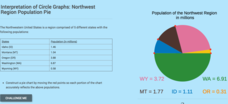
Interpretation of Circle Graphs: Northwest Region Population Pie
Given populations of the five Northwestern states, learners create a circle graph. Using the data and the pie chart, they make comparisons between the populations of the states. Finally, the pupils determine how the chart will change...
Curated OER
Places in Arkansas: A Tour of Our Unique State
A great lesson focuses on important cultural and historical places in the state of Arkansas. Learners are introduced to six important places in Arkansas, then create a report on a place in Arkansas. Some excellent photographs, resource...
Curated OER
Jeopardy Game: Kentucky
As part of a unit on states in the U.S., this resource could be used as an independent activity. Students could play this jeopardy game relating to Kentucky at a center to practice information they had learned. This engaging game could...
Curated OER
US: Midwest Region
In this United States political map worksheet, students examine the state boundaries of the Midwestern Region. The map also highlights each of the state capitals denoted by stars.
Curated OER
US: Northeast Region Map
In this United States political map worksheet, students examine the state boundaries of the Northeast Region. The map also highlights each of the state capitals denoted by stars.
Curated OER
US: Northeast Region: Unlabelled
In this United States political map worksheet, students examine the Northeast Region state boundaries. The map also highlights each of the state capitals denoted by stars.
Curated OER
Social Studies: Looking at Regions
Quiz your 3rd graders on why we have regions. This regions quiz includes 16 questions on why and how we group areas into regions based on physical features, culture, politics or religion. A class discussion on technology completes this...
Curated OER
US Geography: The Midwest
Learners investigate the geography and agricultural products of the Midwestern United States. In this US geography lesson, students watch and discuss a video that depicts the Midwest of the US as the breadbasket of the country. They make...
Curated OER
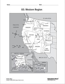
US: Western Region Map
For this United States Western Region worksheet, learners examine the state boundaries and landforms found in this region. The map also highlights each of the state capitals.
US Department of Commerce
How Are Single-Parent Households Distributed Across the United States?
There sure are a lot of single-parent households in the country. After selecting one of four US regions to investigate, pupils create dot plots and box plots on the percentage of single-parent households with male parents and female...
Curated OER
US Policy In Somalia
Students investigate the US policy for the country of Somalia. They conduct research using a variety of resources. They locate the country and then discuss major geographical features of the areas. Students discuss the present US...
Curated OER
My State of the Union
Fourth graders, in groups, research states and using various print and nonprint reference materials. The groups make a presentation to inform the class about all the information from the state. This lesson plan provides imbedded support...


