Curated OER
Map Keys
In this geography worksheet, students identify who a cartographer is and what they do specifically. They study an outline map of a fictitious island and then, respond to the three questions that follow. Finally, students add three more...
Curated OER
The Mother Culture of Mexico: The Olmecs
Sixth graders study the Olmec civilization. They develop a map of Mexico and a map of the area of the Olmec civilization. They research Olmec art, religion, and architecture. They construct Olmec symbols including giant heads, altars,...
Curated OER
Lake Tahoe Then and Now
Young scholars investigate the differences in Lake Tahoe from the past to the present. In this geography lesson plan, students read the book Washoe Seasons of Life and identify the descriptions of the land and lake. Young scholars create...
Curated OER
Site and Situation: Right Place at the Right Time
Young scholars put their geography skills to work. In this geography skills lesson, students research maps and other primary and secondary sources to simulate the site selection process for the Pennsylvania Railroad Shops post World War...
Curated OER
Asia's Global Influence
Middle schoolers explore Hong Kong. In this geography skills lesson, students watch "Asia's Global Influence," and then research the culture, landmarks, and geographic features of Hong Kong. Middle schoolers use their research findings...
Curated OER
Global Intelligence
Students discuss the war in Afghanistan and the conditions surrounding the hunt for Osama bin Laden after reading the article "Bin Laden and Omar: Far Harder to Find" from The New York Times. After the class discussion, students...
Curated OER
Putting the World in Perspective
Students work in small groups to: make a mental map of the world by tearing paper shapes of the seven continents and locating them on a flat surface in their relative positions, compare their finished mental map to a reference world map,...
Curated OER
Where We Live
Students forecast future population growth of the U.S. Virgin Islands. In this U.S. Census lesson plan, students explain the factors that influence population density on the U.S. Virgin Islands, including geography and economic activity.
Curated OER
Hide and Seek with Geocaching
Students locate objects using a Global Positioning System. In this global geography lesson, students explore latitude and longitude using a GPS in order to locate objects.
Curated OER
The Equator
Learners investigate cultures located along the equator. In this geography skills lesson, students research the geography, history, culture, and tourism of Ecuador, Indonesia, Kenya, Brazil, and Singapore. Learners write an article based...
Curated OER
Mapping South America
Middle schoolers explore South America. In this South American lesson, students use their geography skills to create population, terrain, biomes/vegetation, and major exports maps. Middle schoolers present their finished maps to their...
Curated OER
Regions Change
Students examine how geography can have an impact on change in a region. They discuss what their local area might be like in 50 years, and in pairs, select a situation and write a short story to describe how it changed from one thing to...
Curated OER
Sacred Sites
Learners read about the one-year anniversary of the bombing of the Mosque of the Golden Dome, or Askariya Shrine, in Iraq. They explore a number of other sites of religious significance to create designs for a geography Web site on holy...
Curated OER
American Indians and Their Environment
Learners create a storyboard of the three American Indian language groups showing the geography of where they lived and how they adapted to the environment. They compare European and American Indian views of nature and explain how these...
Curated OER
Feral Cats
In this geography worksheet, students identify the feral cats of Australia. They read an excerpt and respond to the three questions that follow. Students also imagine that they are a part of scientific team that has been set up to deal...
Curated OER
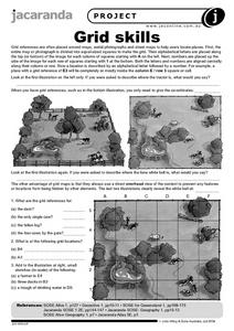
Grid Skills
In this geography worksheet, students use grid references on a map to locate places in the pictures given. They also identify another advantage of using a grid map, which they have an overhead view of the content to prevent any features...
Curated OER
Chinese Lion Dance
Students celebrate the Chinese New Year and listen to the story behind the Chinese Lion Dance. In this Chinese New Year lesson, students research the geography and culture of China. Students create puppets, dance the Lion...
Curated OER
What in the World Is a Watershed?
Students discover the role of a watershed. In this geography instructional activity, students are shown a diagram of a watershed and discuss the definition of a watershed. Students demonstrate the role of a watershed by using an umbrella...
Curated OER
Reporter's Notebook
Students research the geography and history of a major city in Iraq. They write a journal from the perspective of a war correspondent stationed in that city.
Curated OER
Mesopotamia
Students map Mesopotamia. In this Geography lesson, students are introduced to Ancient Mesopotamia. Students use an atlas to label the defining features and areas of Mesopotamia on a map.
Curated OER
Waldseemuller's Map: World 1507
Students investigate the 1507 word map. In this world geography lesson, students examine the details of each section of the map and then draw conclusions about how the people of 1507 understood the world. Students are evalated on...
Curated OER
Old Kids From The Bloc
Students study about wide scale construction and development in Moscow and its impact on cultural and historic preservation. They research the political, social, economic, and cultural changes in the former Eastern Bloc and create a...
Curated OER
In Search of Truce
Students explore the relationship between a country's political and social history and its position today. They study 8 African countries immersed in the present conflict in Congo. They present their findings.
Curated OER
Countries of South America
Middle schoolers focus on the geography of the countries of South America. Using a map, they identify the European countries who claimed the South American countries and research the influences they had on South America. To end the...


