Curated OER
Topographic Connections: Earth's Surface Shapes Streams; Streams Sculpt the Earth
Learners identify physical characteristics of developing streams and infer changes in the landscape by creating a river model.
NET Foundation for Television
1850-1874 Railroads and Settlement
Have you ever wondered how your town was placed where it is? Scholars research the impact the advancement of the railroad due to the passage of the Kansas-Nebraska Act had on the formation of civilization in the Great Plains. Map...
Curated OER
A Passage Through Time
Young learners research and present information about a chosen subject to their peers, parents, instructors, and community. This lesson has a strong research and public speaking component, and would be ideal for your higher level students.
Curated OER
Survival of Native American Culture
Students research the five tribes of the Iroquois Nation focusing on housing, food, clothing, transportation, religion, and language. They research using Internet sources and book mark sites for reuse.
Curated OER
Rockin' Round New York State
Students discuss their favorite rock groups and bands. They create rock groups that will be touring New York State. Students research cities in New York, determine dates of concerts, create touring itineraries, and develop Inspiration...
C-SPAN
Political Polarization
Dive into the political breach with pupils and explore the reasons for political polarization. Using clips from C-SPAN that include discussions from reporters and scholars, class members consider what is causing the political fault lines...
Curated OER
Examining What Sharing Really Means
Learners read "The Senegalese Miracle". They discuss the amount of sharing the author finds in Africa. They examine the relationship the author has to the locals.
NET Foundation for Television
1850-1874 Homestead Act Signed: The Challenges of The Plains
Start a whole new life in a land known as the Wild Wild West! Learners analyze maps, personal accounts, the Kansas-Nebraska Act, songs, and video clips to uncover life under the Homestead Act. Using their new skills, class members role...
Curated OER
Tears of Joy Theatre Presents Anansi the Spider
Accompany the African folktale, Anansi the Spider, with a collection of five lessons, each equipped with supplemental activities. Lessons offer multidisciplinary reinforcement in English language arts, social studies, science,...
Curated OER
The Fabric of Our World
Students discuss cultural diversity, and examine how the community reflects the cultural background of the inhabitants. They read the book, People, take a community walk, create a rainbow chart, and research other states for relocation...
Curated OER
Human Impacts on Major Rivers of the World
Students explore motivations behind human intervention in the stream flow of selected rivers, infer kinds of interventions and their results, and evaluate level of success of such interventions of stream flow as well as environmental...
Owl Teacher
Latitude & Longitude
Here is a worksheet activity where learners mark the latitude and longitude coordinates of cities all over the world. There are 15 cities to identify, from Baghdad, Iraq to Warsaw, Poland and Anchorage, Alaska.
Curated OER
Geography Lesson 2
Students interpret photographs and search for common and opposite cultural and physical aspects of countries, and create a collage for an "ideal" country.
Curated OER
Studies of the Ancient World
Sixth graders, after taking a pretest, write a paragraph describing the difference between Athens and Sparta and write an article about the ancient Phoenicians, describing their contributions to world history. They compare democracy in...
Curated OER
Europe Map
In this world geography worksheet, learners study the map of Europe and locate the 48 countries within the continent. Students write the names on the provided lines.
Curated OER
GeoHive Information Hunt
In this geography skills worksheet, students respond to 30 short answer questions about world geographic features and locations.
Curated OER
Geography of the Roman Empire
Students explore the Roman Empire. In this ancient Rome lesson, students research regions of the Roman Empire and present their finding to their classmates. Students also use an interactive map to practice placement of the regions within...
Curated OER
Blank Map of Canada
In this Canadian geography worksheet, students use a blank map of Canada to color and label important geographical features and cities. Students will need to do their own research before labeling this map.
Curated OER
North America
In this map of North America worksheet, students study the map of North America and then write the names of the 11 countries on the provided lines.
Curated OER
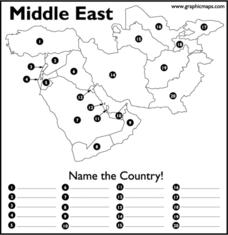
Middle East
In this map of the Middle East worksheet, students study the map of the Middle East and then write the names of the 20 countries on the provided lines.
Curated OER
What You Can Learn From a Map
Students discover how to interpret maps. In this geography skills lesson plan, students explore geographic themes as they complete worksheet activities regarding road maps, shaded relief maps, and topographic maps.
Curated OER
Locations Of Countries In Europe
In this European geography worksheet, students describe where 12 countries in Europe are located by using directional phrases. Students also practice describing the nationalities of people from each country and how to pronounce each...
Curated OER
Where Does It Belong? The Climate Regions of Africa
In this African geography worksheet, middle schoolers read about the land and climate of 6 African countries. Students then complete a graphic organizer about the 5 climate regions of Africa and respond to 2 short answer questions.
Curated OER
Map Activities
In this geography learning exercise, students follow the directions and shade 3 different regions of a UK political map, shade European Union countries on a political map of Europe, match 4 physical feature of Africa to their...


