Curated OER
Maps and Globes: Where in the World are We?
Students explore maps and globes. In this introduction to map and globe concepts lesson, students identify features of physical maps, political maps, and globes. Students locate land and water, and recite a poem about the names of the...
World Maps Online
Introduction to the World Map
Students identify the differences between maps and globes. In this map skills instructional activity, students are shown a globe and a map and recognize the differences. Students use post-it notes to locate several locations on the world...
Curated OER
Countries of the World
Learners identify countries on a world map. In this map skills lesson, students define the word "country" and use post-it notes to locate several countries on a world map.
Curated OER
Equator, North Pole, and South Pole
Students identify the Equator, North Pole, and South Pole on the globe. In this map skills lesson, students use a globe marker to locate specific locations on the globe. Students find where they live in relation to the Equator.
Curated OER
Country Capitals
Students locate country capitals on a world map. For this map skills lesson, students review the definition of the word country and discuss what a capital is. Students locate and label capital cities on a world map using a map marker.
Core Knowledge Foundation
Thanksgiving with the Pilgrims
Teach kindergartners about the First Thanksgiving with a series of lessons about the Pilgrims' journey to the New World. As they practice handwriting, CVC words, reading comprehension, and fun Thanksgiving songs, they learn about what...
Curated OER
The Ancient Civilization of Mali
Learners explore the ancient civilization of Mali and examine various historical and cultural aspects of the civilization. In this ancient civilization of Mali instructional activity, students examine trade with respect to geographic...
Curated OER
Identifying Island Countries
Students discover the definition of an island and identify island countries around the world. In this geography lesson, students determine the characteristics of an island. Finally the students will identify specific island countries,...
Curated OER
Foods and Languages of the World
Young scholars review Mexico's location and language and learn to pronouns 10 new Spanish food words. Students listen as the book, Corn is Maize is read, touching and passing around an ear of Indian corn. Young scholars discuss the...
Curated OER
Our Way of Life
Students interview Native American Elders about animal migration, traditional food gathering, and subsistence. They research endangered animals, draw a game cycle, and create maps of local migration of animals.
The Newberry Library
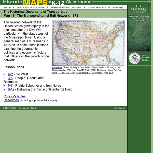
Newberry: Historical Geography: Map 11: The Transcontinental Rail Network, 1878
Lesson for K-12 using historical maps examine the geographic, political, and economic factors that influenced the growth of railroads.
The Newberry Library
Newberry: Political and Military History: Map 15: The World at War, 1944
Lesson for K-12 using historical map teaches students about the relationship between perspectives of the world and map projections.
Other popular searches
- Political Map of World
- Blank World Political Map
- World Political Map Labeled
- Political Map of the World


