Curated OER
Deep Blue: Exploring the Deep Ocean
Students examine landforms. In this social studies lesson, students bounce a beach ball around in order to discover that seventy percent of the Earth is covered in water. Students
Curated OER
Capitals, Oceans, And Border States
Students investigate geography by completing games with classmates. In this United States of America instructional activity, students examine a map of North America and identify the borders of Mexico and Canada as well as the Pacific and...
Curated OER
Thematic Unit on Cats
Students discover in which climates the cats of the world live in. They review the different climates of the world and use maps and globes to help them locate continents.
Curated OER
Water
Students complete activities to examine the properties of water. In this water science lesson, students read a book about water's forms and study a map or globe of the Earth to investigate water. Students discuss living things that need...
It's About Time
Effects of Plate Tectonics
Explore our world from within as you lead young scientists on a thrilling adventure. Pupils examine the location of plate boundaries to determine earthquake and volcano distribution around the globe and explore the cause of hot spots in...
Curated OER
The Prairie Climate
Ninth graders research the average temperature and precipitation of a prairie region to determine the type of climate it is, and how it differs from other biomes. They examine the types of adaptions animals have made to live in the...
Curated OER
COLD SEA WATERS
Students examine how old sea waters affected the local and state area during the summer of 1998. Studying a detailed web-site helps students examine sea temperatures.
Curated OER
Celebrating the Solstice and Equinox
Fourth graders graph the number of daylight hors throughout the year and examine why day length varies. They discover that seasonal changes and latitude on Earth affect the number of hours of daylight in each day. Students listen to...
Howard Hughes Medical Institute
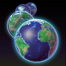
EarthViewer
Can you imagine Washington DC and London as close neighbors occupying the same continent? Learners will be fascinated as they step back in time and discover the evolution of the earth's continents and oceans from 4.5 billion...
Curated OER
Wolves: Friend or Foe?
Students study wolves and their habitat in Yellowstone. In this environment and behavior lesson students create an interactive map of wolves in Yellowstone.
Curated OER
War of 1812
Eighth graders locate the major land forms and bodies of water on a map of Louisiana. In groups, they discuss the role of the Mississippi River in the Battle of New Orleans and how land and water affect the outcome of battles. To end...
Curated OER
Using Vegetation, Precipitation, and Surface Temperature to Study Climate Zones
Students begin their examination of the climate zones found around the world. Using a software program, they identify the relationship between the vegetation, climate and temperatures of the different zones. They also plot coordinates...
Curated OER
Analysis of Atmospheric Conditions for a High Mountain Retreat
Students examine the relationship between altitude, atmospheric pressure, temperature and humidity at a particular location. They practice science and math in real world applications. They write reports detailing their scientific...
Curated OER
High Mountain Retreat
Students explore and analyze atmospheric conditions for a high mountain retreat. They examine the relationship between altitude, atmospheric pressure, temperature and humidity at a particular location. In addition, they write reports...
California Polytechnic State University
Australian Geography Unit
At the heart of this resource is a beautifully detailed PowerPoint presentation (provided in PDF form) on the overall physical geography of Australia, basic facts about the country, Aboriginal history, and Australia culture and lifestyle.
Curated OER
Landforms
Students begin their examination of landforms. Using a map, they locate and identify the major landforms on Earth. They discuss how landforms affect the lifestyle of the community and determine which goods and services the community...
Curated OER
Primary Sources and Archaeology in the Study of Ancient Mediterranean Trade
Tenth graders begin the lesson by plotting trade routes, major empires and items traded. Using primary sources, they examine their own values regarding trading items for royality. They participate in a role-play exercise in which they...
Alabama Learning Exchange
Coral Reefs
Study explore coral reefs. In this coral reef lesson plan, 4th graders examine the physical structure of coral reefs. Students consider why coral reefs need to be protected and ways to protect them.
Curated OER
Water Quest
Students visit the Hydrology Study Site, conduct a visual survey to discover info about local land use and water quality, and document their findings by mapping the water body. They use this investigation to raise questions for further...
Curated OER
Building Bridges for Young Learners - Self
Students explore self analysis by investigating other cultures. In this personal characteristics lesson, students utilize the Internet to read about a child from Niger, and many other students around the globe. Students compare their own...
Curated OER
Afghanistan and The Breadwinner
Pupils examine the use of the Hindu Kush mountains by explorers and traders. Using Afghanistan as an example, they research how different events can effect human settlerment patterns. They discuss how the physical characteristics of an...
Curated OER
If You Build It, Will They Come?
Students examine the city of Duluth, Minnesota. In groups, they use the internet to discover its current state of urban geography. After their research, they create and plan their own redeveloping of the city. They share their results...
Curated OER
Where in the World Am I?
Students are introduced to geography skills. They answer questions on a worksheet using the internet and maps. They examine the area of Japan as well.
Curated OER
Patchwork of the Planet
Students are taught how satellite images can be joined to make a picture mosaic. They use actual satellite images to make satellite mosaics regions of the United States. Students use a camera to photograph portions of a globe in the...


