Teach Engineering
Using Map Scales to Figure Distances and Areas
The asteroid is getting closer and the question is whether the state of Alabraska is large enough for the shelter calculated in the previous activity. Teams determine the scale of their project and then use the scale on the map to...
Curated OER
Scale/Ratio
Investigate the use of ratios in scale drawings. Learners scale objects up or down using ratios then find the actual size of something using ratios. They apply their knowledge of ratios as they make their own telescopes in science...
Curated OER
Mapping the Aegean Seafloor
Earth science learners create a two-dimensional topographic map of the floor of the Aegean Sea. They use it to then create a three-dimensional model of the ocean floor features. This comprehensive resource delivers strong background...
Curated OER
Right Place, Right Time
Fourth graders complete mathematical word problems. They study the relationships among distance, speed, and time; and measure travel distances. They measure distances using a piece of string and a ruler and practice converting several...
Curated OER
Orienteering - Lesson 2 - Topographical Maps
One of the most important skills in orienteering is being able to read a topographical map. Understanding the contour lines and symbols and the scale of the map will make planning your route so much better. In this lesson, partners get...
Curated OER
Magical Maps
Second graders discuss the importance of using maps and how they are used. After they listen to a folktale, they develop their own story line maps and write their own folktale to accompany a map. They also identify and locate the seven...
Curated OER
Mapping the Bone Field: An Area and Scale Exercise
Here is an excellent cross-curricular lesson. Learners relate multiplication to area by making a grid on graph paper, and then creating the same grid in real space outside in the school yard.
EngageNY
How Do Dilations Map Lines, Rays, and Circles?
Applying a learned technique to a new type of problem is an important skill in mathematics. The lesson asks scholars to apply their understanding to analyze dilations of different figures. They make conjectures and conclusions to...
Curated OER
Fossils and Lithologic Units
Practicing paleontologists map the geologic time scale, simulate the formation of sedimentary rock, and analyze fossil data. Instructions for four activities and five assessment choices are provided for the teacher. This comprehensive...
Curated OER
Footprints: Take a Step into Estimation
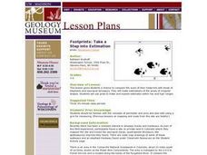
Compare sizes of student footprints with those of elephants and sauropod dinosaurs! Upper graders make estimations of the areas of irregular shapes; students use grids to make and explain estimates within low and high ranges.
Curated OER
Mapping Puerto Rico
Students use maps to discover where Puerto Rico is located. In groups, they use the internet to research the vegetation. They also compare and contrast the relationship between the United States and Puerto Rico's government.
Curated OER
Enough To Make Your Head Spin
Students examine body language in the United States and Bulgaria. They also discover other forms of communication. They also examine a map of Bulgaria.
Discovery Education
Architects in Action
Hands-on and real-world applications are great ways to teach mathematical concepts. Creative thinkers examine how ratios are used to create scale models of buildings and structures. They practice working with ratios by looking at a map...
Curated OER
Tracking Satellites Using Latitude and Longitude
Students, viewing an Internet site, plot the path of several satellites using latitude and longitude over the course of an hour. They learn the four basic types of satellites and their purpose.
Curated OER
Tracing Highs and Lows in San Francisco
On a topographic map, students identify the scale bar, north arrow, and contour interval. They then locate a hill on the map and make note of the contour lines. Students then locate other places with similar contour line patterns....
101 Questions
A Cyclist's Marriage Proposal
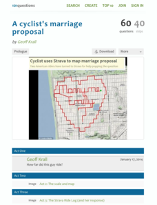
One cyclist goes to great lengths to make his proposal! Your classes must figure out just what length that is. Using a map with a bike route that spells out Marry Me, learners calculate the total distance of the ride. They base their...
Bowland
Alien Invasion
Win the war of the worlds! Scholars solve a variety of problems related to an alien invasion. They determine where spaceships have landed on a coordinate map, devise a plan to avoid the aliens, observe the aliens, and break a code to...
Curated OER
A Map of the Big Race
Students read a novel and practice putting the events into the correct sequence. Using the text, they create a map showing the events of the race in order and a legend. They must use vocabulary from previous chapters and make their map...
Curated OER
Drawing A Map
Students discuss any information they already know about maps. As a class, they draw a map of a park following written directions making sure to include a compass rose and key. They are graded based on a rubric and discuss the need for...
Curated OER
The Crash Scene
Fifth graders explore geography by participating in a mapping activity. In this engineering instructional activity, 5th graders identify the differences between latitude and longitude and practice locating precise points on a globe or...
101 Questions
Neptune
Examine an innovative approach to a large-scale model. Pupils across the state of Maine teamed up to create a model of the solar system that spans 40 miles. Put thinking skills to work within your classes as they make the calculations to...
Curated OER
Metrics And Measurements
Middle schoolers engage in a study of measuring distances between geographical locations on a map. They are able to define and use the map scale in conjunction with the metric system. For this lesson they make their own maps and measure...
Curated OER
Understanding Topographic Maps
Underclassmen create a cone-shaped landform and then draw a contour map for it. Then they examine a quadrangle (which was easily located with an online search), and relate it to what they experienced. The accompanying worksheet is...
Chicago Botanic Garden
Historical Climate Cycles
What better way to make predictions about future weather and climate patterns than with actual climate data from the past? Young climatologists analyze data from 400,000 to 10,000 years ago to determine if climate has changed over...


