Curated OER
Follow the Light
Here is another in the interesting series of lessons that use the special State Quarters as a learning tool. During this instructional activity, pupils learn about lighthouses, maps, the cardinal directions on a compass, and U.S....
Prince William Network
Migration Math Madness
A great way to incorporate math into life science, this lesson plan has learners measure migratory routes on a map and calculate the actual distance that shorebirds on the routes would cover. Learners compute the distance covered in both...
Howard Hughes Medical Institute
Measuring Biodiversity in Gorongosa
Take your biology class' understanding of biodiversity to a whole new level! Ecology scholars use data to calculate three different diversity indices based on the organisms in the Gorongosa National Park. The four-part activity uses an...
Curated OER
Living in the Desert
Conduct an investigation on the plants used by the Hohokam tribe. To survive in the harsh desert environment the Hohokam used many natural resources. Learners read, research, map, and graph multiple aspects of Hohokam plant use as a...
Pennsylvania Department of Transportation
King of Prussia Inn: Exploring Historic Places
Learners of any age examine the significance of historic sites, how we understand those sites, and what they mean in terms of history and the culture of the past. They look at maps, artifacts, and data taken from archaeological sites to...
Curated OER
Geography of Mesopotamia
Students write a letter. For this irrigation lesson, students review how humans and the environment can interact with each other, learn new vocabulary words having to do with Mesopotamia, learn about irrigation and view maps of...
EngageNY
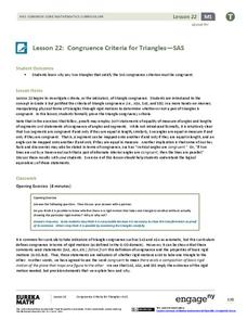
Congruence Criteria for Triangles—SAS
Looking for a different approach to triangle congruence criteria? Employ transformations to determine congruent triangles. Learners list the transformations required to map one triangle to the next. They learn to identify congruence...
Core Knowledge Foundation
The United Kingdom
Scotland, Northern Ireland, Wales, and England are four countries united by more than a monarchy. Academics explore the geography of the nations that make up the United Kingdom. The resource is broken into six lessons focusing on...
Curated OER
The French Revolution and Napoleon, 1789-1815
Here is an interesting and somewhat interactive presentation. Covering the French Revolution, the slide show begins with a timeline of Napoleon's rise to power and ultimate fall. Main ideas for each event are then outlined with critical...
Curated OER
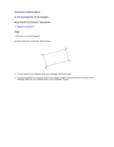
Symmetries of Rectangles
Learners explore mapping a rectangle onto itself using rigid motion concepts, geometric intuition and experimenting with manipulatives in a collaborative task.
Science Matters
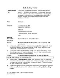
Earth Shaking Events
The world's largest measured earthquake happened in 1960 in Chile, reaching a terrifying 9.5 magnitude on the Richter Scale. The second lesson in the 20-part series introduces earthquakes and fault lines. Scholars map where previous...
CK-12 Foundation
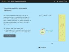
Equations of Circles: The Sea of Happiness
Map this! Help your young mathematicians draw a circular island on a map. Given specifics of the location and size of an island on a map, pupils transform a circle to meet the given requirements. They then determine the location of the...
Curated OER
If the World Were a Village...
Your class members explore concept that the world is a large place, examine how statistics can be used to help in understanding the world and its people, and create illustrations or graphs of statistics found in the award-winning...
Curated OER
Appalachia
Students investigate the benefits of dance and participate in dances. In this dance activity, students investigate a number of dances such as square dancing and clogging that are native to Appalachia. They use math concepts to determine...
Smarter Balanced
Exploring the World
To prepare for the Exploring the World Performance Task, class groups generate a list of places they would like to explore, examine images of seven natural wonders of the world, and consider why these sites are wondrous. A map and images...
Curated OER
Kildare, USA: An Environmental Health Simulation
Your biology class plays the role of epidemiologist when a mysterious illness breaks out in Kildare, USA. Using interviews with doctors, patients, and local citizens, maps, the results from different materials sampling, they work to...
Curated OER
Different Strokes For Different Folktales
Young readers use graphic organizers, such as Venn diagrams and story maps, to analyze a variety of folktales and the elements of a story. They use writing, sequencing activities, and creative art to identify the morals learned from a...
Curated OER
Unit III: Worksheet 1 - Uniform Acceleration
This concise handout posts a diagram of a block sliding down a ramp. High schoolers draw qualitative graphical representations for displacement vs. time, velocity vs. time, and acceleration vs. time. They draw a motion map and list the...
Houghton Mifflin Harcourt
Heroes: Challenge Activities (Theme 5)
Dr. Martin Luther King, Gloria Estefan, Lou Gehrig. A biography, a civil rights quilt, inspiration poetry. This packet of support materials for the Houghton Mifflin Harcourt thematic units on heroes, contains enrichment activities...
Institute of Electrical and Electronics Engineers
Coloring Discrete Structures
What's the least number of colors needed to color a U.S. map? The lesson begins by having pupils view a video clip on continuous and discrete phenomenon, then launches into an activity reminiscent of Zeno's paradox. A separate video...
Geophysical Institute
Latitude and Longitude with Google Earth
Travel the world from the comfort of your classroom with a lesson that features Google Earth. High schoolers follow a series of steps to locate places all over the earth with sets of coordinates. Additionally, they measure the distance...
Teach Engineering
The Great Pacific Garbage Patch
The Great Pacific Garbage Patch is one of several garbage patches around the world where garbage accumulates naturally. As part of a GIS unit that combines oceanography, environmental science, and life science, class members investigate...
Association of Fish and Wildlife Agencies
Schoolyard Biodiversity Investigation Educator Guide
In 1980, in the tropical rainforests of Panama, scientists discovered 1,200 species of beetles living in and around just 19 trees, with most of the species new to science—that's biodiversity! In the activity, learners work in teams to...
Alabama Learning Exchange
Mirror, Mirror on the Wall: Reflections of Light
Why can we see our reflection in a window but not a brick wall? Young physicists learn the Law of Reflection and various light properties that help them answer this and other questions about reflection. Use the PowerPoint to introduce...
Other popular searches
- Cell Transport Concept Map
- Blank Concept Maps
- Genetic Concept Map
- Weather Concept Map
- Krebs Cycle Concept Map
- Science Concept Map
- Phylum Chordata Concept Map
- Concept Map Rubrics
- Inspiration Concept Map
- Dna Structure Concept Map
- Concept Map in Science
- Rock Concept Maps


