Curated OER
Mapping the Past
Students study historical maps to view how the world evolved from medieval times through the Renaissance. They work in groups to examine the maps and present a report on one of the listed maps.
Curated OER
Mapmaker, Mapmaker, Make Me a Map!
Students evaluate the different types of historical and geographical information that one can gather through close study of historical maps from the 16th through the 19th centuries. They create their own maps.
Curated OER
What Do Maps Show?: Lesson 1 Introduction to Maps
Learners brainstorm a list of the different types of maps they have seen or used. Using the activity sheet, they look through a social studies book to find all the maps and to determine what they are used for. Using a poster, they review...
Curated OER
Mapping the Halifax Explosion
Students research the Halifax Explosion using historical maps.
Ashbrook Center at Ashland University
The Constitutional Convention
Imagine sitting down with representatives of your school to write a new student handbook. What arguments would ensue? How would compromises be made to finish the project? Scholars research the Constitutional Convention using a directory...
Curated OER
Mapping Perceptions
Students create and read maps. In this map skills lesson, students draw a map of their neighborhood, then use skills acquired during map-making to interpret a classmates map and a map of the Ming Dynasty.
Curated OER
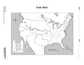
Trails West: Westward Expansion Maps
In this United States historical map learning exercise, students examine the trails that settlers of the Western United States took during the period of Western Expansion. Major cities on the routes are labeled.
Curated OER
Colonial America 1776 Map
In this United States historical map worksheet, learners examine the colonial boundaries in 1776 as well as the Proclamation Line of 1763.
Curated OER
The 13 British Colonies Map
In this United States historical map worksheet, students examine the 13 colonial boundaries and noted major cities.
Curated OER
Trails West Map
In this United States historical map worksheet, students examine the trails that settlers of the Western United States took during the period of Western Expansion.
Curated OER
Holocaust Map Studies
Students analyze maps and answer discussion questions related to WWI. In this geography lesson, students analyze historic maps to determine causes and effects of WWI in Europe. Students read testimonies of Holocaust survivors and label...
Big History Project
Human Migration Patterns II
While humans have always been on the move, the period between 1400 and 1800 saw vast migrations of people between the East and the West. These migrations—whether through slavery or a desire to colonize new lands—shaped the modern world....
Curated OER
Mapping National and Geographic Identity
Students analyze geographic maps. In this map analysis lesson, students analyze the symbols in geographic maps and the impact of cultural, historical, and political concepts. Students compare and contrast maps in various mediums by...
Curated OER
Play Doh Map of Your State
Students create a state map using Playdoh. In this hands-on state geography lesson, students work in groups to form a three-dimensional map of their state using Playdoh made at home following a (given) recipe. Students use four colors...
Curated OER
The Map Cartouche
Students discuss the history and purpose of cartouches. They examine examples of cartouches and design an original example with symbols of their choosing.
Curated OER
Waldseemuller's Map: World 1507
Students investigate the 1507 word map. In this world geography lesson, students examine the details of each section of the map and then draw conclusions about how the people of 1507 understood the world. Students are evalated on...
Curated OER
George Washington's Revolutionary Journeys
Students take a closer look at historical maps. In this American Revolution activity, students examine the provided historical maps and documents to determine the assignments that George Washington assigned to subordinates during the...
Curated OER
Assessing and Making Maps
Students evaluate maps using the TODALSIGs basic map analysis system, explained on the worksheet. They create a map of Alaska using TODALSIGs. Students brainstorm the elements of maps.
National Endowment for the Humanities
Lesson 3: On the Road with Marco Polo: From Hormuz to Kashgar
Young explorers examine the route that Marco Polo and his father traveled to reach China. They examine online maps of the Silk Road and harsh terrain of Afghanistan to determine challenges that may have been encountered during travel.
Education World
The African American Population in US History
How has the African American population changed over the years? Learners use charts, statistical data, and maps to see how populations in African American communities have changed since the 1860s. Activity modifications are included to...
Curated OER
Understanding "The Stans"
Students explore and locate "The Stans" in Central Asia to create, write and illustrate maps, graphs and charts to organize geographic information. They analyze the historical and physical characteristics of Central Asia via graphic...
Curated OER
United States of America: 1860
In this United States historical map worksheet, students examine the boundaries of the states and territories of the nation in 1860. This map is unlabeled.
Curated OER
United States of America: 1860
In this United States historical map worksheet, students examine the boundaries of the labeled states and territories of the nation in 1860.
Curated OER
Denali Park Topographic Maps
Young scholars construct a topographic map of the Denali National Park. They identify different elevations and record historic landmarks in student science journals.


