Curated OER
Geography 12
Geography is such a fascinating subject for learners of all ages. Prepare learners with good guiding questions, which they can use while reading their texts. Each of the provided 13 questions requires a full paragraph response on the...
Curated OER
Sub-Saharan Africa: Physical Geography
In this geography skills worksheet, learners respond to 22 short answer and map skills questions about the location and geographic features of sub-Saharan Africa.
Delegation of the European Union to the United States
The Geography of Europe
What is the European Union? Where is it? Why is it? To begin a study of the EU, class members examine the physical geography of Europe and the size and population density of 28-member countries in comparison to non-member countries like...
Curated OER
Geography: Physical Features
Physical features in our geography are outlined in this colorful PowerPoint. First, different physical features are listed. Then, they are defined with a corresponding graphic. Tip: While presenting this slideshow to your class, ask them...
Curated OER
Physical Geography of Africa
Fifth graders investigate the topography of Africa. In this physical geography lesson, 5th graders research the six regions of Africa and complete a physical map. Students locate various landforms in Africa. Students use their...
Curated OER
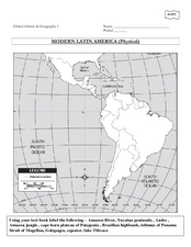
Global History & Geography: Latin America
The instructions say to use a text-book to label 11 different regions in modern Latin America. If a text-book is not available a map can be found on-line and printed for student reference.
California Polytechnic State University
Australian Geography Unit
At the heart of this resource is a beautifully detailed PowerPoint presentation (provided in PDF form) on the overall physical geography of Australia, basic facts about the country, Aboriginal history, and Australia culture and lifestyle.
Curated OER
Maps
If your students are just starting a unit on Geography this could be the introduction you're looking for. This PowerPoint presents a clear and organized overview of the different types of maps people use and why each is important. Tip:...
Curated OER
Geography: Puerto Rico
Take a trip to Puerto Rico! Learners engage in a web quest, identify Puerto Rico on the map, and gather information related to physical features and cultural factors. Their efforts culminate when they design a brochure comparing the...
Curated OER
Basic U.S. Geography
Provide your 11th graders with a basic understanding of U.S. Geography. They label the state, regions, and boundaries found in the contiguous U.S. as well as Hawaii and Alaska. Then, they complete two Internet related activities.
Curated OER
Physical and Human Geography Review Worksheet and Study Guide
In this geography skills worksheet, students respond to 30 short answer questions pertaining to physical and human geography.
Curated OER
World Map and Globe - Lesson 15 Mountains of the World
Students locate major world mountain ranges. In this geography activity, students identify major mountain ranges on 6 on of the 7 continents on a large world physical map.
Curated OER
World Map Labels
In this geography skills worksheet, students identify the countries and bodies of water labelled on the maps of the world, Africa, Asia, Canada, Europe, the Caribbean, the Middle East, North America, Australia, and South America.
Curated OER
Physical World Map
In this world map worksheet, students practice their geography skills as they label the 7 continents and 5 oceans. Teachers may use this physical map for various classroom activities
Curated OER
World: Physical Map
In this world physical map worksheet, learners make note of the major landforms located on this Robinson projection map.
Curated OER
Australia and Oceania: Physical Map
In this Australia and Oceania physical map worksheet, learners make note of the major landforms and bodies of water located within this region.
Curated OER
Africa & Asia: Physical Map
In this African and Asian physical map worksheet, students investigate the major landforms and bodies of water located on the African and Asian continents.
Curated OER
Central America Region: Physical Map
In this Central America physical map instructional activity, students make note of the major landforms located in this region of the world.
Curated OER
Eurasia Physical Map
In this Eurasia physical map worksheet, learners make note of the major landforms and bodies of water located in this world region.
Curated OER
South America: Physical Map
In this South American physical map worksheet, students make note of the major landforms and bodies of water located on the continent.
Curated OER
Europe Physical Map
In this Europe physical map worksheet, students make note of the major landforms and bodies of water located on the continent.
Curated OER
Asia Physical Map
In this Asia physical map activity, learners make note of the major landforms and bodies of water located on the continent.
Curated OER
USA: Physical Map
In this United States physical map worksheet, students investigate the major landforms and bodies of water located throughout the country.
Curated OER
Americas: Physical Map
In this Americas physical map activity, students make note of the major landforms and bodies of water located on the North American and South American continents.
Other popular searches
- Europe Physical Geography
- Canada Physical Geography
- Physical Geography of Africa
- Physical Geography of Europe
- Human and Physical Geography
- Physical Geography of Japan
- Physical Maps of Europe
- American Physical Geography
- Africa Physical Geography
- Earth's Physical Geography
- African Physical Geography
- Physical Geography of Canada


