Curated OER
Playground Mapping
Students convert their physical models of a playground from a previous lesson into a map of the playground that includes a scale and key. They examine and discuss examples of maps, view an image to map photo essay, and create a map using...
DiscoverE
LIDAR: Mapping with Lasers
We would be lost without maps! How are they made? Introduce junior topographers to LIDAR technology with a fascinating activity. Set up a mock city, then have learners operate a laser measure to determine the shape of the landscape using...
Curated OER
Orienteering - Lesson 4 - Distance and Height
Pretend that you've been dropped onto a mountain, in the middle of nowhere, and all you have to find your way is a topographical map and a compass. Could you find your way to the nearest town? Orienteering teaches the skills of map...
Laboratory for Atmospheric and Space Physics
Planetary Distances on the Playground
There's no need to stay inside; get out of the classroom and create a scaled map of the solar system on your playground field! In collaborative groups, scholars identify the distance between the sun and other planets, place planet...
Curated OER
A Real Life Example of the Distance Formula
Students answer the following question: "Using the lines of latitude and longitude, what is the distance (in degrees) if you were to travel from NASA Dryden to NASA Ames?" They use the distance formula to find the distance (measured in...
Institute for Geophysics
Understanding Maps of Earth
Here is your go-to student resource on primary geography concepts, including facts about the surface of the earth and its hemispheres, latitude and longitude, globes, types of maps, and identifying continents and oceans.
Curated OER
You Are Here
Students map local places and learn to use scale and distance. In this mapping lesson, students map their school and a favorite place. Students recreate their maps showing distance and scale sizes. Students locate their location on a...
Curated OER
Estimate Distances on a Map
In this estimation worksheet, students estimate the distance on a city map based on the scale given to them. Students answer 4 short answer questions.
Curated OER
Scale Skills
In this mapping skills worksheet, students read an excerpt that describes three different types of scales and how to calculate distance on a map. They respond to two short answer questions using the map provided on the sheet and to...
Curated OER
The Sustainable Olympics
In this sustainable Olympics worksheet, students utilize a large map of the British Isles, map scale a long piece of string to calculate the approximate distance between their school and 8 locations where some of the Olympic events may...
Curated OER
Contour Map Worksheet #2
Following a contour map of a hill, a stream, and the ocean, are five multiple choice questions. Earth science enthusiasts determine elevation, direction of water flow, distance, and steepness. They also match the map to a selection of...
Curated OER
Estimating Distances
Fifth graders explore the concept of estimating distances between two places on a map. In this estimating distances lesson, 5th graders interpret maps according to measuring distance. Students choose a place on a map and find the...
Curated OER
Planning A Railroad
Students use topographical maps students explain the challenges involved in building the railroad in the Sierra Nevada mountains.
Curated OER
Principles of Flight: Where are We?
Students explore the concept of topographical maps. In this topographical map lesson, students discuss how airplanes know where to fly. Students use topographical maps to simulate a field trip on the computer.
Curated OER
Maps, Charts, and Graphs
Students define key geographic terms and track a hurricane on a map. They examine various types of maps and find locations on them,including rivers, cities and mountains.
Curated OER
Map Studies - Estimate And Measure Distance
First graders explore estimating and measuring distances. They analyze and discuss a map of New York State, make estimations, measure distances using yarn, and calculate total distances between cities on the map.
Alabama Learning Exchange (ALEX)
Sonar Mapping of the Ocean Floor
Eighth graders participate in an experiment that emulates a sonar signal bouncing off the ocean floor. They determine how the ocean floor is measured by the length of time it takes for the sonar signal to return. They work with a wooden...
Bowland
Alien Invasion
Win the war of the worlds! Scholars solve a variety of problems related to an alien invasion. They determine where spaceships have landed on a coordinate map, devise a plan to avoid the aliens, observe the aliens, and break a code to...
Curated OER
Contour Map Worksheet #1
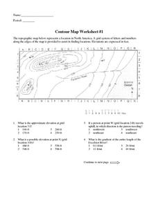
Being able to read a topographic map is a standard in middle school earth science units and imperative for outdoor enthusiasts. As you introduce learners to this skill, you can assign this as an assessment or reinforcement. Pupils view a...
Curated OER
Mapping It Out: A Post-Trip Lesson
Students make a rough map of Yosemite and add elevations to the map. They are encouraged to bring photos from the trip and add them to their map.
Curated OER
Data Comparison And Interpretation: North Korea, South Korea, And the United States
Ninth graders brainstorm "what they know about North Korea and South Korea." They determine the approximate distance from the United States to North and South Korea and create a graph comparing the birth rates, death rates, infant...
Curated OER
Globe Skills Lesson 7 The Transcontinental Railroad
Students explore the Transcontinental Railroad. In this geography skills lesson, students use map skills in order to locate legs of the Transcontinental Railroad on globes.
Curated OER
Globe Skills Lesson 8 Dust Bowl Travelers
Students develop their globe and map skills, In this geography lesson, students examine the Dust Bowl as they complete an activity that requires them to plot latitude and longitude.
Curated OER
Travel Time
Students use a migration map to estimate the distance traveled by a bird while migrating south. After calculating accurate estimates of the distance traveled, students compare the distances traveled with the amount of time elapsed.


