Curated OER
Ocean Currents
Fourth graders work in groups to research ocean currents and create posters with their findings. They locate the patterns and names of major ocean currents and identify them on a map. Students also use red pencil to show ocean currents...
Curated OER
1492: Using Data to Explain a Journey
Young scholars examine how Christopher Columbus made his way across the Atlantic. In this data instructional activity students use an Internet program to navigate like Columbus.
Curated OER
Exploring a Map of Canada
In this exploring a map of Canada worksheet, students find and label the capital city, bodies of water, the U.S., the provinces and the territories of Canada.
Curated OER
Africa: Political Map
Students create a political map for Africa. For this country identification lesson, students locate Africa on a globe and discuss some of its major countries and bodies of water. Students complete a political map of Africa and test...
Curated OER
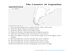
Map of Argentina
In this map of Argentina worksheet, students label key areas, cities, bodies of water and surrounding countries, then color the map according to directions.
Curated OER
Using a Political Map
In this online interactive map activity worksheet, learners examine a political map of New Jersey and respond to 9 fill in the blank questions.
Curated OER
Mapping the Civil War
Students identify the locations of pivotal American Civil War battles. In this map skills activity, students label Fort Sumter, Antietam, Vicksburg, Gettysburg, and the Battle for Atlanta on an outline map. The map is not included.
Curated OER
River Run Through It
With vocabulary lists, worksheets, and more, this lesson sets learners on an exploration of the Hudson River area. They read an essay about the area, analyze a relief map of New York State, and complete a worksheet.
Curated OER
Exploring the Map of Morocco
In this exploring the map of Morocco worksheet, students find and label cities, islands, bodies of water, mountains, deserts and other countries around Morocco.
Curated OER
Rivers Run Through It
Using a relief map of New York State, learners answer questions about the distance between different cities, identify bodies of water, and more. First, they discuss vocabulary related to the Hudson River area. Then, they complete a...
Port Jefferson School District
Hurricane Katrina
Young scientists track Hurricane Katrina across the Atlantic Ocean as they learn about these destructive forces of nature. Provided with a table of data tracking the location and conditions of Katrina over a one week span, students plot...
Curated OER
Currents and Climate
In this ocean currents worksheet, students will compare two different currents found in the Atlantic Ocean to determine how currents affect the climate in these regions. This worksheet has 3 short answer questions.
Curated OER
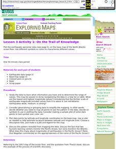
Lesson 3 Activity 1: On the Trail of Knowledge
High schoolers plot the earthquake epicenter data on the base map of the North Atlantic ocean floor using different symbols or colors to characterize different values.
Curated OER
Round and Round
Learners interpret data from a three-dimensional array of current monitors to determine an overall pattern of water circulation. They hypothesize what effect an observed water circulation pattern might have on seamount fauna. A very...
Curated OER
Ocean Currents
In this ocean currents learning exercise, students will use maps of the Atlantic Ocean currents and the Pacific Ocean currents to complete 6 short answer questions.
Curated OER
COLONIAL FLYERS/TRAVEL BROCHURES TO THE COLONIES
Students investigate concepts of history and geography in this lesson plan. They create travel brochures for travelers who are crossing the Atlantic Ocean to populate the colonies of early America. The brochure has topographical...
World Maps Online
Introduction to the World Map
Students identify the differences between maps and globes. In this map skills instructional activity, students are shown a globe and a map and recognize the differences. Students use post-it notes to locate several locations on the world...
Curated OER
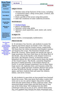
Ocean Planet: Sea Secrets
Students identify ocean features and draw a profile using data points on a map. Through discussion and research, they discover the importance of oceanography and plot a profile of the ocean floor in search for a vessel full of precious...
Curated OER
Is the Hudson River Too Salty to Drink?
Students explore reasons for varied salinity in bodies of water. In this geographical inquiry lesson, students use a variety of visual and written information including maps, data tables, and graphs, to form a hypothesis as to why the...
Curated OER
Bermuda Triangle: Map Activity
In this Bermuda triangle worksheet, students complete a set of 4 questions using a given map of the Bermuda triangle. Answers are included on page 2.
Curated OER
Creating a Map of France
In this crating a map of France worksheet, students find and label important parts of France, bodies of water, mountains and surrounding countries.
Curated OER
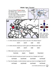
Middle Ages Traveler
In these Middle Ages worksheets, students use the maps to help them find the answers to the questions that help them understand the directions of north, south, east and west. Students also color another map of France according the...
Curriculum Corner
Earth Day Book
This Earth Day, celebrate our beautiful planet with an activity book that challenges scholars to show off their map skills, complete a crossword puzzle, write acrostic poems, alphabetize, and reflect on their personal Earth-friendly habits.
Curated OER
Christopher Columbus
This is a nicely done presentation on the voyages of Christopher Columbus. Most young historians don't realize that Columbus made, not one, but four journeys from Spain across the Atlantic Ocean to the New World. This PowerPoint does a...


