Curated OER
Problem-Solving Decisions: Reasonable Answers
For this problem solving worksheet, students answer 6 questions pertaining to a story problem about a tabletop scale model of the Nile River.
Curated OER
Cattle Trails
Students identify and locate cattle trails on a globe. In this map skill lesson, students use a marker to locate Texas and Montana and use the map scale to calculate the distance of the cattle trail.
Curated OER
Globe Skills Lesson 6 The Louisiana Purchase
Students explore the Louisiana Purchase territory. In this geography skills lesson, students use map skills in order to plot and note latitude and longitude, measure scale distance, and locate landforms that were part of the Louisiana...
Curated OER
Globe Skills Lesson 7 The Transcontinental Railroad
Students explore the Transcontinental Railroad. In this geography skills lesson, students use map skills in order to locate legs of the Transcontinental Railroad on globes.
Curated OER
Globe Skills Lesson 8 Dust Bowl Travelers
Students develop their globe and map skills, In this geography lesson, students examine the Dust Bowl as they complete an activity that requires them to plot latitude and longitude.
Curated OER
Earth on the Earth
Fourth graders plot points on a graph and transfer those coordinates onto a large scale model resulting in an outline of the Western Hemisphere. They identify the major geographical landforms of the Western Hemisphere.
Curated OER
Globe Skills Lesson 10 Apollo 11
Students develop their globe skills. In this geography skills instructional activity, students use a globe and a softball to replicate distance between the earth and its moon.
Curated OER
Battle of Clontarf 2
In this Battle of Clontarf worksheet, students read about the battle, answer short answer questions, draw a picture, and estimate the population. Students complete 4 activities.
Curated OER
Globe Skills Lesson 5
In this map skills activity, students read a text selection about locations during the American Revolution and then respond to 8 fill in the blank questions.
Curated OER
Give Me Back My School: A Back to Basics Approach to Ecological Restoration
Ninth graders research local geography to create successful, ecological school landscaping. They determine soil type, average weather patterns and temperature graphs and use the information to select ideal plants and plant maintenance...
Curated OER
Metrics And Measurements
Students engage in a study of measuring distances between geographical locations on a map. They are able to define and use the map scale in conjunction with the metric system. For this activity they make their own maps and measure the...
Curated OER
Mush! Tracking Travelers on the Trail
Students get to know Alaska and the Iditarod route that is run by dogs as they track the mushers' progress on a map that they create specifically for the race. They learn about latitude, longitude, plotting on a map, checkpoints, and...
PBS
Home, Sweet, Home!
Students investigate the local history and architecture of their community. They draw maps, conduct Internet research, discuss varied architectural designs, take a walking tour of their town and work in teams to record their community's...
Curated OER
Mapping a Stream
Students map an actual local waterway. They create full color scale drawings that include windfalls, plant cover, streambed composition, and landmarks such as trees, boulders, and slumps. This is a long-term project that involves...
Curated OER
Mud Maps
Learners discuss the location of stores, buildings, and homes in their community. Afterwards, they create a 'mud map' demonstrating the route from one point to another. In pairs, students read travel directions from a brochure, while...
Curated OER
Media Center Map Skills
Student demonstrates the ability to locate, retrieve, and handle media and equipment by utilizing the library media center floor plan, symbols, and guides. They then use systems of classification to identify, locate, and retrieve materials.
Curated OER
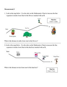
Measurement 3: Rulers
In this measurement worksheet, students measure the linear distance, in inches, between stated objects. Next, they determine the actual distance, in miles.
Curated OER
Mapping Potato Island
Learners create their own topographical map using a potato. In this hands on instructional activity students construct a topographical map and explain what contour lines are using a potato.
Curated OER
Mapping Your Community
Students define the boundaries of their community by comparing the community's official boundaries with other historical, political, physical, and perceived boundaries of the area and create a community map.
Curated OER
Mapping with a Compass: A Simulated Survey
Students use compasses and grids to map the locations of artifacts found in a simulated dig site. In groups, they role-play as future archeologists excavating a school site. Groups begin at their assigned datum and site the artifacts...
Curated OER
May We Present Planet Earth?
Learners draw a map to scale. They illustrate knowledge of how to use DOGS TAILS on a map. Students identify the main parts of a map. They identify and illustrate the major features necessary for sustaining a quality of life for a society.
Curated OER
FINDING A RESOLUTION
Students examine detailed Moon and Earth views provided by the NASA-sponsored "World Wind" computer program. They work in groups to create maps of different scales using landmarks of their choice, and challenge their classmates to...
Curated OER
Schoolyard Geology
Discover that maps show information about an area and that they have common features like scales and legends. View an aerial map of your school and find features on the map such as the playground, roads, and trees. Trace the outline of...
Curated OER
Candy Bar Subsurface Geology
Students are introduced to drawing and interpreting topographical maps. They each cut through there Jell-o mountain at regular height intervals, and trace around the shape of the Jell-o cut off at the height, overlaying the different...


