Curated OER
The borders of Europe. Geographically location or cultural artifice?
Twelfth graders discuss where they regard the boundaries of Europe to be. They raise their awareness that "Europe" may be more of a cultural construct than geographical defined continent.
Curated OER
The Geography of Europe
Learners examine maps of Europe. In this geography skills instructional activity, students interpret several maps to determine the boundaries of the European Union and respond to assessment questions about the maps.
Curated OER
Europe at Exploration 1500
In this world empires and trade in 1500 worksheet, students examine a world empire map, world trade map, and Europe map. All maps display information from 1500.
Curated OER
The Interconnectedness of Ancient Peoples Map Study
Seventh graders begin this lesson by viewing various maps of the Ancient World. As a class, they take notes on the changes of different areas in Europe and Asia as their teacher lectures to them. They answer questions about the...
Curated OER
Map Skills: Explorers, Continents, and Oceans
Third graders use a software program to make and label a map of the world. On the map, they locate the seven continents, oceans and the countries of Europe. They also draw the routes of Christopher Columbus, Juan Ponce de Leon and...
Curated OER
Exploring the World's Geography
Students discuss the seven continents of Earth and the diverse geography. After discussion, they create their own paper-mache globes which properly display all seven continents, the equator, and the prime meridian. They conduct research...
Curated OER
World War II Geography
Students explore the geography of Europe. In this World War II lesson, students study and represent countries involved in the war as they participate in a simulation that requires them to discuss war events and how their countries were...
Curated OER
Number the Stars Geography
In this geography and literature worksheet, students explore the location of the 3 countries mentioned repeatedly in Lois Lowry's novel Number the Stars. Students color the countries on a map of Europe and create a key to match the...
Curated OER
Mapping Population Changes In The United States
Students create a choropleth map to illustrate the population growth rate of the United States. They explore how to construct a choropleth map, and discuss the impact of population changes for the future.
Curated OER
Where Is Rome?
Third graders discover Ancient Rome through maps and worksheets. In this world history activity, 3rd graders locate Rome on a world map and identify the scope of the Roman Empire. Students label an entire map of Italy after...
Curated OER
Exploring an Atlas
Students explore global geography by participating in an atlas activity. For this countries of the world lesson, students collaborate in small groups and analyze an atlas while researching continents, countries and demographics. Students...
Curated OER
China - the Geography of European Imperialism - Spheres of Influence in China
Ninth graders create a map of China. They identify the various spheres of influence carved out by the Imperialist powers of Europe as well as locating geographical features of china and major cities. They explain the global impact of...
Curated OER
Look! You're Wearing Geography
Sixth graders explore economic systems. In this economics lesson, 6th graders discover global markets. Students work in small groups to identify where their clothing and materials originated. Students locate countries on a map and...
Curated OER
Political Geography of Europe
Fifth graders listen to a lecture that traces the political geography of Europe from 814 through 1997. They incorporate these themes into a research project on Western Europe.
Curated OER
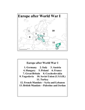
Europe after World War I
In this Europe after World War I map worksheet, learners note the 11 regions of the Europe labeled on the map.
Curated OER
People Power
Students view a television program that explores many Eastern European residents' discontentment with communism. They work in groups to research living conditions in an Eastern European country before communism, under communism and...
Curated OER
Roman Empire: Physical Framework - Location, Borders, Dimensions
Students relate the classical world to the modern world. In this map skills lesson plan, students turn a blank map into a colorful complete map by following step-by-step directions. This lesson plan allows students to connect our current...
Curated OER
European Agriculture
Students make inferences on how physical geography affected the development of early civilizations and come up with solutions to global issues. In this physical geography lesson plan, students compare maps of the past to maps of today to...
Curated OER
The European Union
Students complete an in-depth exploration of the European Union using the five themes of geography as a guide. In small groups, students use traditional and technological resources to answer questions about the European Union, with each...
Curated OER
Number the Stars
Students read Number the Stars. In this social studies lesson plan, students read the story and use a map of western Europe and identify the countries involved in the war. Students locate the cities of Denmark that are discussed in the...
Curated OER
Introduction to the World Globe
Learners examine a globe and the world map to see what constitutes the differences. In this world map introductory lesson plan, students discuss what they see when they view the globe. Learners then, look at a world map and compare the...
Curated OER
Continents
Students investigate World Geography by researching the different continents. In this Asian Geography lesson, students discuss the continent of Pangaea and color a worksheet of the continents. Students locate China on the map worksheet...
Curated OER
Globe Skills Lesson 2: Paving the Way for Columbus
Pupils explore the expedition of Christopher Columbus. In this geography skills lesson, students consider the technological advances that made Columbus's expedition possible as they complete a latitude and longitude activity.
Curated OER
Globe Skills Lesson 4 The Colonial Period
Learners practice their map skills. In this Colonial geography instructional activity, students complete an activity that requires them to locate English colonial locations using latitude and longitude coordinates.


