Curated OER
Tour Of South America
Students explore South America. In this geography instructional activity, students research landmarks of historical or national significance and use their findings to create slideshows.
Curated OER
British Isles
In this map worksheet of Britain, students study a detailed outline map of the British Isles. No labels are provided and there are no directions.
Curated OER
Australia
In this map of Australia worksheet, students research and study a map of Australia. Students label Australia's regions, major states and important landmarks.
Curated OER
Freeform Rhode Island Map
In this free form Rhode Island map worksheet, students study, locate and memorize key cities, physical attributes and surrounding states for a quiz. Students fill out the major cities on a blank map of Rhode Island.
Curated OER
An Introduction to the Night Sky and Movement Astronomy
Basically, this is an interactive exploration of educational astronomy software and an app. Young astronomers discover how the apparent motion of the sky relates to Earth's movements and the position of the observer. It is out of this...
Curated OER
Sense Poems
Young scholars explore 5 senses poetry. In this poetry writing instructional activity, students visualize a special day and brainstorm related vivid adjectives and phrases. Young scholars create mindmaps of the five senses to...
Curated OER
Arkansas State Mineral: Quartz Mineral
The quartz crystals found in the mountains of Arkansas are among the purest and clearest in the world! This lesson has middle schoolers focus on this state mineral of Arkansas as they study the state's geography. A fun game is...
Curated OER
Foliage Tracker
Young scholars discuss the change of leaf colors and the role that climate and elevation play in those changes. They then track leaf changes, input data, and graph foliage changes with a free online tool.
Curated OER
So & So That
When do you use "so" or "so that"? Practice this skill with your ESL students in this worksheet, which includes twenty multiple-choice questions. Each question prompts English learners to choose the correct way to complete the...
Curated OER
U.S. Geography: The South
Young geographers complete a research project. They list the physical features found in the American South. They then discuss the economy, culture, and geography found in the South. They work in groups to research one of the five...
Scholastic
Biographical History
Elementary learners study and research an important historical figure. They research a historical figure and use a four square organizer to take notes. They develop a timeline and poem that reflects the life of the historical figure....
PBS
Exploring Parent-Child Relationships Through Letter Writing
The PBS film, Bronx Princess, launches a study of complex parent-child relationships. Using the provided reading guide, viewers respond to clips from the film and compare Rocky and Yaa’s relationship to other parent-child relationships....
National Geographic
Altitude: What's in the Air?
Introuduce your scientists to the differences in air at varying altitudes with a colorful explanatory graph. After some discussion, they view unbelievable footage of mountain-climbing Leo Houlding and a narrative about how he might do...
Agriculture in the Classroom
Build it Better
If you think you can do better, feel free to give it a try. Pupils learn about the work on Temple Grandin and consider ways to improve animal handling facilities. They work in groups to build models to showcase their ideas.
Baylor College
Microbes and Disease
Discuss how diseases have impacted human history. Divide your class into groups and assign each group one of the following: tuberculosis, malaria, plague, cholera, smallpox, and AIDS. They read up on, complete a concept map, and present...
Curated OER
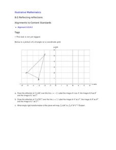
Reflecting Reflections
A triangle rests in quadrant two, from which your class members must draw reflections, both over x=2 and x=-2. This focused exercise strengthens learners' skills when it comes to reflection on the coordinate plane.
Curated OER
Tracing Our Own Family Pilgrimages
Pupils observe a world map and are introduced to vocabulary like: cities, continents, rivers, lakes, and oceans. They discuss the names of the cities they live in and locate them on the map; then using a colored pushpin indicate: the...
Curated OER
How is our place connected to other places?
Second graders conduct a survey, they record their data with the help of maps. They use an aerial photo or Ordnance Survey map, 2nd graders pinpoint specific places and add them to a legend using the drawing tools. Students use...
Curated OER
Where In the World Are You?
Fourth graders fill in blank copies of the United States Map and then the World Map.
Curated OER
Geotagging in school
Students create a digital photo map of the world. In this digital photo map lesson plan, students pick topics such as the Olympics, natural disasters, or trip planning and create a photo map on the computer.
Curated OER
How to Teach Geography with KidPix II
Learners use the computer program KidPix II to color a map of the world. In this world map lesson plan, students fill in different colors for different continents that are told to them on the program KidPix II.
Curated OER
Polar Day: Comparing My Community to a Northern Community
Third graders practice their geography skills. In this Polar Day-themed lesson, 3rd graders use their research skills to compare and contrast the place, regions, and human systems in their community to a Canadian northern polar region...
Curated OER
Geology and the Battle of Gettysburg
Students create geologic maps of the Gettysburg battlefield. In this geologic skills lesson, students consider the variations of Earth's surfaces and explore strategies employed by the North and South in the Battle of Gettysburg to...
Curated OER
Life Long Learning
Twelfth graders complete a research activity to learn about post-secondary education and possible career paths. In this college and career search lesson, 12th graders locate colleges of interest on a map and explore information in a...


