Curated OER
Central America Outline Map - Labelled
In this Central American political map instructional activity, learners make note of national boundaries and capitals in this region of the world. National capital city locations are noted with stars.
Curated OER
Pandemic Flu
Students review the difference between viruses and bacteria, and provide examples of illnesses that each can cause. To help students comprehend how quickly an influenza infection can spread, they perform an activity. They are placed in...
Curated OER
Letters from Rifka
Fourth graders read Letters from Rifka and discuss the feelings of people forced to leave their homes and countries. For this migration lesson, 4th graders relate their feelings about moving from their home forever. Students trace...
Curated OER
4: In With the Imports
Students research imports of American Samoa and Hawaii and create a map showing the major imports for both. In this economics lesson, students identify where American Samoa and Hawaii are on a map, discover what the imports for the...
Curated OER
Country Project
Students research any part of the United States that they want to know more about. This may include the culture, food or people. They have to present their information to the class, display a visual aid and write a paper on the...
Curated OER
Helping Countries in Turmoil
Students discover the struggles of emerging democracies. In this service learning lesson, students research a non-profit agency that is assisting the people of an emerging democracy and create and advertisement.
Curated OER
Graphic Organizing: Early American History
In collaborative groups, young US historians sort cards (each labeled with a single early American event or issue) according to which of the first four presidents was leading the country at the time. Learners copy the events onto a...
Curated OER
Los Estados de Mexico
Students investigate the country of Mexico and its geographical regions. They conduct research using a variety of resources. The information is used in order to create the context for creating a clay model labeled with the geographical...
Curated OER
The Crimean War
Use the list of cities, countries, and water ways to correctly label a map of the regions associated with the Crimean War. There are approximately 20 locations to locate and identify.
Constitutional Rights Foundation
Refugees From Vietnam and Cambodia
The United States may have pulled its troops from the Vietnam War in 1973, but the conflict was far from over for the citizens living in Asia at the time. An informative resource lets learners know about the wave of over 220,000...
Curated OER
ESOL Consumer Education
Students discuss the importance of reading and understanding price
tags, labels and expiration dates. They Compare/contrast the significance and practice of reading food labels, expiration dates and prices of food items in students'...
Curated OER
Riding With Alice
Student listen to Don Brown's, Alice's Grand Adventure before discussing cross country travel. They trace Alice's travels on an outline map of the US and focus on the state of Indiana. They color and label the counties that Alice...
Curated OER
Hispanic, Latino - What's the Right Word? an Examination of the Language Used To Categorize People
Students define "Hispanic" and "Latino," analyze where these terms come from, and develop an awareness of racial labels.
Curated OER
2 Cities: Europe's Capital Cities
In this European cities worksheet, students label the countries and then provide an alphabetical key for each country. Students then label each capital city and provide a numerical key for each city.
Curated OER
Globe Raider: Part III
Students research a Spanish speaking country before developing a PowerPoint slideshow to share with the class. They come to the computer lab with research work complete so that they can work with their group to create the slides.
Curated OER
Mapping Spain
In this map labeling worksheet, students follow directions to label 10 items on a map of Spain. They label the capital city of Madrid, the Pyrenees Mountains, surrounding water bodies and countries. They trace the flow of the Duero River.
Curated OER
Gross Domestic Pizza
Middle schoolers explore major components of gross domestic product (GDP) and how it is determined; students create and compare GDP pie charts for the countries of Pepperonia and Anchovia.
Curated OER
Where in the World Is ...?
Students move themselves around a "world" map on the classroom floor, using lines of latitude and longitude to locate specific spots. They determine the locations of 11 countries where Peace Corps Volunteers are serving and identify in...
Curated OER
Clothesline Sleuth
Third graders discover the origin of an item of clothing. In this clothing lesson, 3rd graders navigate the net to locate information related to various fabrics. Students answer questions and define vocabulary about...
Curated OER
Families Around the World
Students discover the similarities and differences in families from around the world. In this multicultural lesson, students create their own family album and label each family member. There are suggested activities such as investigating...
Curated OER
A Map of Ghana
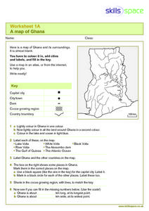
In this Map of Ghana worksheet, students are given a blank map and key. They are told to label major features and color according to directions.
Curated OER
What a Relief Map
Students create a map using cookie dough. In this geography lesson, students research the physical features of a country, draw a diagram and design and create a map out of cookie dough.
Curated OER
Social Studies:
Learners identify various types of breads fromother countries and locate them on maps. In small groups, they make story maps of books that mention bread and make books resembling sandwiches. Students have a bread tasting party and...
Curated OER
Identifying and locating the continents and oceans of the world.
Third graders physically construct a balloon replica of the world globe by coloring, correctly labeling, and cutting out the seven continent shapes from the worksheet, gluing them onto their correct locations on an inflated blue balloon....


