Curated OER
I Am A Rock, I Am An Island: Describing Landforms and Bodies of Water
Students identify common landforms and bodies of water from descriptions of distinguishing features. For this landforms and bodies of water lesson plan, students describe the features they see in the pictures given to them.
Curated OER
Understanding the Water Cycle
Investigate the water cycle and how water moves from the land to the air and back to the land. Create a terrarium and observe the water cycle at work. Define weather terms including evaporation, condensation, and precipitation.
Curated OER
Salt Relief Map of Virginia
Fourth graders create a salt relief map of the four regions of Virginia. They indentify land forms and bodies of water, and summarize how they made their project.
Curated OER
Landforms of Illinois
Fifth and sixth graders are introduced to the primary landforms of Illinois and discover how they were created. Landform cards are made for each pupil. They use the twenty-questions format until they have identified each one. Then,...
Curated OER
Landform Bingo
Students review landform terms and review fact and opinion. They make fact and opinion statements and play landform BINGO.
Curated OER
Wet Water, Dry Land
Pupils observe and examine relationship between landforms and bodies of water, recognizing differences between them. Students then define island, peninsula, isthmus, archipelago, lake, bay, straight, system of lakes, and identify land...
Curated OER
War of 1812
Eighth graders locate the major land forms and bodies of water on a map of Louisiana. In groups, they discuss the role of the Mississippi River in the Battle of New Orleans and how land and water affect the outcome of battles. To end...
Curated OER
Build a Model Watershed
Collaborative earth science groups create a working model of a watershed. Once it has been developed, you come along and introduce a change in land use, impacting the quality of water throughout their watershed. Model making is an...
Curated OER
Mapping Landforms of South Carolina
Third graders analyze South Carolina maps. In this geography lesson, 3rd graders locate the five land regions in the state are and discuss how the regions are different. Students identify the major bodies of water and analyze how...
Curated OER
Transportation
Engage in an 8-day study of different modes of transportation. Your students explore the concept of location and define the physical characteristics of places, such as, land forms, bodies of water, natural resources, and weather.
Curated OER
Rivers... for Kids
Pupils investigate U.S. geography by exploring it's bodies of water. For this river formation lesson, students identify the reasons rivers are needed in our country by reading assigned text. Pupils examine a diagram which explains how...
Curated OER
Weather Olympics
Students consider the effects of topography on climate patterns. In this earth science lesson, students research weather patterns and make inferences of how the land forms may create different climates. Students compare Celsius...
Curated OER
Landforms of Illinois
Young scholars discover the primary landforms of Illinois. They examine how those landforms were formed as well. In groups, they research one of the landforms from their vocabulary list. They create their landform in a shoebox and...
Curated OER
I Love the Mountains
First graders discuss and define different landforms. They read the book "Our Land", sing a landform song and perform it with motions and then complete a worksheet.
Curated OER
Microsoft Publisher Country Brochure
Students explore geographic information. In this geography and technology lesson, students choose a county and answer related questions on a Webquest. Students create a word web and design a country brochure.
Curated OER
The Edge of the Lake
Second graders explore the geography of Nevada. In this map-making instructional activity, 2nd graders use salt dough to create a relief map of Nevada. Students label the landforms and bodies of water that are studied and specified in...
Curated OER
Explore Surface Types on a Journey Around Earth
Students explore satellite data. In this technology cross-curriculum math and world geography lesson, students locate specific map areas using a microset of satellite data. Students use technology and math skills to determine percentages...
Curated OER
Map Skills
Students create two types of maps. In this map skills lesson, students discuss map vocabulary and view maps of Florida. Students draw a free hand map of Florida and include major cities, bodies of water and land forms. ...
Curated OER
Geography Terms
Pupils identify different landforms and fill out a worksheet where they explain what each landform is. For this geography lesson plan, students fill in a landform map and then use landform words as they describe the landforms.
Outdoor Learning Center
Outdoor Survival
Which of the following can you survive without for the longest time: water, food, or a positive mental attitude? The answer may surprise you. Guide learners of all ages through games, activities, and discussions about surviving in the...
Curated OER
How Islands Form
Pupils how islands form, rising water levels, growth of coral, and volcanoes. They complete Island Investigation worksheets after researching island formation on various Internet websites.
Curated OER
Polygons, Pingos, and Themokarst! Oh MY!
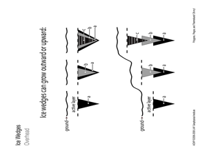
Students complete activities to learn about the common land features in Alaska. In this land study lesson, students study an overhead for permafrost features. Students define ice wedge polygons, thermokarst, and pingos. Students also...
Curated OER
To Protect Your Streams, Protect Your Mountains
Students build and experiment with a watershed to understand the effects of pollution. In this movement of water instructional activity, students work in groups creating rock formations and change the viscosity of the liquids falling...
Curated OER
Mapping The Ocean Floor
Young scholars explore and analyze the bottom structure of underwater habitats. They describe and explain what can't see through the collection and correlation of accurate data. Learners assess that technology is utilized as a tool for...


