Curated OER
Maps and Globes
First graders complete a unit on map skills and the globe. They label maps, create a styrofoam ball globe, create a map of their community, sing a continent song, and complete a map and globe assessment worksheet.
Curated OER
Geography Worksheet
In this geography skills worksheet, students respond to 14 short answer questions by using maps and atlases. The maps and atlases are not included.
Curated OER
English Vocabulary Skills: AWL Sublist 1 - Exercise 3b
In this online interactive English vocabulary skills worksheet, students answer 10 matching questions which require them to fill in the blanks in 10 sentences. Students may submit their answers to be scored.
Curated OER
Where Is Rome?
Third graders discover Ancient Rome through maps and worksheets. In this world history lesson, 3rd graders locate Rome on a world map and identify the scope of the Roman Empire. Students label an entire map of Italy after printing one...
Curated OER
Exploring an Atlas
Students explore global geography by participating in an atlas activity. In this countries of the world lesson, students collaborate in small groups and analyze an atlas while researching continents, countries and demographics. Students...
Curated OER
Kinds of Maps
In this map worksheet, students match a set of descriptions with the names of different types of maps and answer true/false questions and short answer questions about using maps.
Curated OER
Asia Rivers Map Quiz
In this online interactive geography quiz worksheet, students examine the map that includes 18 Asian rivers. Students match the names of the rivers to the appropriate locations on the interactive map.
Curated OER
Outline Map of Japan
In this geography worksheet, students examine a black line outline map of Japan. There is a compass rose on the page. There are no labeled cities.
Curated OER
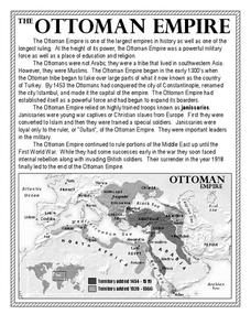
The Ottoman Empire
In this Ottoman Empire worksheet, students read a 1-page selection about the empire and examine a map. Students then respond to 5 short answer questions about the reading selection and the map.
Curated OER
Air Pollution in Mexico City
A fantastic instructional activity on urban air pollution problems throughout the world is here for you. Learners understand that there are many factors involved in creating pollution, that there are many health effects brought on by air...
Curated OER
Asia Map Quiz
In this online interactive geography quiz worksheet, students examine the map that includes 26 Asian countries. Students match the 26 country names to the appropriate locations on the map.
Curated OER
Africa Capitals Map Quiz
In this online interactive geography quiz worksheet, students examine the map that includes 53 African countries. Students match the names of the countries to the appropriate locations.
Curated OER
Continents and Oceans
In this geography activity, students read a paragraph and learn about the seven continents and five oceans of the world. Students study a map of the world and answer 12 short answer questions. This is an online interactive activity.
Curated OER
Asia Crossword
In this geography worksheet, students complete a crossword puzzle on the continent of Asia. They answer 21 questions related to the type of government systems found, capital cities, deepest lake, and lowest population density.
University of California
The Vietnam War (1945 – 1975)
Have you ever wanted to do something so perfectly you wound up not doing it well at all? Young historians use primary and secondary documents to analyze the United States involvement in the Vietnam War. The issues surrounding the...
Curated OER
Map of Asia
In this map worksheet, 3rd graders will study a map of Asia. Students will use this map to label and/or familiarize themselves with various aspects of the continent.
Curated OER
Put the Mountains on the Map
Students discuss what they know about the regions where snow leopards live. They observe the worksheets to see if they can identify any of the mountain ranges and then use atlases to check and complete the country identification worksheet.
Curated OER
Asia Lakes, Rivers, Bays, and Seas Map Quiz
For this online interactive geography quiz worksheet, students respond to 35 identification questions regarding Asia's lakes, rivers, bays, and seas.
Curated OER
Asia Seas Map Quiz
For this online interactive geography quiz worksheet, students respond to 18 identification questions regarding the seas of Asia.
Curated OER
Asia Lakes Map Quiz
In this online interactive geography quiz activity, students respond to 6 identification questions regarding specific lakes located in Asia.
Curated OER
Asian Mountains Map Quiz
In this online interactive geography quiz worksheet, students respond to 17 identification questions regarding the mountain ranges of Asia.
Curated OER
World Map Labels
In this geography skills worksheet, students identify the countries and bodies of water labelled on the maps of the world, Africa, Asia, Canada, Europe, the Caribbean, the Middle East, North America, Australia, and South America.
Curated OER
Latitude and Longitude
In this latitude and longitude worksheet, students complete 4 activities to demonstrate understanding. Students use a protractor to measure angles on a map of the earth. Students fill out a latitude and longitude chart after studying a...
Scholastic
Reading Characters
Philip Pullman's The Golden Compass provides the text for a study of how writers bring characters to life. Using the provided character mapping worksheets, readers respond to questions and then write a short character sketch.


