Curated OER
Landforms: Geomorphology of Arkansas
Second graders create large, salt dough maps of Arkansas and the natural regions in the state created by geographical and morphological features.
Curated OER
The Coldest Place at the Bottom of the World
Students research and trace Shackleton's actual and intended route on an area map. They analyze the altitude changes involved in a trek across Antarctica and complete a worksheet comparing Antarctica to their own state.
Curated OER
Oceanic Heat Budget Activities
Students map and research imaginary islands located in different parts of the world. They describe the weather and climate of their island and show how local currents, water temperatures and waves may influence the weather patterns.
Curated OER
Angular Velocity: How Long Is a Day on The Sun?
Students establish the angular velocity of the Sun and determine how long it takes the Sun to make one complete revolution. They determine what angular velocity is and how it can be useful in determining the speed and direction of any...
Curated OER
Lesson Design Archaeology- Measuring Distance
Students measure and write specific metric distances. In this archaeology lesson plan, students are given specific artifact locations on a map and measure the distance using millimeters.
Curated OER
The Díne (Navajo) Native American Tribe
Students participate in a variety of activities to become familiar with the Navajo Indians. In this Díne (Navajo) Native American tribe lesson, students understand where the Navajo tribe lived and find them on a map. Students discuss the...
Curated OER
The Path of the Black Death
Students are able to show on a map how the Black Death moved through Europe. They summarize the direct effects of the Black Death in Europe. Students cite evidence from firsthand accounts in developing an argument that connections can,...
Curated OER
Book: First Encounters Between Spain and the Americas: Two Worlds Meet
Students, after reading Chapter 1 in the book, "First Encounters Between Spain and the Americas: Two Worlds Meet," design and create a map of the Aztec Empire at the time of the first contract with the Spanish. They create the map from...
Curated OER
The American Trail System
Students research a trail system. They create a display board of the trail system, generate a map of the trail system, and develop a commercial advertising of the trail system. They design a display board featuring facts about the...
Curated OER
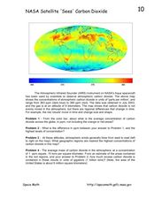
NASA Satellite 'Sees' Carbon Dioxide
For this atmospheric carbon dioxide worksheet, students observe a map showing the concentrations of atmospheric carbon dioxide taken by the Atmospheric Infrared Sounder instrument. Students solve 4 problems using the map. They determine...
Curated OER
Students Slide to School on Air-Powered Sled
Students locate the Great Lakes on a US map, then read a news article about a sled being used as a wintertime school bus in Wisconsin. In this current events lesson, the teacher introduces the article with a map and vocabulary activity,...
Curated OER
"Asking for Tourist Information" (Italian)
Learners explain and use verbal directions, recognize the prepositions used in a conversation, explore Italian art, and acquaint themselves with tourist services in Italy.
Curated OER
Marco Polo Takes A Trip
Students identify Marco Polo and discuss why he took his trip, indicate on map routes Marco Polo took to China and back, describe challenges of traveling along Silk Road, list several interesting aspects of 13th Century Chinese culture,...
Curated OER
Name the States Worksheet 5
In this name the states activity, students examine 6 state map outlines and identify each of them by writing the state names and postal abbreviations.
Curated OER
Alexis de Tocqueville’s America
Students analyze de Tocqueville's America. In this democratic history lesson, students use primary sources to determine what de Tocqueville found to be so unique in the America. Students analyze artifacts, maps and documents through...
Curated OER
Hatsiatsia Music
In this music worksheet, students learn about the rhythms of Hatsiatsia music. Students read about different instruments and facts about Ghana and see a map of the African continent.
Curated OER
New Food Saves Lives, Could End Hunger
Learners locate the country of Niger, then read a news article about a new type of food that is being used to fight childhood hunger in Africa. In this current events lesson, the teacher introduces the article with map and vocabulary...
Curated OER
Early Explorers
Fifth graders study early explorers. In this World history lesson, 5th graders draw an outline of a map labeling each part, build geographical features out of dough, and paint each of the land and water features.
Curated OER
Helping Right Whales - Right Now
In this whales worksheet, young scholars answer eight questions referring to the right whales found in the Atlantic Ocean. Students read a map to answer three questions and five questions are multiple choice.
Curated OER
Lesson Plan on Migration
Fourth graders diagram written and oral directions of a Native American, European Viking, Right Whale or Humpback Whale migration route, the student diagram all directions only in the sequence given, with arrows indicating direction of...
Curated OER
Where in My World Am I?
Students determine exactly where they are in the world by using a local map to write accurate directions to local eating establishments. They write precise directions from the school to their home which the teacher simulates driving to...
Curated OER
Where Is Hoku?
Students are introduced to map making and reading. Using maps, they identify the cardinal directions and discuss the importance of a legend. They analyze the human characteristics of the classroom and create overhead view maps of the...
Curated OER
Finding Important Community Sites
Students locate community sites on a city map using the map legend and grid system.
Other popular searches
- Middle East Maps
- Blank Middle East Maps
- Middle East Maps Trade
- Ancient Middle East Maps
- Medieval Middle East Maps
- East Asia Geography Maps
- Middle East Maps Puzzles
- Far East Maps
- Maps South East Asia
- East Africa Maps
- Sou East Asia Maps

