Richmond Community Schools
Map Skills
Young geographers will need to use a variety of map skills to complete the tasks required on this worksheet. Examples of activities include using references to label a map of Mexico, identify Canadian territories and European...
Curated OER
How To Read A Map
For this map skills worksheet, students view a map and answer five short answer questions by using the map key as a...
Curated OER
New Mexico Map
In this state maps worksheet, students identify the state of New Mexico. Students fill in the state capital, major cities, and other state attractions.
Curated OER
Mexico: Political Map
In this Mexico political map worksheet, students examine state boundaries. The map also highlights major cities in Mexico.
Curated OER
New Mexico cities
In this New Mexico worksheet, students write the cities of New Mexico inside the state including the capital. Students write 8 cities in New Mexico.
Curated OER
Mexico Map
In this blank outline map worksheet, students study the political boundaries of the North American country of Mexico. This map may be used in a variety of classroom activities.
Curated OER
Mexico Map
In this blank outline map worksheet, students study the political boundaries of the North American country of Mexico. The capital cities of each state are denoted with stars.
Curated OER
Mexico Outline Map 2
In this outline map worksheet, students discover and investigate the North American country of Mexico. This blank outline map may be used for a variety of classroom activities.
Curated OER
Mexico and Central America Map
In this blank outline map activity, students study the political boundaries of Mexico and Central America. Each of the counties is labeled and the capital cities are starred.
Curated OER
Mexico: Political Map
In this Mexico political map worksheet, students examine state boundaries. The map also highlights major cities in Mexico. This map is unlabeled.
Curated OER
Mexico and Central America Map
In this outline map worksheet, learners study the political boundaries of Mexico and the Central American countries. This map is labeled with the country names.
Curated OER
Central America Outline Map
In this Central American political map worksheet, students make note of national boundaries and capitals in this region of the world. National capital city locations are noted with stars.
Curated OER
North America: Political Outline Map
In this North America political map worksheet, students examine the state and province boundaries of Mexico, Canada, and the United States.
Curated OER
Topographic Maps Worksheet
In this geography skills worksheet, students respond to 37 multi-part questions that require them to read and interpret topographic maps.
Curated OER
School-Home Link: Maps
In this atlas and parent communication form worksheet, students use an atlas to find several things: the capitol city of Japan, the number of countries in Africa, where to buy a newspaper, the names of Presidents of the United States,...
Curated OER
Mystery State #38
In this United States mystery worksheet, students determine which state is described by the 5 clues listed on the sheet and then mark it on the outline map of the United States.
Curated OER
North American Biomes
In this Science worksheet, students color a biome map of North America. Students color the map by solving the clues listed on a separate sheet of paper.
Curated OER
United States: Physical Features Fun
In this map worksheet, learners color and trace eleven listed features on a map of the United States. Students answer six additional questions about the map. A United States map is not provided. However, websites are provided to find...
Curated OER
Mapping Mexico
In this Mexico map activity, learners label features and places on a blank map of Mexico. A reference web site is given for additional activities.
Curated OER
Mexico History Worksheet
In this Mexico history worksheet, students examine a map of the states in Mexico and a blank timeline from 3000BC to the future. There are primary lines provided to write on, but no student directions.
Curated OER
Identifying Border States of the U.S.
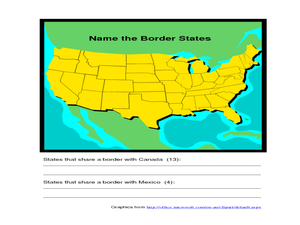
For this identifying border states of the U.S. worksheet, 3rd graders visually identify then write the names of the states that border Canada and Mexico; page 1 is a lesson, page 2 is the worksheet.
Curated OER
State to State Scavenger Hunt
In this states activity, students utilize the Internet to access one specific website to locate the answers to five fill in the blank statements about the states found on a United States map.
Curated OER
Biome Map
In this biomes activity, students color the map of North America according to the biome clues. Students then answer questions about the North American biomes.
Curated OER
Mapping the United States
In this map of the United States worksheet, students label mountains, surrounding countries, oceans, and more. Students complete 12 tasks.


