Curated OER
Draw To Scale The E-Z Way
Fourth graders draw a rough floor plan of a house to scale without using a ruler to determine measurements. They see how architects use scale to draw blueprints, and solve math problems using scale.
Curated OER
3-D Model of Lake Benthos
Students create 3-D models of Lake Benthos. In this scale drawing lesson, students create a 3-D model of Lake Benthos. Students work in groups to create the models. Students use the models to to encourage people to conserve natural...
Curated OER
Make a Map
In this mapping activity worksheet, students finish the map by following the 5 directions and using the map key. Students the map key, scale, and an inch ruler for help.
Curated OER
Playground Mapping
Young scholars review their physical models of the objects on their playground at school. Using the model, they convert it into a map with a scale and key. To end the lesson, they use the map to locate different objects and measure the...
Curated OER
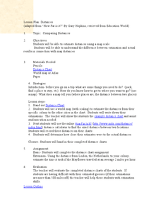
Comparing Distances
Students practice estimating distances by analyzing a map. In this length measurement lesson, students view a map with a distance key and use their measurement skills to estimate the distance between two cities. Students utilize an...
Curated OER
Painting the Hallway with Pixels
Middle schoolers create science design to be painted on the wall in the hallway of the science area of the school building. They measure space available, make a scale model of the design, and paint different pixels.
Curated OER
Living in the Desert
Conduct an investigation on the plants used by the Hohokam tribe. To survive in the harsh desert environment the Hohokam used many natural resources. Learners read, research, map, and graph multiple aspects of Hohokam plant use as a...
Curated OER
GPS Art
Students design their own logo or picture and use a handheld GPS receiver to map it out. They write out a word or graphic on a field or playground, walk the path, and log GPS data. The results display their "art" on their GPS receiver...
Curated OER
Cartography
Students follow directions to draw a map of an island. They complete the island map adding their own details using symbols and a legend.
Curated OER
It's Greek to Me!
Students explore Greek Mythology. In this Greek Mythology unit, students read myths, pantomime vocabulary words, practice research skills, create city-states, and demonstrate knowledge of ratios and proportions. This unit includes many...
PBS
Home, Sweet, Home!
Students investigate the local history and architecture of their community. They draw maps, conduct Internet research, discuss varied architectural designs, take a walking tour of their town and work in teams to record their community's...
Curated OER
Castle Builder
Fifth graders discuss the importance of castles in medieval times. Using the internet, they research the parts of a castle and design their own using the components. They use everyday materials to build the castle to a specific scale.
Curated OER
Know Your Area
Students investigate transit by analyzing their school surroundings. In this local geography lesson, students identify their school in relation to the rest of their state, country and globe. Students discuss their personal travel habits...
Curated OER
Investigation: The Local Bagel Shop
Sixth graders explore economics by solving business math problems. In this ratio and proportion lesson, 6th graders examine different meals to be purchased at a coffee shop and compare which prices make which meals a better purchase....
Curated OER
Exploring History Through Photographs
Fifth graders compare and contrast photographs from the 1800s to those of 2003. In groups, they create drawings of how society has changed over time and use maps to locate local streets. Individually, they practice measuring the...
Curated OER
Landscapes
Learners explore landforms and landscapes. They demonstrate an appreciation for and examine how to recognize the attributes of landforms and landscapes. Students create a landscape and reflect on their painting.


