Curated OER
Weather Maps and Prediction
Young meteorologists read basic weather maps by learning about the symbols that are associated with them. This two-day lesson has some excellent demonstrations and activities to get youngsters thinking about the weather in scientific...
Curated OER
Reading Weather Maps
Fourth graders the symbols that are used on weather maps. They develop five day forecasts based on information they gather from weather maps in the newspaper and on the Internet.
Curated OER
Weather Forecasting
Students discover how to read a current weather map. In this weather forecasting instructional activity, students view weather maps from three consecutive days and observe how quickly weather moves and changes. Students review key terms...
Curated OER
Weather Maps and Prediction
Second graders point out symbols for high and low pressure that would be found on weather maps. They break into small groups and use a copy of the weather maps file to make observations about the maps and come up with an explanation of...
Curated OER
Reading a Local and National Weather Map
Students investigate weather maps. In this weather lesson plan, students discover the meaning of different weather icons and symbols. Working independently, students use the local forecast to correctly label a state map.
Curated OER
Weather Reporting
Students locate a weather map on the internet and explain or predict the weather for the following day. Students interpret the information on the weather map and pick the correct clothing to wear for that day. Students chart and graph...
Curated OER
Reading a Local and National Weather Map
Young scholars examine weather maps. They examine icons and map symbols. Students explore vocabulary words related to weather. Young scholars analyze and evaluate information provided on the weather map.
Curated OER
Reading a Local and National Weather Map
Students practice reading a national and local weather map. Using this information, they work together to make predictions about the weather for the next few days. They discuss the use of symbols and maps as a class and discuss how...
American Institute of Physics
The Tuskegee Weathermen: African-American Meteorologists during World War II
Chances are good that young scholars have heard of the Tuskegee Airmen but few would predict that these pilots had their own support in the form of the Tuskegee Weathermen. These Black meteorologists were recruited and trained to provide...
Curated OER
The Weather
Students explore earth science by reading articles in class. In this weather identification lesson, students analyze weather science articles on the Internet and view their own local weather patterns as well. Students define a list of...
Curated OER
Weather Reporter
Fourth graders generate an oral presentation on the weather. In this weather lesson plan, 4th graders watch the weather for a week and record the data on a chart. Students give a weather report at the end of the week.
Curated OER
Predicting Storms and Weather
Young scholars use weather pattern worksheets to research how weather is predicted. In this weather prediction lesson plan, students predict the weather based on the wind, rain, currents, and other patterns.
Curated OER
Storm Clouds-- Fly over a Late Winter Storm onboard a NASA Earth Observing Satellite
Students study cloud data and weather maps to explore cloud activity. In this cloud data lesson students locate latitude and longitude coordinates and determine cloud cover percentages.
Curated OER
Weather Forecast
Students explore the vocabulary for making statements about the weather in various cities. They respond with the use of the appropriate interpretive strategies to show the directions in the taget language for placing weather symbols on...
Curated OER
Weather Reporter
Fourth graders explore the components of a weather map, mark cities on the map and place the appropriate temperatures and weather conditions occurring in the cities on the weather map created.
Curated OER
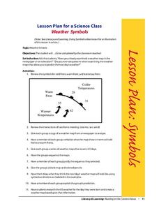
Weather Symbols
Students study weather symbols. In this weather symbols instructional activity, students review the symbols for cold, warm, and stationary fronts. Students use a weather map to study the weather symbols, complete a weather illustration...
Curated OER
Creating Station Models
Students work in groups to interpret weather maps. They use latitude and longitude readings to complete a worksheet together and turn in the worksheet along with the maps and a rubric.
Curated OER
Weather
Fourth graders study a map and locate cities, read information and create a chart. In this weather lesson students place appropriate weather information on a map and write a script using their information to relay the weather to the...
Curated OER
Weather Forecasting Basics
Eighth graders analyze weather diagrams and weather maps. In this earth science lesson plan, 8th graders explain why it is important to know the weather. They complete a handout at the end of the lesson plan.
Curated OER
Weather and Climate
Students identify the words plain and climate and discuss what would happen if it never rained. Students identify and interpret the weather in Poland and create a web illustrating various weather patterns. Students write a 4-line poem...
Curated OER
Circle the Earth - Explore Surface Types on a Journey around Earth
Students use CERES percent coverage surface data with a world map in locating landmasses and bodies of water at Earth's Equator.


