Curated OER
What is the Rock Cycle and Its Processes?
Geology beginners examine three different rock samples and determine their origin by their characteristics. By making and recording observations, they become familiar with features of igneous, metamorphic, and sedimentary rock types....
Curated OER
Adventures With Maps And Globes
First graders examine the differences between a map and a globe. They discuss and identify the symbols on maps and globes, then in small groups complete a worksheet. Students then complete a Venn Diagram comparing maps and globes.
Curated OER
America Will Be
Students work together to research and create different types of maps of the United States to be used as part of a geography trivia game.Groups research North American annual rainfall, climate, mountain ranges major rivers and state...
Curated OER
GIS Mapping: Special Instructions for Using Digital Orthophotos
Students practice cartography using GIS technology. They create a map of Austin using GIS and aerial photos.
Curated OER
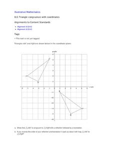
Triangle Congruence with Coordinate
Two triangles are displayed on a coordinate plane. Youngsters apply a reflection and a translation to demonstrate their congruence. This exercise makes a terrific tool for teaching these concepts, or a way to assess learning.
EngageNY
Getting a Handle on New Transformations 2
Use 2x2 matrices to move along a line. The second day of a two-day lesson is the 28th installment in a 32-part unit. Pupils work together to create and solve systems of equations that will map a transformation to a given...
EngageNY
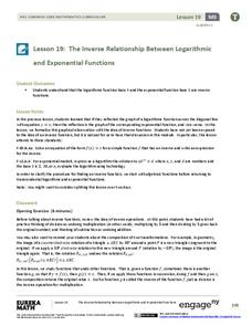
The Inverse Relationship Between Logarithmic and Exponential Functions
Introducing inverse functions! The 20th installment of a 35-part lesson encourages scholars to learn the definition of inverse functions and how to find them. The lesson considers all types of functions, not just exponential and...
Curated OER
Where People Live- Neighborhoods
Students use a map. In this neighborhood lesson, students describe a neighborhood, emphasizing the common characteristics between all neighborhoods. Students locate a neighborhood on a landscape picture map and discuss.
Curated OER
On the air! Interviews
In this mock interview lesson, students view pictures of famous personalities and determine which of these personalities they would like to interview. Students follow the three step interview process and conduct a mock interview...
Curated OER
Who's The Boss?
Upper elementary and middle schoolers research and analyze some different types of governments. Democracies, Monarchies, and Dictatorships are some of the types that are looked at. Learners use the Internet to gather information that...
Ocean Explorer
Looking for Clues
Upper graders become "shipwreck detectives" by studying the debris field from a shipwreck in the Aegean Sea which took place in the 700s. A website is accessed that gives specific information about the debris field, and pairs of...
Curated OER
The Great Topo Race
Students create a three dimensional island out of cardboard to examine how to read and use a topographical map. They make sure that their island can sustain life and that it has one volcanic mountain peak. They trace the parts of their...
Curated OER
Breads Around the World
Pupils read about bread. In this instructional activity studying bread, students read about the history of bread and it's significance around the world. Pupils identify the three main crops used to make bread and ten common types of...
Curated OER
Flipping Over Our Weather Reports
Students create their own weather report. In this weather lesson, students work in groups to predict the weather for three days and create their own video. They have a director, camera-person, still cameraman, and two weathermen.
Curated OER
Community
Second graders draw a picture. In this communities lesson plan, 2nd graders read the book Communities, and review as they read. Students use construction paper to create a picture of their houses in three different communities including...
Curated OER
A Colony is Born : Lesson 6 -To Leave or Not to Leave
Fifth graders connect reasons for coming to the New World with identity. The create identities and place them in one of three settled regions. They refer to prior study notes in their Colonial Notebooks to establish their identities.
Curated OER
Compass Rose Directions
Second graders use cardinal and intermediate directions to locate places on maps and places in the classroom, school, and community. They draw a setting map of "Little Red Riding Hood." Students give five steps of cardinal or...
Curated OER
Ancient Egypt: Connecting Literature and Geography
Students brainstorm prior knowledge of Ancient Egypt, locate Egypt on map of Africa and on world map, watch King Tut film, discuss term biography, and map geographical information mentioned in stories and documentaries about Ancient Egypt.
Curated OER
All Aboard!
Students research the history and background of snowboarding as well as the two main types of competition; the Giant Slalom and the Halfpipe. They find the schedule of past and future events and plot the locations of as many of these...
Curated OER
Homes Around the World
Pupils investigate houses and homes from around the world and create a map collage. They compare how the homes are similar and different and why houses match the weather and geography.
Curated OER
You Too Can Haiku
Students explore the country of Japan. For this international studies lesson, students utilize their geography skills to locate Japan on a map. Students explore some Japanese customs and communities. Students use descriptive...
Teaching Adapted PE
Locomotor and Object Control Stations
Develop children's basic locomotor and object control skills with an invigorating Adaptive PE lesson. A series of four, timed stations engaged the class in playing a game of Twister, walking on a balance beam,...
Curated OER
Types of Transportation
Students study different types of transportation including specialized trucks. In this transportation lesson, students look at a landscape picture map (not included) and identify all of the modes of transportation they see. They see...
Curated OER
Mapping Seamounts in the Gulf of Alaska
Students describe major topographic features on the Patton Seamount, and interpret two-dimensional topographic data. They create three-dimensional models of landforms from two-dimensional topographic data.


