Curated OER
The Notorious Four-Color Problem
Take a walk through time, 1852 to 2005, following the mathematical history, development, and solution of the Four-Color Theorem. Learners take on the role of cartographers to study a United States map that is to be colored. One rule: no...
Curated OER
Touring the Regions of the United States
Fifth graders explore the regions of the United States. They use maps, research on the Internet and use measurements and estimations. Students create a presentation using spreadsheets and publishing software.
Curated OER
Project Whistlestop:Missouri Vacation Learning Unit
Fourth graders reserach the state of Missouri. In this Missouri History lesson, 4th graders plan a vacation to a region of Missouri. Students work in collaborative groups to determine all aspects of the trip. Students use math skills for...
Education World
The African American Population in US History
How has the African American population changed over the years? Learners use charts, statistical data, and maps to see how populations in African American communities have changed since the 1860s. Activity modifications are included to...
MARS, Shell Center, University of Nottingham
Defining Regions Using Inequalities
Your young graphers will collaboratively play their way to a better understanding of the solution set produced by the combining of inequalities. Cooperation and communication are emphasized by the teacher asking questions to guide the...
Curated OER
How Big is Big?
Geography learners compare and contrast population densities throughout the world. Using maps, they estimate the relative size of the world's regions and populations. They develop analogies to discover the world they live in and...
California Academy of Science
California's Climate
The United States is a large country with many different climates. Graph and analyze temperature and rainfall data for Sacramento and Washington DC as you teach your class about the characteristics of Mediterranean climates. Discuss the...
Curated OER
Civil War and Reconstruction
Students examine the differences between the North and South during the pre-Civil War era. In this Civil War era lesson plan, students spent 7 days looking at things that were different between the Union and Confederate state before the...
Curated OER
Weather Watchers
Students are introduced to an Underground Weather Stations. In groups, they use the internet to research the weather in different parts of the United States locating each city. To end the lesson, they summarize the information they...
Curated OER
Places and Production
Students calculate United States GDP and GDP per capita, use a choropleth map to acquire information, and create choropleth maps of GDP per capita in South America. They identify regions with high and low GDP per capita
Curated OER
Spatial Connections
Students use maps, scales, and describe locations in order to learn about spatial sense. In this spatial sense lesson plan, students participate in many activities for this spatial sense unit that should last throughout the year.
Curated OER
Geography Journey
Fourth graders examine the geographic features that define places and regions and answer questions about the state of California. They discuss the components of a map legend and answer worksheet questions using a map of California as a...
Curated OER
People On The Move
Students describe patterns of internal migration in the United States, past and present and evaluate implications of internal migration. They examine population movement at the state and local levels.
Curated OER
High and Low Tides
Students collect real world data from the Web regarding high and low tides at various locations in the United States. They find a function which models this data and make predictions on tide levels based on the information found.
Curated OER
Individualizing
Students practice reading maps as they plan a day trip. Using the internet, they select a destination of their choice and choose a place to stop along their journey. They write an explanation on why they want to visit the place to end...
Curated OER
Cruisin' the Counties: Learning Counties and Major Roads in Arizona
Learners examine Arizona counties and use the themes of location and movement to develop an Arizona map.
Curated OER
Westward Expansion
Students locate California and New York on a map and explore available means of travel in the 19th century. Students explore the role of trade in pioneer America and simulate various barter transactions.
Curated OER
Climate Systems - Which Location Is Best For Me?
Students study the difference between weather and climate. In this climate systems lesson students search the Internet for the parts of the Earth's system, gather climate data and complete a challenge scenario.
Curated OER
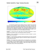
NASA Satellite 'Sees' Carbon Dioxide
In this atmospheric carbon dioxide worksheet, learners observe a map showing the concentrations of atmospheric carbon dioxide taken by the Atmospheric Infrared Sounder instrument. Students solve 4 problems using the map. They determine...
Curated OER
World Statistic Day
Eleventh graders collect data about the state they live in. For this statistics lesson, 11th graders collect and analyze data as they compare themselves to students in other states. They analyze data about a person's education level, and...
Curated OER
Stopping Along the Way
Students use atlases, maps, and Web resources to plan a day trip to at least one city or point of interest that is on the way to their final destination.
Curated OER
50 State Quarter Game
Learners, using their knowledge of place value and number sense, play this counting game in small groups, or as a whole class, to see who be the first person to reach 50 cents.
Curated OER
Places and Production
Students investigate the economy and the market value of goods. For this algebra lesson, students differentiate between domestic goods value and international good value. The define and identify the importance of GDP or Gross Domestic...
Curated OER
Where in the Usa is Radon?
Students determine the areas of New Jersey and the US that are likely to have high radon concentrations. Students draw a map of their own neighborhood that show soil associations in their neighborhood.


