Mathed Up!
Enlargements
Make enlargements with and without centers. Pupils work through seven problems dealing with dilations or enlargements. The first couple items are strict enlargements without centers, while the others have centers. Class members also...
Balanced Assessment
School Zone
Find the right house within walking distance from school. The short assessment has pupils determine the houses that are a given maximum distance from a school. Individuals then determine the shortest and longest walks from the homes that...
Curated OER
Maps Not Drawn to Scale
In this maps worksheet, students redraw a map to make it more accurate and drawn to scale in the space given. Students draw 1 map and answer 2 questions.
Curated OER
Complex Analysis: Linear Transformations, Inversion Mappings
In this transformation learning exercise, students identify a series of transformations and sketch them. They use inversion mapping to establish a one-to-one correspondence between nonzero points. This four-page learning exercise...
Curated OER
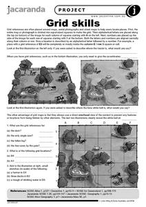
Grid Skills
In this geography worksheet, students use grid references on a map to locate places in the pictures given. They also identify another advantage of using a grid map, which they have an overhead view of the content to prevent any features...
Curated OER
Musical Plates-Earthquakes
In this plotting earthquake data worksheet, learners use a large world map and given web sites showing the latitude and longitude for the epicenter of recent earthquakes around the world. Students plot 2 weeks of earthquake data...
Curated OER
Comparing the New Madrid and San Andreas Fault Zones
In this faults worksheet, students use an earthquake reference sheet to find the numbers for a modified Mercalli and Richter scale. They compare the San Andreas Fault zone and the New Madrid fault zone on the United States map. They...
Curated OER
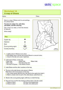
A Map of Ghana
In this Map of Ghana worksheet, students are given a blank map and key. They are told to label major features and color according to directions.
Noyce Foundation
Photographs
Scaling needs to be picture perfect. Pupils use proportional reasoning to find the missing dimension of a photo. Class members determine the sizes of paper needed for two configurations of pictures in the short assessment task.
Curated OER
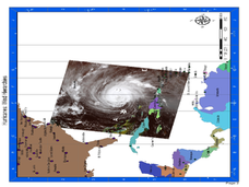
Hurricane Winds: A Spatial Hierarchy of Processes at Different Scales
In this earth science lesson, students study a satellite image of hurricane Isabel and write answers to 5 questions that follow. They match predictions to the map locations.
Curated OER
Measurement 2
In this measurement worksheet, students use liner measure with a provided ruler to determine the distance between objects. Using a map scale, they evaluate the actual distance. Students may use their knowledge of proportions to solve...
Curated OER
Make a Map
In this mapping activity worksheet, students finish the map by following the 5 directions and using the map key. Students the map key, scale, and an inch ruler for help.
Curated OER
Outline Map of Japan
In this geography worksheet, students examine a black line outline map of Japan. There is a compass rose on the page. There are no labeled cities.
Oregon State
World Map of Plate Boundaries
Young geologists piece together the puzzle of plate tectonics in an earth science lesson. Given a physical map of the world, they search for land formations that indicate the location of different types of plate boundaries.
Curated OER
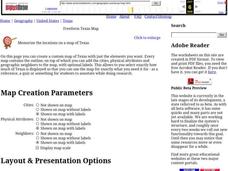
Freeform Texas Map
In this Texas map worksheet, students research, label and discuss the most important cities in Texas, its physical attributes and the states that surround Texas.
Curated OER
Freeform Pennsylvania Map
In this Pennsylvania map worksheet, students research, study and label twenty important cities, physical attributes and the neighbors that surround Pennsylvania on a Pennsylvania map.
Curated OER
Globe Skills Lesson 5
In this map skills instructional activity, students read a text selection about locations during the American Revolution and then respond to 8 fill in the blank questions.
Curated OER
Geography
In this geography worksheet, students answer multiple choice questions about maps, rivers, land, and more. Students complete 20 multiple choice questions.
PBS
History's Most Powerful Plants
At one point, scale trees accounted for nearly half of the biomass in North America and Europe. An installment of a longer video series introduces these strange plants and describes their features, adaptations, and eventual demise. It...
Curated OER
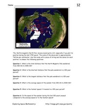
Earth's Magnetic Pole
In this Earth's magnetic pole learning exercise, students use a diagram showing the changes in the magnetic pole of the Earth over time. Students use the given scale of the changes to answer 6 questions about the average speed of the...
Curated OER
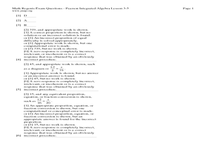
Lesson 3-5: Proportions and Similar Figures
For this similar figures worksheet, students use proportions to solve 6 short answer and multiple choice questions. Students use proportions to answer questions about map scales and height of trees given shadow lengths.
Curated OER
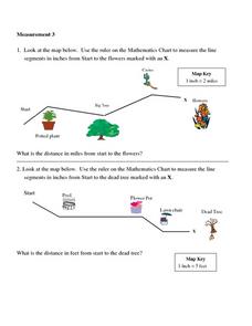
Measurement 3: Rulers
In this measurement worksheet, students measure the linear distance, in inches, between stated objects. Next, they determine the actual distance, in miles.
EngageNY
Properties of Dilations
Investigate dilations to learn more about them. The second segment in a series of 16 provides a discussion of properties of dilations by going through examples. The problem set provides opportunities for scholars to construct dilations.
TED-Ed
Visualizing the World's Twitter Data
Watch as Jer Thorp, former analyst for the New York Times, presents models of human behavior based on Twitter activity. Use the video to show your class the impact and scale of social media during a technology unit. The presenter is...


