Curated OER
Mapping the United States
In this map of the United States worksheet, students label mountains, surrounding countries, oceans, and more. Students complete 12 tasks.
Statistics Education Web
The United States of Obesity
Mississippi has both the highest obesity and poverty rate in the US. Does the rest of the data show a correlation between the poverty and obesity rate in a state? Learners tackle this question as they practice their skills of regression....
Curated OER
States in the USA Quiz
In this online interactive geography quiz learning exercise, students respond to 50 identification questions about the states in the United States of America. Students have 4 minutes to complete the quiz.
Curated OER
United States Map: March 31
For this calendar dates worksheet, learners learn that March 31st was the day the first map of the United States was published. Students then create a map of either their classroom or school.
Curated OER
U.S. Geography for Children: State Capitals
In this United States map skills instructional activity, students locate and label specified states and their capitals, and create icons and a map key to show something for each state that is famous. Students answer 5 questions.
Curated OER
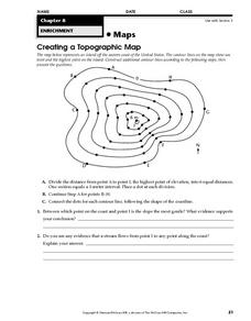
Creating a Topographic Map
In this topographic map activity, students add contour lines to a topographic map using instructions provided. Once topographic map is finished, students complete 2 follow-up short answer questions.
Curated OER
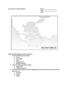
Ancient Greece Map Worksheet
Since the beginning of time, geography has shaped the development of human civilization, and ancient Greece is no exception. This activity supports young historians with exploring this relationship as they first identify key land masses,...
Curated OER
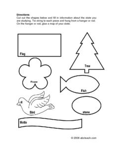
State Information
In these research worksheets, students will discover facts about one of the fifty United States. They are asked to research seven facts about their state including the state bird, state motto, and state flower. Students then create a...
Curated OER
Student Exploration: Building Topographic Maps
For this earthquake exploration worksheet, students complete 2 prior knowledge questions, then use "Building Topographic Maps Gizmo" to conduct several activities, completing short answer questions when finished.
Scholastic
Volleyball Road Trip
Review coordinate mapping with your young geographers by matching cities on a volleyball team's road trip itinerary to their appropriate coordinate locations.
Cornell University
Too Much of a Good Thing?
Continuing their study of beneficial insects, young entomologists discover where in the world some of these bugs are. By labeling, coloring, and using the scale on a map, pupils explore the territories and arrival of the Asian lady...
Curated OER
Tears of Joy Theatre Presents Anansi the Spider
Accompany the African folktale, Anansi the Spider, with a collection of five lessons, each equipped with supplemental activities. Lessons offer multidisciplinary reinforcement in English language arts, social studies, science, and arts...
Curated OER
U.S. Geography for Children
In this U.S. map activity worksheet, students observe maps of the continental United States, Hawaii, and Alaska, locate and label landforms and bodies of water, and create symbols for natural resources and places of interest. Students...
Education World
Mystery State #29
In this United States mystery worksheet, young scholars determine which state is described by the 5 clues listed on the sheet and then mark it on the outline map of the United States.
Curated OER
Ohio Vocabulary
After selecting State Unit Studies and choosing Ohio, you'll find a plethora of information on The Buckeye State. There's an information sheet, an Ohio state map, and several sheets that detail the capital, flag, flower, bird, tree,...
Curated OER
U.S. Geography for Children: The Northeast
In this map skills of the northeastern United States worksheet, students observe an outline map, locate and label the states, and designated landforms and bodies of water; and create symbols and a map key for sources of economy and other...
Illustrative Mathematics
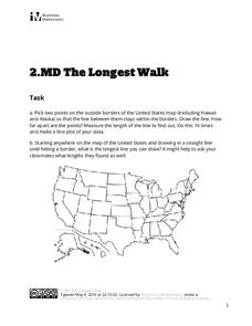
The Longest Walk
How long of a line can you draw within this activity? Learners pick two points outside and within the map to create the longest line they can. After drawing 10 lines, learners plot the length of each line on a line plot. Then they...
Curated OER
U.S. Commonwealths and Territories
In this Puerto Rico worksheet, students follow directions to create icons and label cities on a map of Puerto Rico. Students follow 5 sets of directions.
Curated OER
Florida: U.S. Geography for Kids
In this Florida geography worksheet, students locate and label the important features of Florida and create icons for the economy and culture of Florida.
It's About Time
Energy from Coal
If plastic is derived from fossil fuels and fossil fuels come from dead dinosaurs, does that mean that plastic dinosaurs are made from real dinosaurs? This lesson goes into depth about coal and other fossil fuels. First the instructor...
Curated OER
Maryland Vocabulary
After selecting State Unit Studies and clicking on Maryland, you'll be directed to a page with several useful links! You'll get basic state facts, a map of the state, and information on the flower, capital, flag, bird, dog, cat, etc! So...
Curated OER
Biggest Metro Areas in the USA
In this online interactive geography quiz worksheet, students respond to 100 identification questions about metropolitan areas in the United States. Students have 10 minutes to complete the quiz.
Curated OER
Hottest US Cities Quiz
In this online interactive geography quiz worksheet, learners respond to 20 identification questions about the hottest cities in the United States. Students have 4 minutes to finish the timed quiz.
Curated OER
Coldest US Cities Quiz
In this online interactive geography quiz worksheet, students respond to 20 identification questions about the coldest cities in the United States. Students have 4 minutes to complete the quiz.


