Random House
Mapping Skills
Spark interest and enhance your pupils' map skills using Matteo Pericoli's book, See the City: the Journey of Manhattan Unfurled. Through Pericoli's illustrations and text, learners explore the East and West side of Manhattan. Then,...
Richmond Community Schools
Map Skills
Young geographers will need to use a variety of map skills to complete the tasks required on this worksheet. Examples of activities include using references to label a map of Mexico, identify Canadian territories and European countries,...
abcteach
Street Mapping
What's around the block? Or down the street? Ask your pupils to tap into their map skills by drafting the area around their home and school.
Luminations Media Group
Geography: Map Reading Basic Skills
Enhance scholars' map skills using this activity displaying the land of Kahitsa’an from the series, The Realm, by K.L. Glanville. The activity helps readers visualize the make believe-land, examine its attributes, and answer 10 short...
Curated OER
Getting to Know Austria- Map Skills
In this Austria map skills worksheet, students apply map skills to answer 14 fill in the blank questions about the country. They determine border countries, identify regions, find the capitol, and name rivers. They draw a map of Austria...
Curated OER
Determining Direction With A Map- Online Interactive
For this map skills worksheet, students analyze a city map and study the compass rose. Students answer 10 questions about the map. This is an online interactive worksheet.
Curated OER
Map of Africa
Using a completed map (not provided), pupils will use this map to fill in the geographic features of Africa. An appropriate map can be printed using the Internet and placed under a document camera for the class to reference.
Scholastic
Volleyball Road Trip
Review coordinate mapping with your young geographers by matching cities on a volleyball team's road trip itinerary to their appropriate coordinate locations.
Education World
Map Skills Worksheet 5
In this map skills practice worksheet, students practice reading a legend as they respond to 12 short answer questions regarding a legend and a map.
Curated OER
Make Your Map
In this map making learning exercise, students make their own maps, draw symbols and place them in the map key area, and draw a compass rose to show directions for the map.
Curated OER
Compass Rose
Keep it simple and visual when practicing directions using this compass rose labeling activity. Learners fill in the compass themselves, using cardinal and intermediate direction abbreviations. Consider using their compass on a map to...
Curated OER
North Dakota Map
In this North Dakota instructional activity, students study an outline map of North Dakota with the capital city marked. Students color the map and add other important cities and landmarks.
Curated OER
Sir Francis Drake
Help your learners prep for an exam testing content knowledge related to Florida's State History. Your class can use this printable page to review vocabulary, identify locations on a map, and research both knights and the Sir Francis...
Curated OER
Across the United States- Home Learning Activity
In this home-school United States map worksheet, students work with a family partner as they study a map of the United States. They talk about the states they have visited, play a game by giving each other clues about states, and write...
Curated OER
Global History & Geography: Latin America
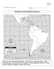
The instructions say to use a text-book to label 11 different regions in modern Latin America. If a text-book is not available a map can be found on-line and printed for student reference.
Curated OER
The Roman Empire-Map Activity
In this Roman Empire worksheet, students complete a map activity in which they label and color civilizations, countries and physical features as instructed. There are no maps included.
Curated OER
Kinds of Maps
In this map worksheet, students match a set of descriptions with the names of different types of maps and answer true/false questions and short answer questions about using maps.
Curated OER
Australia Map Skills
For this Australia map worksheet, students research, find and label the following cities: Canberra, Sydney, Darwin, Brisbane, Adelaide, Hobart, Melbourne and Path.
Curated OER
Learn the States and Postal Abbreviations
If you are preparing to cover the 50 states with your class, you don't want to miss this resource. It includes an excellent set of worksheets through which learners practice identifying states from their abbreviations and placing those...
Curated OER
Label the Southern States
During your study of the United States, challenge your class to label the seventeen Southern states. Can they do it without the key? The answer sheet is included.
Curated OER
Map Keys
In this geography worksheet, students identify who a cartographer is and what they do specifically. They study an outline map of a fictitious island and then, respond to the three questions that follow. Finally, students add three more...
Curated OER
Grid Skills
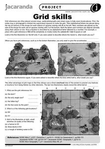
In this geography instructional activity, students use grid references on a map to locate places in the pictures given. They also identify another advantage of using a grid map, which they have an overhead view of the content to prevent...
Curated OER
Where Am I? Map Activity
In this map activity activity, students determine which countries are shown on a set of 16 maps, then read facts about each country designed to help with a report on that country.
Curated OER
The Oregon Trail
For this Oregon Trail worksheet, learners practice their map skills while they explore the states of Oregon, Missouri, Idaho, Nebraska, and Wyoming. Students us a map of the US to plot six points on the map that show the Oregon Trail.


