Curated OER
Mapping My World
Students are introduced to simple maps and view a map of a classroom and compare distances of items shown.
Curated OER
Waldseemuller's Map: World 1507
Seventh graders analyze various maps. In this Geography lesson, 7th graders create a large map as a whole class. Students write a letter to Mr. Waldseemuller.
Curated OER
Maps with a "Spin"
Students, in groups, research and map the effects of a proposed airport three miles outside of town. They prepare a presentation based on a set of maps they make and explains its different points of view from the viewpoints of the town...
MARS - Mathematics Assessment Resource Service
Applying Properties of Exponents
The properties of exponents are all linked together and it is your mathematicians' job to discover and apply those rules. The comprehensive instructional activity begins with a pre-assessment task to check for prior knowledge and then...
Curated OER
GIS Mapping: Special Instructions for Using Digital Orthophotos
Students practice cartography using GIS technology. They create a map of Austin using GIS and aerial photos.
Indian Land Tenure Foundation
More Tribal Homelands
Here is a very fun idea that introduces young learners to how geographical location affects cultural development. They are introduced to four areas where Native Americans have lived in the past by reading stories and examining images....
Science Matters
A Model of Plate Faults
The San Andreas fault is one of the longest fault zones in the world. In a series of 20 lessons, the fourth lesson has pupils use a paper model to recreate various types of plate faults. Each is held in position then drawn...
Curated OER
Regents High School Examination: Physical Setting Earth Science 2006
Test your class on earth science with this extensive resource. This test, created by The University of the State of New York Regents, is made up of 50 multiple choice questions and 32 short answer questions that cover the branches of...
Alabama Learning Exchange
Triangle Congruence with Rigid Motion
Combine transformations and triangle congruence in a single lesson. Scholars learn to view congruent triangles as a rigid transformation. Using triangle congruence criteria, learners identify congruent triangles and the rigid...
Curated OER
Earth's Water
If the majority of our planet is covered with water, why do we need to bother conserving it? With a thorough and varied investigation into the location and types of water on the earth, learners will gain an understanding of why this...
Chicago Botanic Garden
Seed Dispersal and Plant Migration
There are five methods of seed dispersal. They include gravity, mechanical, animal, water, and air. Scholars study seed dispersal in lesson five of the series of six. Through discussions, hands-on analysis of different seed types, and...
Curated OER
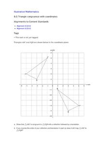
Triangle Congruence with Coordinate
Two triangles are displayed on a coordinate plane. Youngsters apply a reflection and a translation to demonstrate their congruence. This exercise makes a terrific tool for teaching these concepts, or a way to assess learning.
National Wildlife Federation
An Energy Mix: Renewable and Nonrenewable Resources
What did the windmill say about renewable energy? I'm a BIG fan! Lesson three in the series of 12 has classes discuss potential and kinetic energy and then, in pairs, they complete a web quest over the different types of energy...
EngageNY
The Inverse Relationship Between Logarithmic and Exponential Functions
Introducing inverse functions! The 20th installment of a 35-part lesson encourages scholars to learn the definition of inverse functions and how to find them. The lesson considers all types of functions, not just exponential and...
Curated OER
Finding Meaning in the Badge
Children who are three to five years old study two rank badges from the Qing dynasty to develop an understanding of social rank, language skills, and symbolism. The lesson is discussion-based and requires learners to compare and contrast...
Curated OER
An Early American Culture
Students identify the locations of the Hopewell culture. In this map skills lesson, students use a globe to mark several locations of the Hopewell culture.
Curated OER
Ancient Egypt: Connecting Literature and Geography
Students brainstorm prior knowledge of Ancient Egypt, locate Egypt on map of Africa and on world map, watch King Tut film, discuss term biography, and map geographical information mentioned in stories and documentaries about Ancient Egypt.
Curated OER
Changing Images of Childhood in America: Colonial, Federal and Modern England
Students compare and contrast maps of New Haven, Connecticut from today and the past. After taking a field trip, they draw sketches of the types of architecture and discuss how the buildings have changed over time. They read journal...
Curated OER
Angles - Unlocking Geometry
Students investigate the concept of angles and how they are used in geometry. They construct polygons using various types of angles and then classify them according to their physical properties. Students use a computer program in order...
Curated OER
A Place Called Fairfax
Students are introduced to the various types of maps of Fairfax County, Virginia. Using the maps, they explain the relative and absolute locations of the county and discuss the importance of both. They also discover how the county is...
Curated OER
When You're Hot, You're Not!!
Students investigate volcanoes. In this landforms lesson plan, students locate two volcanoes on a world map. Students compare and contrast the types of volcanoes by using various Internet sites.
Curated OER
Create a Story May
First graders review the terms characters, setting and events in stories. They are shown how to access the Kidspiration Map, and how to add pictures in the correct spaces on the map. Students insert pictures in the map of the story...
Curated OER
Study Skills Assignment
Students utilize six different types of study skills as they review material for a final exam. They are graded on the exam and on the study process for the exam.
Curated OER
Using Graphic Organizers for Sensemaking
Students create concept maps in order to assess the information that they have gathered during research. They study the concept map to determine if the research is complete.


