Texas Heart Institute
Anatomy: How Does the Cardiovascular System Work?
How can the circulatory system compare to a city map? Pupils distinguish the "roadways" and "vehicles" of the cardiovascular system, compare the anatomy and function of veins and arteries, and review different types of blood cells with...
Macmillan Education
Understanding Your Skills and Talents
Skills, talents, and personal qualities are the focus of the fourth session in a 23-lesson series of life skills exercises. Participants build a mind map of all the skills and talents in the class, and then groups work together to...
Curated OER
Malta: The Landscape
Pupils work in small groups to create a topographic map of Malta. They must include labeled line drawings of bordering countries and bodies of water. Students use salt and flour clay to make Malta three dimensional, showing the nearest...
Curated OER
Welina's World
Students living in Hawaii draw a picture of themselves in their neighborhood. They draw their neighborhood in relation to their district and then in relation to the island they are from. They compare their pictures to their classmates'...
Curated OER
Say Hello! Around the World
Hello! Bonjour! Paivaa! Ni hao! Teach learners of all ages how to say hello in several different languages. There are project ideas for younger learners and older learners. Kids love learning a different language, even if it's just this...
Curated OER
Flat Earth Society
Students explore map distortion. In this geography lesson, students compare Mercator projection maps to globes in order to understand the strengths and weaknesses of projection maps.
Curated OER
Cities and Countries Around the World
Briefly introduce your young Spanish speakers to different cities around the world. Identify the country they are located in, what the people are called from those countries, and the country's location on a class map. Make sure to use...
Bowland
Outbreak: Infection Detection
Explore the mathematics of infection outbreaks with activities that ask learners to use coordinate grids to locate infected patients. They calculate amounts of ingredients for antidotes and determine which groups of people should be...
Curated OER
The Earth is an Orange
Students examine and identify the various types of maps. Using two types of maps, they compare the data that can be gathered from each one. They also identify and locate the continents and the oceans. They review the purposes of each...
Curated OER
Europe Before and after WWI
Eighth graders compare and contrast maps of Europe before and after World War I. In this World War I instructional activity, 8th graders color and label maps of Europe prior to the war and after it. The historical maps can be accessed...
Curated OER
Establishment of Plainfield
Eighth graders analyze documents and maps of Plainfield, CT from different time periods, then, working in a small group, create a map for a giventime. In this Plainfield lesson, 8th graders read primary and secondary sources from local...
Curated OER
Eastern Europe: Passport to Understanding
Seventh graders explore Eastern Europe. They analyze data on select countries. Students prepare a short oral presentation on the country they researched. They locate their country using an interactive map.
Curated OER
Welcome to My World!
Second graders increase their usage of maps and understand how maps are important in their lives. Students define what an atlas is, and to enforce the students' definition of what an atlas is, they also make their own atlas.
Curated OER
Race and Genetics: An Integrated Approach
Students analyze racial issues related to the Human Genome Project. They participate in a mock symposium and write a reflection/position paper based on specific ethical principals.
Curated OER
FINDING A RESOLUTION
Learners examine detailed Moon and Earth views provided by the NASA-sponsored "World Wind" computer program. They work in groups to create maps of different scales using landmarks of their choice, and challenge their classmates to...
Curated OER
Indian PowWow
Students identify three different American Indian regions and tribes, their food, clothing, shelter, recreation, and transportation. Students create artifacts that can be placed in a museum. Students sing songs, chants, and dance. ...
Curated OER
Salt Relief Map of Virginia
Fourth graders create a salt relief map of the four regions of Virginia. They indentify land forms and bodies of water, and summarize how they made their project.
Curated OER
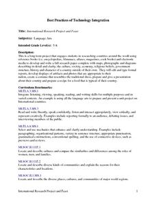
International Research Project and Feast
Students research countries around the world. They develop and write a research paper that includes maps, photographs, and diagrams. They describe the culture, society, economy, religious beliefs, government structure, and history of...
Curated OER
Color Enhanced Maps
Students download or create maps with numerical weather data. They add isolines and color to create regions on their maps. They explore the visual properties of color palettes and create a visualization applying their knowledge.
Curated OER
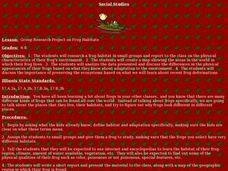
Group Research Project on Frog Habitats
Middle schoolers identify and research a frog habitat in small groups and compile a report to present to the class on the physical characteristics of their frog's environment. Students create a map illustrating areas in the world where...
Curated OER
Canada Data Map
Learners collect data and analyze it. In this algebra lesson, students collect data on the population characteristic in different regions. They use population, culture, settlement and others to help in their criteria.
Curated OER
All About Me-I'm My Own Research Project
Third graders see how to do a research project. They understnad how to categorize information about themselves and relate it to information on sea animals for a future research project. This instructional activity fits in nicely with any...
Curated OER
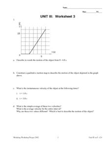
Unit III: 3
In this unit III: 3 worksheet, students describe motion in words and graph drawings. Students calculate the instantaneous velocity and average velocity. Students also graph the displacement of the object in the word problems.
Curated OER
The Economic Differences Between the North and the South Prior to the Civil War
Seventh graders identify and explain the economic differences between the North and the South incorporating photographs and a Venn Diagram to interpret the two sides. They complete a KWL and T-chart to assist them with their task for the...


