Science 4 Inquiry
Edible Plate Tectonics
Many people think they can't observe plate tectonics, but thanks to GPS, we know that Australia moves at a rate of 2.7 inches per year, North America at 1 inches per year, and the Pacific plate at more than 3 inches per year! Scholars...
Curated OER
Lesson Plan on Map Skills for South Asia
Seventh graders observe and discuss an overhead transparency map of South Asia. In small groups, they label a blank map of South Asia, and listen to a lecture on the realm.
California Polytechnic State University
Australian Geography Unit
At the heart of this resource is a beautifully detailed PowerPoint presentation (provided in PDF form) on the overall physical geography of Australia, basic facts about the country, Aboriginal history, and Australia culture and lifestyle.
Australian Government
The Great Artesian Basin
Covering 23% of the continent and holding 64,900 cubic kilometers of water, the Great Artesian Basin is the primary source of water for much of inland Australia. Using detailed student worksheets, experiments, and case studies,...
Cornell University
Too Much of a Good Thing?
Continuing their study of beneficial insects, young entomologists discover where in the world some of these bugs are. By labeling, coloring, and using the scale on a map, pupils explore the territories and arrival of the Asian lady...
Curated OER
Australia
Students identify the climate and type of land that is in Australia. In this Australian climate instructional activity students create a poster that displays the uniqueness of a specific region in Australia.
Curated OER
The Constitution: A New Federation
Students explore political parties by researching world history in class. In this Australian government lesson, students identify the term "federation" and discuss the elements of Australian politics. Students analyze a map of Australia...
PBS
Earthquakes and Volcanoes
Earth's surface constantly changes thanks to a variety of geological forces; in fact, Australia currently moves faster than GPS technology. Scholars connect the idea of continental drift to earthquakes and volcanoes with the help of an...
Curated OER
Land Use in Australian Agriculture
Seventh graders research and map agricultural practices of Australia. They complete a worksheet about their research.
Curated OER
From the Heights to the Depths
Students create a relief map of Asia and Australia. They work in small groups on sections of the map to make one complete map of the continents.
Curated OER
History/Geography
Students review North America, Africa, Europe and Asia. They identify Australia as the smallest continent. They identify Australia as an island continent nicknamed "the land down under." They color a map of Australia.
Curated OER
Australia Cities Map Quiz
In this online interactive geography quiz activity, students respond to 17 identification questions regarding Australian cities. Students have 3 minutes to finish the timed quiz.
Curated OER
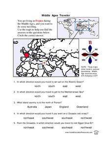
Middle Ages Traveler
In this map worksheet, young scholars are given three maps of France to use to answer multiple choice questions. Students complete an activity from the perspective of a Middle Ages traveler.
Curated OER
Math with Maps and Globes
Students round out their math skills with these ‘round the world' ideas. In this math and geography lesson, students try out time zone sticks, a polar race, and tic-tac-globe to engage them in learning more about globes and the...
Curated OER
World Map and Globe - Lesson 15 Mountains of the World
Learners locate major world mountain ranges. In this geography lesson, students identify major mountain ranges on 6 on of the 7 continents on a large world physical map.
Curated OER
Continents and Oceans
In this geography worksheet, students read a paragraph and learn about the seven continents and five oceans of the world. Students study a map of the world and answer 12 short answer questions. This is an online interactive worksheet.
Curated OER
World Map Labels
In this geography skills worksheet, students identify the countries and bodies of water labelled on the maps of the world, Africa, Asia, Canada, Europe, the Caribbean, the Middle East, North America, Australia, and South America.
Curated OER
Geography Worksheet
In this geography skills worksheet, students respond to 14 short answer questions by using maps and atlases. The maps and atlases are not included.
Curated OER
Australia
First graders are introduced to the country of Australia through books, Internet research, maps and music. They listen to stories, watch videos, decorate cookies and participate in an Australian-themed day of activities.
Curated OER
Coral Reef Geography
In this coral reef geography worksheet, students find locations of reefs on a globe or map. There are 10 instructions to follow. There is no map provided--an atlas, globe or map is needed.
Curated OER
We've got the whole world in our hands
Students explore spatial sense in regards to maps about the globe. In this maps lesson plan, students label oceans, locate the continents and poles, follow directions, and explain the symbols on a map.
Curated OER
Canada Map Quiz
For this online interactive geography quiz worksheet, students respond to 12 multiple choice questions regarding Canadian countries.
Curated OER
A Month of Mapping Literature
Explore the world through literature! With push pins to mark where each story came from, learners examine cultural differences, geographical location, and how those elements affect story content. This lesson could use deeper development,...


