Alberta Learning
Great City-states of the Renaissance
Acting as journalists on a team to determine the most influential city-state of Renaissance Italy, your young historians will research, discuss, and compare the rise of Venice, Florence, and Genoa, and their influence in shaping a...
Curated OER
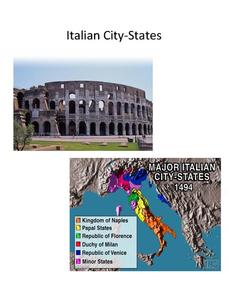
Italian City-States
Check out this packet of worksheets involving mapping activities, vocabulary logging, reading and comprehending informational texts, etc., which focuses on Italian city-states during the fourteenth and fifteenth centuries. There are also...
Curated OER
Across the United States- Home Learning Activity
In this home-school United States map worksheet, students work with a family partner as they study a map of the United States. They talk about the states they have visited, play a game by giving each other clues about states, and write...
Curated OER
United States Map- Map Legend/City Symbols
Students investigate the United States map. In this map skills geography lesson, students explore city symbols on the map legend and identify them. Students use post-it notes to mark various symbols.
Curated OER
Introduction to the United States Map
Students identify a map of the United States. In this United States map instructional activity, students study a map of the United States and find various locations on the map. Students then locate and list the state that touches their...
Curated OER
What Do Maps Show?
This teaching packet is for grades five through eight, and it is organized around geographic themes: location, place, relationships, movement, and regions. There are four full lessons that are complete with posters, weblinks, and...
Curated OER
The Rise of the City States in Greece
Sixth graders examine Ancient Greece and its development of democracy. In this Greek History lesson, 6th graders explore the rise of city-states in Greece and its overall effect on the development of democracy. The class continues with...
Curated OER
Indiana State Map
In this state maps worksheet, students identify the state of Indiana and fill in the state capital, major cities, and other attractions in the state.
Happy Housewife
State Notebooking Pages
When learning about US geography, it can hard to remember facts about 50 different states. Help your young scholars organize all of this information with a collection of easy-to-use note-taking guides.
Curated OER
Montana Map
In this state maps worksheet, students identify the state map of Montana. Students fill in the capital city, the major cities, and other state attractions.
Curated OER
North Carolina Map
In this state maps worksheet, students identify the state map of North Carolina. Students fill in the state capital, the major cities, and other state attractions.
Curated OER
United States Map- State Capitals
Students explore map skills. In this state capital lesson, students view a United States Political Map and identify and use post-it notes to label the state capitals.
Curated OER
Iowa State Map
For this Iowa state map worksheet, students color and label the important cities and physical features. Students also study the background map that shows the location of Iowa in the United States.
Curated OER
Utah Map
In this Utah worksheet, students analyze an outline map of the state of Utah. The capital city is marked. Students add other important cities, bodies of water or other important features. Students color the map.
Curated OER
United States Map- State Capitals
Young scholars explore the state capitals. In this geography lesson, students use a political map to identify the state capitals and place post-it notes on various capitals.
Curated OER
United States Map
In this United States political map worksheet, learners examine national and state boundaries. The map also highlights the location of each of the state capitals and the national capital.
Curated OER
United States Map: Capitals
In this United States outline map worksheet, students make note of the political divisions of 50 states of the nation. This map is labeled with the 50 state capitals.
ProCon
Sanctuary Cities
Should sanctuary cities receive federal funding, or do they defy federal laws? That is precisely the question scholars attempt to answer as they prepare for a class discussion or debate. After reading some brief background information,...
Curated OER
US City Quality of Life Analysis and Comparison
Learners analyze US census data and criteria to compare and measure the quality of life in the country's fifty largest cities. After accessing the 2005 quality of life world report online, students conduct their study to compare three...
Curated OER
West Virginia Map
For this map activities worksheet, students use an outline of the map of West Virginia to add the state capital, major cities, and other state attractions. Students complete 3 activities.
Curated OER
Texas Map
In this Texas activity, students explore the state of Texas. Students look at a blank map of Texas and add the state capital, major cities, and any other major attractions of the state of Texas on the blank map.
Curated OER
The Geography of the United States
Full of bright maps and interesting information, this presentation details U.S. Geography. Slides include basic facts about size, regions, topography, and demographics, as well as fascinating trivia about the United States, including...
Curated OER
United States Map
Students describe cities they are familiar with. In this United States Map instructional activity, students understand how cities are listed on a map. Students become aware of a map legend and the information in it.
Curated OER
Map Memory
Fifth graders, working in a whole class setting, label a United States map with the names of all the states that they know. They transfer the names of the states to an individual map and color it. Next, they receive directions on how to...


